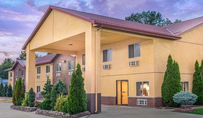
Property Record
425 S West St, Olney, IL 62450

Save to a Folder
{{folder.Name}}
{{folder.ListingIds.length}} Properties
{{folder.ListingIds.length}} Property
Create a New Folder
This Property Is For Sale
Property Detail
425 S West St
11-04-250-084
PLAT/BLOCK/LOT / / PT NE NE NO. 3 UNPLATTED 41
Commercialnec
Richland
C2
Illinois
2025
1.63 AC
2025
Effingham/Central Illinois Area
978000
Other Market Areas
NEARBY LISTINGS FOR SALE OR LEASE
DEMOGRAPHICS near 425 S West St
1 mile
3 mile
5 mile
2025 Total Population
3,771
9,408
10,862
2030 Population
3,745
9,207
10,635
Pop Growth 2025-2030
(0.69%)
(2.14%)
(2.09%)
Average Age
42
42
43
2025 Total Households
1,633
4,000
4,601
HH Growth 2025-2030
(0.55%)
(2.18%)
(2.11%)
Median Household Inc
$57,115
$60,018
$60,604
Avg Household Size
2.20
2.20
2.20
2025 Avg HH Vehicles
2.00
2.00
2.00
Median Home Value
$74,835
$104,574
$119,567
Median Year Built
1959
1967
1969
Nearby Places
Map Layers
Map Styles
 Street
 Aerial
Layers
 Traffic
 Biking
Places
Listings with unknown addresses are not visible on the map
- Restaurants
- Banks
- Shops
- Fitness
- Groceries
Nearby Properties
Address
Land Use
TOTAL SIZE
Lot Size
Zoning
Address
Land Use
TOTAL SIZE
Lot Size
Zoning
0.07 AC
M1
Address
Land Use
TOTAL SIZE
Lot Size
Zoning
52.37 AC
M2
Address
Land Use
TOTAL SIZE
Lot Size
Zoning
53.70 AC
Address
Land Use
TOTAL SIZE
Lot Size
Zoning
3.14 AC
C1
Address
Land Use
TOTAL SIZE
Lot Size
Zoning
3.43 AC
Address
Land Use
TOTAL SIZE
Lot Size
Zoning
7.59 AC
Address
Land Use
TOTAL SIZE
Lot Size
Zoning
8.17 AC
Address
Land Use
TOTAL SIZE
Lot Size
Zoning
2.34 AC
C1
Address
Land Use
TOTAL SIZE
Lot Size
Zoning
0.92 AC
R2
Address
Land Use
TOTAL SIZE
Lot Size
Zoning
Address
Land Use
TOTAL SIZE
Lot Size
Zoning
4.87 AC
M2
Address
Land Use
TOTAL SIZE
Lot Size
Zoning
4.50 AC
Address
Land Use
TOTAL SIZE
Lot Size
Zoning
2.10 AC
C2
Address
Land Use
TOTAL SIZE
Lot Size
Zoning
57.63 AC
A1
Address
Land Use
TOTAL SIZE
Lot Size
Zoning
11.60 AC
Address
Land Use
TOTAL SIZE
Lot Size
Zoning
4.32 AC
R4
Address
Land Use
TOTAL SIZE
Lot Size
Zoning
4.32 AC
Address
Land Use
TOTAL SIZE
Lot Size
Zoning
7.59 AC
M2
Address
Land Use
TOTAL SIZE
Lot Size
Zoning
0.61 AC
C3
Address
Land Use
TOTAL SIZE
Lot Size
Zoning
1.30 AC
Address
Land Use
TOTAL SIZE
Lot Size
Zoning
7.30 AC
M2
Address
Land Use
TOTAL SIZE
Lot Size
Zoning
16.01 AC
M2
Address
Land Use
TOTAL SIZE
Lot Size
Zoning
1.02 AC
C2
Address
Land Use
TOTAL SIZE
Lot Size
Zoning
14.32 AC
Address
Land Use
TOTAL SIZE
Lot Size
Zoning
3.92 AC
Address
Land Use
TOTAL SIZE
Lot Size
Zoning
Address
Land Use
TOTAL SIZE
Lot Size
Zoning
0.81 AC
The World's #1 Commercial Real Estate Marketplace
Connect with us
© 2026 CoStar Group
The information above has been obtained from sources believed reliable. While we do not doubt its accuracy we have not verified it and make no guarantee, warranty or representation about it. It is your responsibility to independently confirm its accuracy and completeness. Any projections, opinions, assumptions, or estimates used are for example only and do not represent the current or future performance of the property. The value of this transaction to you depends on tax and other factors which should be evaluated by your tax, financial, and legal advisors. You and your advisors should conduct a careful, independent investigation of the property to determine to your satisfaction the suitability of the property for your needs.