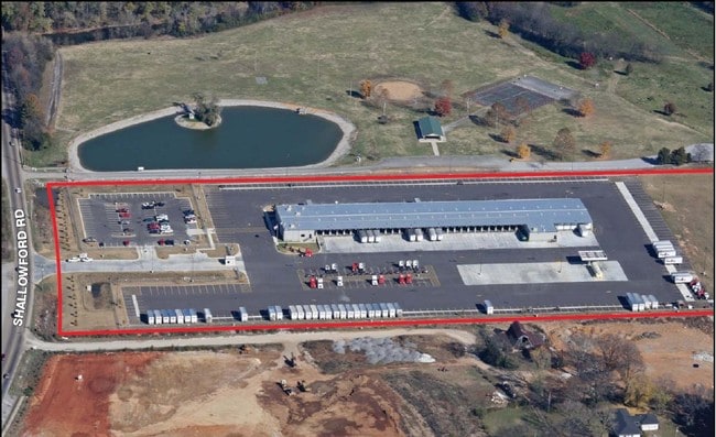
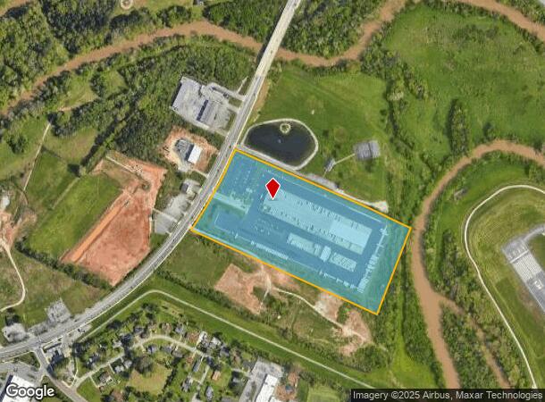
Property Record
4250 Shallowford Rd, Chattanooga, TN 37411
NEARBY LISTINGS FOR SALE OR LEASE
Property Detail
4250 Shallowford Rd
Chattanooga, TN-GA
David H Davis Sub
147D-A-002
LT 1 DAVID H DAVIS SUB PB 85 PG 183
Warehouse
Hamilton
AE
Tennessee
47065C0362G
1
2025
19.22 AC
2025
Outlying Chattanooga
003300
Chattanooga
71,458 SF
DEMOGRAPHICS near 4250 Shallowford Rd
1 Mile
3 Mile
5 Mile
2024 Total Population
2,003
46,270
132,117
2029 Population
2,133
49,424
141,197
Pop Growth 2024-2029
+ 6.49%
+ 6.82%
+ 6.87%
Average Age
43
40
40
2024 Total Households
842
19,869
55,367
HH Growth 2024-2029
+ 6.65%
+ 6.92%
+ 7.03%
Median Household Inc
$42,697
$43,397
$50,999
Avg Household Size
2.30
2.20
2.30
2024 Avg HH Vehicles
2.00
2.00
2.00
Median Home Value
$155,737
$177,325
$195,257
Median Year Built
1966
1965
1971
Nearby Places
Map Layers
Map Styles
 Street
 Aerial
- Restaurants
- Banks
- Shops
- Fitness
- Groceries
PUBLIC TRANSPORTATION
AIRPORT
Lovell Field
DRIVE
WALK
Distance
Lovell Field
13 min
5.6 mi
Freight Ports
Georgia Ports - Savannah
DRIVE
WALK
Distance
Georgia Ports - Savannah
405 min
361.8 mi
Nearby Properties
Address
Land Use
TOTAL SIZE
Lot Size
Zoning
Address
Land Use
TOTAL SIZE
Lot Size
Zoning
831.19 AC
M1
Address
Land Use
TOTAL SIZE
Lot Size
Zoning
292,309 SF
45.28 AC
M1
Address
Land Use
TOTAL SIZE
Lot Size
Zoning
20,964 SF
17.72 AC
R1
Address
Land Use
TOTAL SIZE
Lot Size
Zoning
99,202 SF
17.32 AC
Address
Land Use
TOTAL SIZE
Lot Size
Zoning
291,314 SF
29.69 AC
M1
Address
Land Use
TOTAL SIZE
Lot Size
Zoning
6,912 SF
19.97 AC
Address
Land Use
TOTAL SIZE
Lot Size
Zoning
118,644 SF
10.20 AC
R3
Address
Land Use
TOTAL SIZE
Lot Size
Zoning
8,032 SF
19.80 AC
Address
Land Use
TOTAL SIZE
Lot Size
Zoning
94,369 SF
26.27 AC
R2
Address
Land Use
TOTAL SIZE
Lot Size
Zoning
181,612 SF
14.10 AC
Address
Land Use
TOTAL SIZE
Lot Size
Zoning
790,207 SF
53.84 AC
C2
Address
Land Use
TOTAL SIZE
Lot Size
Zoning
63,716 SF
3.55 AC
Address
Land Use
TOTAL SIZE
Lot Size
Zoning
32,261 SF
6.43 AC
R1
Address
Land Use
TOTAL SIZE
Lot Size
Zoning
54,534 SF
4.51 AC
R3
Address
Land Use
TOTAL SIZE
Lot Size
Zoning
74,798 SF
R1
Address
Land Use
TOTAL SIZE
Lot Size
Zoning
18,360 SF
9.60 AC
R3
Address
Land Use
TOTAL SIZE
Lot Size
Zoning
67,735 SF
17.32 AC
M1
Address
Land Use
TOTAL SIZE
Lot Size
Zoning
209,168 SF
23.28 AC
C2
Address
Land Use
TOTAL SIZE
Lot Size
Zoning
72,906 SF
11.46 AC
M2
Address
Land Use
TOTAL SIZE
Lot Size
Zoning
306,298 SF
33.40 AC
M1
Address
Land Use
TOTAL SIZE
Lot Size
Zoning
121,276 SF
10.50 AC
R3
Address
Land Use
TOTAL SIZE
Lot Size
Zoning
240,000 SF
16.91 AC
IN
Address
Land Use
TOTAL SIZE
Lot Size
Zoning
925 SF
10.05 AC
R1
Address
Land Use
TOTAL SIZE
Lot Size
Zoning
274,060 SF
20.11 AC
M1
Address
Land Use
TOTAL SIZE
Lot Size
Zoning
77,975 SF
11.93 AC
C2
Address
Land Use
TOTAL SIZE
Lot Size
Zoning
35,740 SF
5.20 AC
R2
Address
Land Use
TOTAL SIZE
Lot Size
Zoning
7,680 SF
11.06 AC
Address
Land Use
TOTAL SIZE
Lot Size
Zoning
7,352 SF
7.40 AC
R3
Address
Land Use
TOTAL SIZE
Lot Size
Zoning
68,060 SF
6.17 AC
R2
Address
Land Use
TOTAL SIZE
Lot Size
Zoning
81,827 SF
8.84 AC
The World's #1 Commercial Real Estate Marketplace
Connect with us
© 2026 CoStar Group
The information above has been obtained from sources believed reliable. While we do not doubt its accuracy we have not verified it and make no guarantee, warranty or representation about it. It is your responsibility to independently confirm its accuracy and completeness. Any projections, opinions, assumptions, or estimates used are for example only and do not represent the current or future performance of the property. The value of this transaction to you depends on tax and other factors which should be evaluated by your tax, financial, and legal advisors. You and your advisors should conduct a careful, independent investigation of the property to determine to your satisfaction the suitability of the property for your needs.