Property Record
4251 Old Route 22, Brewster, NY 10509
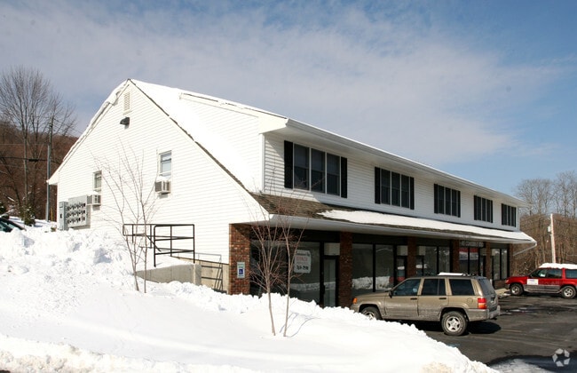


This Property Is For Sale
Current Lease Availabilities
NEARBY LISTINGS FOR SALE OR LEASE
Property Detail
4251 Old Route 22
372400-024-000-0001-075-000-0000
Final Subdivision Plat Allen Schoen
Officebuilding
Putnam
X
New York
36079C0152E
75.00
2024
1.74 AC
2024
Brewster
010201
Westchester/So Connecticut
7,400 SF
New York-Jersey City-White Plains, NY-NJ
DEMOGRAPHICS near 4251 Old Route 22
1 Mile
3 Mile
5 Mile
2024 Total Population
537
12,454
39,127
2029 Population
534
12,501
39,206
Pop Growth 2024-2029
(0.56%)
+ 0.38%
+ 0.20%
Average Age
42
43
43
2024 Total Households
173
4,234
13,905
HH Growth 2024-2029
(0.58%)
+ 0.35%
+ 0.18%
Median Household Inc
$153,846
$108,199
$109,318
Avg Household Size
3.00
2.70
2.70
2024 Avg HH Vehicles
3.00
2.00
2.00
Median Home Value
$493,420
$364,236
$372,380
Median Year Built
1982
1969
1971
Nearby Places
Map Layers
Map Styles
 Street
 Aerial
- Restaurants
- Banks
- Shops
- Fitness
- Groceries
PUBLIC TRANSPORTATION
COMMUTER RAIL
Patterson Station (Harlem Line - Metro-North Commuter Railroad Company (Metro-North))
DRIVE
WALK
Distance
Patterson Station (Harlem Line - Metro-North Commuter Railroad Company (Metro-North))
7 min
4.1 mi
Brewster Station (Harlem Line - Metro-North Commuter Railroad Company (Metro-North))
DRIVE
WALK
Distance
Brewster Station (Harlem Line - Metro-North Commuter Railroad Company (Metro-North))
14 min
7.6 mi
AIRPORT
Westchester County
DRIVE
WALK
Distance
Westchester County
42 min
31.7 mi
New York Stewart International
DRIVE
WALK
Distance
New York Stewart International
49 min
34.4 mi
Nearby Properties
Address
Land Use
TOTAL SIZE
Lot Size
Zoning
Address
Land Use
TOTAL SIZE
Lot Size
Zoning
1,498,293 SF
361.91 AC
R4
Address
Land Use
TOTAL SIZE
Lot Size
Zoning
282,770 SF
50.83 AC
R160
Address
Land Use
TOTAL SIZE
Lot Size
Zoning
170,015 SF
70.32 AC
R160
Address
Land Use
TOTAL SIZE
Lot Size
Zoning
116,000 SF
13.29 AC
SP Z
Address
Land Use
TOTAL SIZE
Lot Size
Zoning
12,064 SF
12.10 AC
C1
Address
Land Use
TOTAL SIZE
Lot Size
Zoning
109,593 SF
16.65 AC
C1
Address
Land Use
TOTAL SIZE
Lot Size
Zoning
97,708 SF
11.42 AC
OP2
Address
Land Use
TOTAL SIZE
Lot Size
Zoning
48,811 SF
11.66 AC
OP2
Address
Land Use
TOTAL SIZE
Lot Size
Zoning
150,000 SF
10.40 AC
OP2
Address
Land Use
TOTAL SIZE
Lot Size
Zoning
118,990 SF
29.02 AC
MWFH
Address
Land Use
TOTAL SIZE
Lot Size
Zoning
131,719 SF
19.05 AC
OP2
Address
Land Use
TOTAL SIZE
Lot Size
Zoning
178,472 SF
2.74 AC
R4
Address
Land Use
TOTAL SIZE
Lot Size
Zoning
131,700 SF
7.82 AC
OP2
Address
Land Use
TOTAL SIZE
Lot Size
Zoning
29,369 SF
19.29 AC
SP Z
Address
Land Use
TOTAL SIZE
Lot Size
Zoning
129,961 SF
31.51 AC
C1
Address
Land Use
TOTAL SIZE
Lot Size
Zoning
61,114 SF
6.06 AC
OP2
Address
Land Use
TOTAL SIZE
Lot Size
Zoning
40,613 SF
49.91 AC
I
Address
Land Use
TOTAL SIZE
Lot Size
Zoning
77,537 SF
19.41 AC
R1
Address
Land Use
TOTAL SIZE
Lot Size
Zoning
72,560 SF
11.25 AC
OP2
Address
Land Use
TOTAL SIZE
Lot Size
Zoning
41,082 SF
21 AC
R4
Address
Land Use
TOTAL SIZE
Lot Size
Zoning
101,890 SF
6.02 AC
OP1
Address
Land Use
TOTAL SIZE
Lot Size
Zoning
Address
Land Use
TOTAL SIZE
Lot Size
Zoning
12,871 SF
277.38 AC
R4
Address
Land Use
TOTAL SIZE
Lot Size
Zoning
46.30 AC
SP Z
Address
Land Use
TOTAL SIZE
Lot Size
Zoning
Address
Land Use
TOTAL SIZE
Lot Size
Zoning
55,331 SF
95.63 AC
R4
Address
Land Use
TOTAL SIZE
Lot Size
Zoning
Address
Land Use
TOTAL SIZE
Lot Size
Zoning
4,000 SF
43.18 AC
RMF
Address
Land Use
TOTAL SIZE
Lot Size
Zoning
Address
Land Use
TOTAL SIZE
Lot Size
Zoning
25,278 SF
7.28 AC
OP2
The World's #1 Commercial Real Estate Marketplace
Connect with us
© 2026 CoStar Group
The information above has been obtained from sources believed reliable. While we do not doubt its accuracy we have not verified it and make no guarantee, warranty or representation about it. It is your responsibility to independently confirm its accuracy and completeness. Any projections, opinions, assumptions, or estimates used are for example only and do not represent the current or future performance of the property. The value of this transaction to you depends on tax and other factors which should be evaluated by your tax, financial, and legal advisors. You and your advisors should conduct a careful, independent investigation of the property to determine to your satisfaction the suitability of the property for your needs.