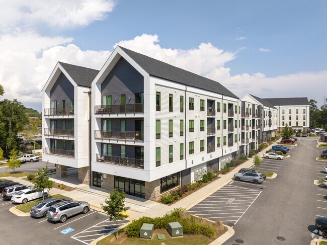
Property Record
4255 Suwanee Dam Rd, Suwanee, GA 30024


Current Lease Availabilities
Property Detail
4255 Suwanee Dam Rd
7-252-888
TRACT 2 STONECYPHER RD
Apartment
Gwinnett
PMUD
Georgia
B and X Area of moderate flood hazard, usually the area between the limits of the 100-year and 500-year floods.
14.34 AC
2024
Duluth
2025
Atlanta
050223
Atlanta-Sandy Springs-Roswell, GA
370,414 SF
NEARBY LISTINGS FOR SALE OR LEASE
DEMOGRAPHICS near 4255 Suwanee Dam Rd
1 mile
3 mile
5 mile
2025 Total Population
8,661
60,771
172,107
2030 Population
9,199
63,962
181,117
Pop Growth 2025-2030
+ 6.21%
+ 5.25%
+ 5.24%
Average Age
40
39
39
2025 Total Households
2,973
19,978
57,126
HH Growth 2025-2030
+ 6.56%
+ 5.47%
+ 5.37%
Median Household Inc
$113,714
$124,203
$114,618
Avg Household Size
2.90
3.00
3.00
2025 Avg HH Vehicles
3.00
2.00
2.00
Median Home Value
$483,176
$506,725
$483,709
Median Year Built
2002
2000
1999
Nearby Places
Map Layers
Map Styles
 Street
 Aerial
Layers
 Traffic
 Biking
Places
Listings with unknown addresses are not visible on the map
- Restaurants
- Banks
- Shops
- Fitness
- Groceries
Nearby Properties
Address
Land Use
TOTAL SIZE
Lot Size
Zoning
Address
Land Use
TOTAL SIZE
Lot Size
Zoning
509,302 SF
55.13 AC
RM8
Address
Land Use
TOTAL SIZE
Lot Size
Zoning
534,578 SF
44.21 AC
RM8
Address
Land Use
TOTAL SIZE
Lot Size
Zoning
393,939 SF
42.21 AC
RM8
Address
Land Use
TOTAL SIZE
Lot Size
Zoning
379,183 SF
6.09 AC
PMUD
Address
Land Use
TOTAL SIZE
Lot Size
Zoning
151,663 SF
42.77 AC
BG
Address
Land Use
TOTAL SIZE
Lot Size
Zoning
234,420 SF
10.35 AC
PMUD
Address
Land Use
TOTAL SIZE
Lot Size
Zoning
447,399 SF
25.71 AC
GCA
Address
Land Use
TOTAL SIZE
Lot Size
Zoning
240,556 SF
49.13 AC
HM1
Address
Land Use
TOTAL SIZE
Lot Size
Zoning
332,011 SF
8.84 AC
PMUD
Address
Land Use
TOTAL SIZE
Lot Size
Zoning
99,600 SF
91.27 AC
CR1
Address
Land Use
TOTAL SIZE
Lot Size
Zoning
379,621 SF
71.66 AC
RES3
Address
Land Use
TOTAL SIZE
Lot Size
Zoning
184,890 SF
3 AC
PMUD
Address
Land Use
TOTAL SIZE
Lot Size
Zoning
408 SF
217.12 AC
R100
Address
Land Use
TOTAL SIZE
Lot Size
Zoning
185,524 SF
12.61 AC
M1
Address
Land Use
TOTAL SIZE
Lot Size
Zoning
1,682 SF
303.40 AC
A1
Address
Land Use
TOTAL SIZE
Lot Size
Zoning
115,555 SF
34.65 AC
R100MOD
Address
Land Use
TOTAL SIZE
Lot Size
Zoning
127,635 SF
19.57 AC
C2
Address
Land Use
TOTAL SIZE
Lot Size
Zoning
1,316 SF
62.15 AC
R140
Address
Land Use
TOTAL SIZE
Lot Size
Zoning
95,476 SF
10.80 AC
HM1
Address
Land Use
TOTAL SIZE
Lot Size
Zoning
106,273 SF
5.16 AC
OI
Address
Land Use
TOTAL SIZE
Lot Size
Zoning
67,006 SF
11.59 AC
CBD
Address
Land Use
TOTAL SIZE
Lot Size
Zoning
100 SF
121.48 AC
A1
Address
Land Use
TOTAL SIZE
Lot Size
Zoning
203,281 SF
16.22 AC
M1
Address
Land Use
TOTAL SIZE
Lot Size
Zoning
98,575 SF
12.37 AC
M1
Address
Land Use
TOTAL SIZE
Lot Size
Zoning
93,600 SF
1.79 AC
BG
Address
Land Use
TOTAL SIZE
Lot Size
Zoning
152,602 SF
27.83 AC
A1
Address
Land Use
TOTAL SIZE
Lot Size
Zoning
164,478 SF
34.80 AC
A1
Address
Land Use
TOTAL SIZE
Lot Size
Zoning
36,841 SF
5.30 AC
C3
Address
Land Use
TOTAL SIZE
Lot Size
Zoning
104,966 SF
3.91 AC
PMUD
The World's #1 Commercial Real Estate Marketplace
Connect with us
© 2026 CoStar Group
The information above has been obtained from sources believed reliable. While we do not doubt its accuracy we have not verified it and make no guarantee, warranty or representation about it. It is your responsibility to independently confirm its accuracy and completeness. Any projections, opinions, assumptions, or estimates used are for example only and do not represent the current or future performance of the property. The value of this transaction to you depends on tax and other factors which should be evaluated by your tax, financial, and legal advisors. You and your advisors should conduct a careful, independent investigation of the property to determine to your satisfaction the suitability of the property for your needs.