Property Record
4257 34Th St, Lubbock, TX 79410


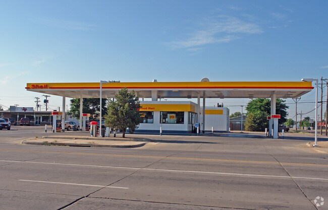
Property Detail
4257 34Th St
Lubbock, TX
PAYNE L 1A
R101701
LUBBOCK
Restaurantbuilding
Texas
B and X Area of moderate flood hazard, usually the area between the limits of the 100-year and 500-year floods.
10
2024
0.79 AC
2025
Southwest Inner Loop
001905
Lubbock
3,956 SF
NEARBY LISTINGS FOR SALE OR LEASE
DEMOGRAPHICS near 4257 34Th St
1 mile
3 mile
5 mile
2024 Total Population
12,978
114,506
232,972
2029 Population
13,490
118,348
242,349
Pop Growth 2024-2029
+ 3.95%
+ 3.36%
+ 4.02%
Average Age
36
35
36
2024 Total Households
4,994
46,053
92,827
HH Growth 2024-2029
+ 4.27%
+ 3.98%
+ 4.47%
Median Household Inc
$56,484
$50,058
$55,020
Avg Household Size
2.50
2.30
2.40
2024 Avg HH Vehicles
2.00
2.00
2.00
Median Home Value
$160,747
$189,243
$206,654
Median Year Built
1962
1973
1983
Nearby Places
Map Layers
Map Styles
 Street
 Aerial
Transit
 Traffic
 Biking
Places
Listings with unknown addresses are not visible on the map
- Restaurants
- Banks
- Shops
- Fitness
- Groceries
PUBLIC TRANSPORTATION
AIRPORT
Lubbock Preston Smith International
Drive
Walk
Distance
Lubbock Preston Smith International
28 min
14.7 mi
Nearby Properties
Address
Land Use
TOTAL SIZE
Lot Size
Zoning
Address
Land Use
TOTAL SIZE
Lot Size
Zoning
791,096 SF
63.76 AC
Address
Land Use
TOTAL SIZE
Lot Size
Zoning
380,785 SF
36.72 AC
Address
Land Use
TOTAL SIZE
Lot Size
Zoning
351,150 SF
3.65 AC
Address
Land Use
TOTAL SIZE
Lot Size
Zoning
21,110 SF
13.02 AC
Address
Land Use
TOTAL SIZE
Lot Size
Zoning
321,540 SF
10.87 AC
Address
Land Use
TOTAL SIZE
Lot Size
Zoning
286,541 SF
4.25 AC
Address
Land Use
TOTAL SIZE
Lot Size
Zoning
360,108 SF
18.63 AC
Address
Land Use
TOTAL SIZE
Lot Size
Zoning
304,276 SF
22.69 AC
Address
Land Use
TOTAL SIZE
Lot Size
Zoning
179,627 SF
2.66 AC
Address
Land Use
TOTAL SIZE
Lot Size
Zoning
274,547 SF
18.92 AC
Address
Land Use
TOTAL SIZE
Lot Size
Zoning
473,857 SF
17.64 AC
Address
Land Use
TOTAL SIZE
Lot Size
Zoning
244,834 SF
14.54 AC
Address
Land Use
TOTAL SIZE
Lot Size
Zoning
230,286 SF
8.01 AC
Address
Land Use
TOTAL SIZE
Lot Size
Zoning
122,976 SF
14.50 AC
Address
Land Use
TOTAL SIZE
Lot Size
Zoning
396,570 SF
2.56 AC
Address
Land Use
TOTAL SIZE
Lot Size
Zoning
106,894 SF
5.83 AC
Address
Land Use
TOTAL SIZE
Lot Size
Zoning
400,401 SF
2.76 AC
Address
Land Use
TOTAL SIZE
Lot Size
Zoning
102,209 SF
14 AC
Address
Land Use
TOTAL SIZE
Lot Size
Zoning
176,165 SF
36.61 AC
Address
Land Use
TOTAL SIZE
Lot Size
Zoning
64,800 SF
0.94 AC
Address
Land Use
TOTAL SIZE
Lot Size
Zoning
153,416 SF
3.14 AC
Address
Land Use
TOTAL SIZE
Lot Size
Zoning
247,870 SF
11.48 AC
Address
Land Use
TOTAL SIZE
Lot Size
Zoning
152,857 SF
7.87 AC
Address
Land Use
TOTAL SIZE
Lot Size
Zoning
219,352 SF
21.90 AC
Address
Land Use
TOTAL SIZE
Lot Size
Zoning
143,905 SF
0.28 AC
Address
Land Use
TOTAL SIZE
Lot Size
Zoning
231,940 SF
7.67 AC
Address
Land Use
TOTAL SIZE
Lot Size
Zoning
177,643 SF
10.13 AC
Address
Land Use
TOTAL SIZE
Lot Size
Zoning
156,495 SF
15.85 AC
Address
Land Use
TOTAL SIZE
Lot Size
Zoning
138,202 SF
11.33 AC
Address
Land Use
TOTAL SIZE
Lot Size
Zoning
24,540 SF
8.06 AC
The World's #1 Commercial Real Estate Marketplace
Connect with us
© 2026 CoStar Group
The information above has been obtained from sources believed reliable. While we do not doubt its accuracy we have not verified it and make no guarantee, warranty or representation about it. It is your responsibility to independently confirm its accuracy and completeness. Any projections, opinions, assumptions, or estimates used are for example only and do not represent the current or future performance of the property. The value of this transaction to you depends on tax and other factors which should be evaluated by your tax, financial, and legal advisors. You and your advisors should conduct a careful, independent investigation of the property to determine to your satisfaction the suitability of the property for your needs.