No Photo
Property Record
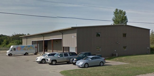
42589 W Red Arrow Hwy, Paw Paw, MI 49079
NEARBY LISTINGS FOR SALE OR LEASE
-
-
View all Paw Paw listings for sale on LoopNet.com
Property Detail
42589 W Red Arrow Hwy
80-14-017-011-02
226-A1 17-3-14 887-647 1276-95 1685-308 1691-682 *** COM AT S 1/4 POST OF SEC, TH N 0 DEG 13' 22"W ALG N&S 1/4 L 2632.26' TO
Distributionwarehouseregional
Van Buren
X
Michigan
26159C0330C
13.76 AC
2024
Van Buren County
2025
West Michigan
011801
Kalamazoo-Portage, MI
77,140 SF
DEMOGRAPHICS near 42589 W Red Arrow Hwy
1 Mile
3 Mile
5 Mile
2024 Total Population
222
2,613
10,416
2029 Population
222
2,618
10,320
Pop Growth 2024-2029
0.00%
+ 0.19%
(0.92%)
Average Age
47
45
42
2024 Total Households
92
1,065
4,217
HH Growth 2024-2029
(1.09%)
(0.09%)
(1.26%)
Median Household Inc
$68,437
$72,938
$62,696
Avg Household Size
2.40
2.40
2.40
2024 Avg HH Vehicles
2.00
2.00
2.00
Median Home Value
$299,999
$218,862
$174,763
Median Year Built
1974
1975
1972
Nearby Places
- Restaurants
- Banks
- Shops
- Fitness
- Groceries
PUBLIC TRANSPORTATION
AIRPORT
Kalamazoo/Battle Creek International
DRIVE
WALK
Distance
Kalamazoo/Battle Creek International
32 min
24.0 mi
Freight Ports
Port Milwaukee
DRIVE
WALK
Distance
Port Milwaukee
247 min
209.1 mi
Nearby Properties
Address
Land Use
TOTAL SIZE
Lot Size
Zoning
Address
Land Use
TOTAL SIZE
Lot Size
Zoning
391,023 SF
19.86 AC
HCI
Address
Land Use
TOTAL SIZE
Lot Size
Zoning
115,552 SF
35.06 AC
HCI
Address
Land Use
TOTAL SIZE
Lot Size
Zoning
176,100 SF
15.46 AC
HCI
Address
Land Use
TOTAL SIZE
Lot Size
Zoning
233,484 SF
31.21 AC
HCI
Address
Land Use
TOTAL SIZE
Lot Size
Zoning
11.48 AC
MULTI
Address
Land Use
TOTAL SIZE
Lot Size
Zoning
5,160 SF
302 AC
MULTI
Address
Land Use
TOTAL SIZE
Lot Size
Zoning
448 SF
19.86 AC
MULTI
Address
Land Use
TOTAL SIZE
Lot Size
Zoning
64,584 SF
DEFAULT
Address
Land Use
TOTAL SIZE
Lot Size
Zoning
4,092 SF
222 AC
MULTI
Address
Land Use
TOTAL SIZE
Lot Size
Zoning
2,332 SF
171.06 AC
AGR
Address
Land Use
TOTAL SIZE
Lot Size
Zoning
2,526 SF
81.19 AC
AGR
Address
Land Use
TOTAL SIZE
Lot Size
Zoning
17,134 SF
3.38 AC
HCI
Address
Land Use
TOTAL SIZE
Lot Size
Zoning
41,535 SF
6.35 AC
GC
Address
Land Use
TOTAL SIZE
Lot Size
Zoning
6,690 SF
10.24 AC
AGR
Address
Land Use
TOTAL SIZE
Lot Size
Zoning
54,446 SF
15.28 AC
VE
Address
Land Use
TOTAL SIZE
Lot Size
Zoning
2,500 SF
17.15 AC
HCI
Address
Land Use
TOTAL SIZE
Lot Size
Zoning
4,404 SF
2.50 AC
HSC
Address
Land Use
TOTAL SIZE
Lot Size
Zoning
103.50 AC
MULTI
Address
Land Use
TOTAL SIZE
Lot Size
Zoning
13,144 SF
7.49 AC
MULTI
Address
Land Use
TOTAL SIZE
Lot Size
Zoning
1,920 SF
139.94 AC
AGR
Address
Land Use
TOTAL SIZE
Lot Size
Zoning
34,288 SF
3.85 AC
VE
Address
Land Use
TOTAL SIZE
Lot Size
Zoning
22,500 SF
7.72 AC
GC
Address
Land Use
TOTAL SIZE
Lot Size
Zoning
2,268 SF
124.62 AC
MULTI
Address
Land Use
TOTAL SIZE
Lot Size
Zoning
32.53 AC
HCI
Address
Land Use
TOTAL SIZE
Lot Size
Zoning
155.61 AC
AGR
Address
Land Use
TOTAL SIZE
Lot Size
Zoning
13,200 SF
DEFAULT
Address
Land Use
TOTAL SIZE
Lot Size
Zoning
28,300 SF
3.89 AC
GC
Address
Land Use
TOTAL SIZE
Lot Size
Zoning
2,505 SF
80.01 AC
AGR
Address
Land Use
TOTAL SIZE
Lot Size
Zoning
2 AC
WFR
The World's #1 Commercial Real Estate Marketplace
Connect with us
© 2025 CoStar Group
The information above has been obtained from sources believed reliable. While we do not doubt its accuracy we have not verified it and make no guarantee, warranty or representation about it. It is your responsibility to independently confirm its accuracy and completeness. Any projections, opinions, assumptions, or estimates used are for example only and do not represent the current or future performance of the property. The value of this transaction to you depends on tax and other factors which should be evaluated by your tax, financial, and legal advisors. You and your advisors should conduct a careful, independent investigation of the property to determine to your satisfaction the suitability of the property for your needs.