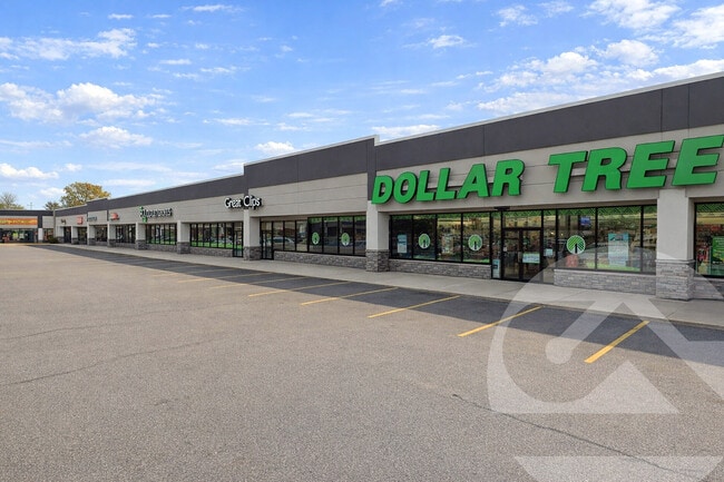
Property Record
426 E Edgewood Blvd, Lansing, MI 48911

Current Lease Availabilities
General Retail LEASE
$16.00 SF/YR
49,265 SF
Property Detail
426 E Edgewood Blvd
01-05-09-403-082
LOT 29 KAHRES FARM NO 2, EXCEPT COM AT SE COR OF LOT 29 TH S62?01'58 W ALONG THE S LINE OF LOT 29 160 FT TO THE POB TH S
Communitycenter
INGHAM
G-2 WHO
Michigan
B and X Area of moderate flood hazard, usually the area between the limits of the 100-year and 500-year floods.
29,160
2024
10.94 AC
2025
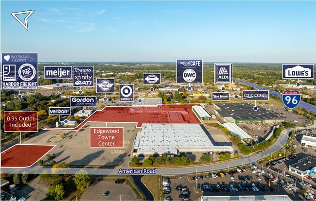
Southern Lansing
005201
West Michigan
88,453 SF
Lansing-East Lansing, MI
NEARBY LISTINGS FOR SALE OR LEASE
-
-
-
-
-
438-462 E Edgewood Blvd & SEC American Rd & E Edgewood Blvd
Lansing, MI 48911
$16.00 SF/YR
49,265 SF
Retail
-
-
-
View all Lansing listings for lease on LoopNet.com
DEMOGRAPHICS near 426 E Edgewood Blvd
1 mile
3 mile
5 mile
2025 Total Population
8,519
62,532
112,185
2030 Population
8,639
63,113
113,712
Pop Growth 2025-2030
+ 1.41%
+ 0.93%
+ 1.36%
Average Age
38
38
38
2025 Total Households
3,788
26,637
47,239
HH Growth 2025-2030
+ 1.27%
+ 1.02%
+ 1.39%
Median Household Inc
$51,960
$60,768
$59,596
Avg Household Size
2.20
2.30
2.20
2025 Avg HH Vehicles
1.00
2.00
2.00
Median Home Value
$149,366
$159,097
$157,185
Median Year Built
1974
1973
1968
Nearby Places
Map Layers
Map Styles
 Street
 Aerial
Layers
 Traffic
 Biking
Places
Listings with unknown addresses are not visible on the map
- Restaurants
- Banks
- Shops
- Fitness
- Groceries
PUBLIC TRANSPORTATION
COMMUTER RAIL
East Lansing Amtrak Station (Blue Water - Amtrak)
Drive
Walk
Distance
East Lansing Amtrak Station (Blue Water - Amtrak)
12 min
7.5 mi
AIRPORT
Capital Region International
Drive
Walk
Distance
Capital Region International
19 min
9.6 mi
Freight Ports
Port of Toledo
Drive
Walk
Distance
Port of Toledo
144 min
121.6 mi
Nearby Properties
Address
Land Use
TOTAL SIZE
Lot Size
Zoning
Address
Land Use
TOTAL SIZE
Lot Size
Zoning
49,336 SF
9.60 AC
F COMM
Address
Land Use
TOTAL SIZE
Lot Size
Zoning
21,447 SF
56.20 AC
RM
Address
Land Use
TOTAL SIZE
Lot Size
Zoning
3,246 SF
13.54 AC
DM-1 RE
Address
Land Use
TOTAL SIZE
Lot Size
Zoning
178,096 SF
22.80 AC
IP
Address
Land Use
TOTAL SIZE
Lot Size
Zoning
2,920 SF
36.77 AC
CUP
Address
Land Use
TOTAL SIZE
Lot Size
Zoning
410 AC
Address
Land Use
TOTAL SIZE
Lot Size
Zoning
8,857 SF
21.22 AC
A RESID
Address
Land Use
TOTAL SIZE
Lot Size
Zoning
31,215 SF
19.19 AC
CUP
Address
Land Use
TOTAL SIZE
Lot Size
Zoning
7,868 SF
12.03 AC
RM
Address
Land Use
TOTAL SIZE
Lot Size
Zoning
8,341 SF
27.70 AC
RM
Address
Land Use
TOTAL SIZE
Lot Size
Zoning
23,940 SF
13.44 AC
CUP
Address
Land Use
TOTAL SIZE
Lot Size
Zoning
17,920 SF
208 AC
Address
Land Use
TOTAL SIZE
Lot Size
Zoning
351 SF
20.90 AC
Address
Land Use
TOTAL SIZE
Lot Size
Zoning
1,642 SF
288 AC
DM-1 RE
Address
Land Use
TOTAL SIZE
Lot Size
Zoning
10,112 SF
12.57 AC
RM-1
Address
Land Use
TOTAL SIZE
Lot Size
Zoning
47,352 SF
2.41 AC
TC
Address
Land Use
TOTAL SIZE
Lot Size
Zoning
14,981 SF
12.66 AC
R-1E
Address
Land Use
TOTAL SIZE
Lot Size
Zoning
75,476 SF
17.70 AC
Address
Land Use
TOTAL SIZE
Lot Size
Zoning
168,480 SF
15.30 AC
G-2 WHO
Address
Land Use
TOTAL SIZE
Lot Size
Zoning
3,528 SF
230 AC
Address
Land Use
TOTAL SIZE
Lot Size
Zoning
80,080 SF
7.91 AC
D-1 PRO
Address
Land Use
TOTAL SIZE
Lot Size
Zoning
161,686 SF
220 AC
D-1 PRO
Address
Land Use
TOTAL SIZE
Lot Size
Zoning
Address
Land Use
TOTAL SIZE
Lot Size
Zoning
8,469 SF
160 AC
Address
Land Use
TOTAL SIZE
Lot Size
Zoning
29,808 SF
9.66 AC
CUP
Address
Land Use
TOTAL SIZE
Lot Size
Zoning
72,722 SF
3.99 AC
A-1 RES
Address
Land Use
TOTAL SIZE
Lot Size
Zoning
16,913 SF
11.25 AC
R-1E
Address
Land Use
TOTAL SIZE
Lot Size
Zoning
15,439 SF
13.13 AC
R-1E
Address
Land Use
TOTAL SIZE
Lot Size
Zoning
26,042 SF
3.58 AC
C-2
Address
Land Use
TOTAL SIZE
Lot Size
Zoning
164 AC
The World's #1 Commercial Real Estate Marketplace
Connect with us
© 2026 CoStar Group
The information above has been obtained from sources believed reliable. While we do not doubt its accuracy we have not verified it and make no guarantee, warranty or representation about it. It is your responsibility to independently confirm its accuracy and completeness. Any projections, opinions, assumptions, or estimates used are for example only and do not represent the current or future performance of the property. The value of this transaction to you depends on tax and other factors which should be evaluated by your tax, financial, and legal advisors. You and your advisors should conduct a careful, independent investigation of the property to determine to your satisfaction the suitability of the property for your needs.