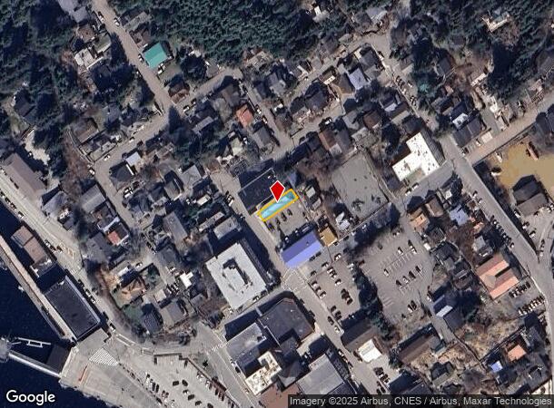
Property Record
426 Main St, Ketchikan, AK 99901
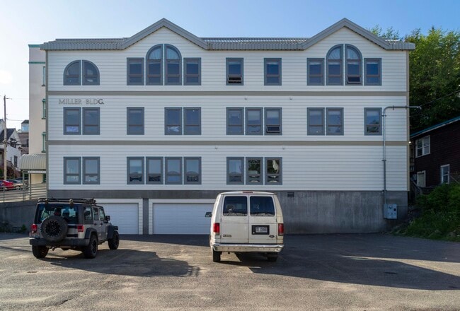

This Property Is For Sale
NEARBY LISTINGS FOR SALE OR LEASE
-
-
View all Ketchikan listings for sale on LoopNet.com
Property Detail
426 Main St
Ketchikan, AK
City
01-1431-010100
THE SOUTHEASTERLY 24.00 FEET OF LOT 5, BLOCK 13 (ALSO KNOWN AS LOT 5-B, BLOCK 13) UNITED STATES SURVEY 437, KETCHIKAN RECORDING DISTRICT, FIRST JUDICIAL DISTRICT, STATE OF ALASKA.
Commercialnec
Ketchikan Gateway
X
Alaska
02130C0226C
5
2025
0.06 AC
2025
Alaska Regional
000300
Other Market Areas
7,183 SF
DEMOGRAPHICS near 426 Main St
1 Mile
3 Mile
5 Mile
2024 Total Population
3,520
9,327
10,242
2029 Population
3,493
9,244
10,135
Pop Growth 2024-2029
(0.77%)
(0.89%)
(1.04%)
Average Age
39
40
40
2024 Total Households
1,463
3,646
4,013
HH Growth 2024-2029
(0.82%)
(0.91%)
(1.07%)
Median Household Inc
$54,814
$66,966
$70,695
Avg Household Size
2.30
2.40
2.40
2024 Avg HH Vehicles
1.00
2.00
2.00
Median Home Value
$285,245
$312,443
$325,452
Median Year Built
1958
1972
1973
Nearby Places
Map Layers
Map Styles
 Street
 Aerial
- Restaurants
- Banks
- Shops
- Fitness
- Groceries
PUBLIC TRANSPORTATION
AIRPORT
Ketchikan International
DRIVE
WALK
Distance
Ketchikan International
14 min
3.3 mi
Freight Ports
Vancouver
DRIVE
WALK
Distance
Vancouver
1,577 min
1,060.2 mi
Nearby Properties
Address
Land Use
TOTAL SIZE
Lot Size
Zoning
Address
Land Use
TOTAL SIZE
Lot Size
Zoning
75,380 SF
17.19 AC
Address
Land Use
TOTAL SIZE
Lot Size
Zoning
211,553 SF
5.13 AC
PLI
Address
Land Use
TOTAL SIZE
Lot Size
Zoning
180,634 SF
11.96 AC
PLI
Address
Land Use
TOTAL SIZE
Lot Size
Zoning
71,424 SF
11.16 AC
PLI
Address
Land Use
TOTAL SIZE
Lot Size
Zoning
31,693 SF
997 AC
FD
Address
Land Use
TOTAL SIZE
Lot Size
Zoning
85,752 SF
42.79 AC
PLI
Address
Land Use
TOTAL SIZE
Lot Size
Zoning
4,016 SF
37.02 AC
Address
Land Use
TOTAL SIZE
Lot Size
Zoning
163.44 AC
CG
Address
Land Use
TOTAL SIZE
Lot Size
Zoning
57.98 AC
Address
Land Use
TOTAL SIZE
Lot Size
Zoning
3,000 SF
7.72 AC
CC
Address
Land Use
TOTAL SIZE
Lot Size
Zoning
71,064 SF
7.24 AC
PLI
Address
Land Use
TOTAL SIZE
Lot Size
Zoning
56,934 SF
7.81 AC
IH
Address
Land Use
TOTAL SIZE
Lot Size
Zoning
38,601 SF
1.79 AC
CG
Address
Land Use
TOTAL SIZE
Lot Size
Zoning
73,276 SF
0.42 AC
CC
Address
Land Use
TOTAL SIZE
Lot Size
Zoning
23,889 SF
0.54 AC
PLI
Address
Land Use
TOTAL SIZE
Lot Size
Zoning
82,153 SF
2.50 AC
CG
Address
Land Use
TOTAL SIZE
Lot Size
Zoning
34,113 SF
1.49 AC
PLI
Address
Land Use
TOTAL SIZE
Lot Size
Zoning
13,260 SF
6.21 AC
IH
Address
Land Use
TOTAL SIZE
Lot Size
Zoning
4,548 SF
1.91 AC
CC
Address
Land Use
TOTAL SIZE
Lot Size
Zoning
Address
Land Use
TOTAL SIZE
Lot Size
Zoning
Address
Land Use
TOTAL SIZE
Lot Size
Zoning
31,824 SF
6.03 AC
IH
Address
Land Use
TOTAL SIZE
Lot Size
Zoning
93,892 SF
3.67 AC
CG
Address
Land Use
TOTAL SIZE
Lot Size
Zoning
461.86 AC
AD
Address
Land Use
TOTAL SIZE
Lot Size
Zoning
94,500 SF
7.27 AC
PLI
Address
Land Use
TOTAL SIZE
Lot Size
Zoning
6,220 SF
1.15 AC
CC
Address
Land Use
TOTAL SIZE
Lot Size
Zoning
32,778 SF
1.57 AC
PLI
Address
Land Use
TOTAL SIZE
Lot Size
Zoning
35,490 SF
0.89 AC
CG
Address
Land Use
TOTAL SIZE
Lot Size
Zoning
10,142 SF
11.59 AC
IH
Address
Land Use
TOTAL SIZE
Lot Size
Zoning
48,406 SF
1.83 AC
IH
The World's #1 Commercial Real Estate Marketplace
Connect with us
© 2026 CoStar Group
The information above has been obtained from sources believed reliable. While we do not doubt its accuracy we have not verified it and make no guarantee, warranty or representation about it. It is your responsibility to independently confirm its accuracy and completeness. Any projections, opinions, assumptions, or estimates used are for example only and do not represent the current or future performance of the property. The value of this transaction to you depends on tax and other factors which should be evaluated by your tax, financial, and legal advisors. You and your advisors should conduct a careful, independent investigation of the property to determine to your satisfaction the suitability of the property for your needs.