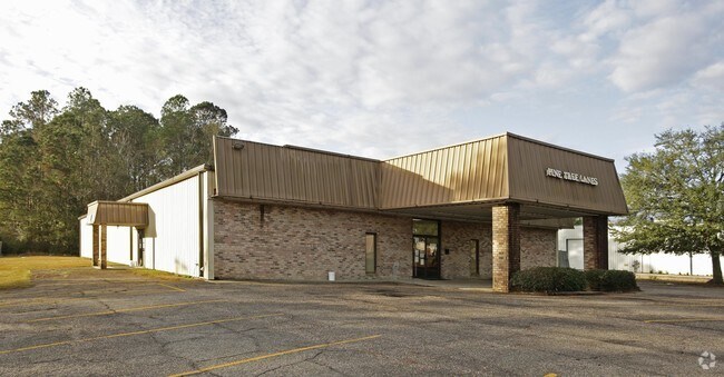
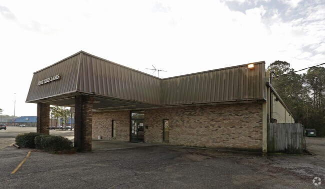
Property Record
426 S Memorial Blvd, Picayune, MS 39466
NEARBY LISTINGS FOR SALE OR LEASE
Property Detail
426 S Memorial Blvd
Storebuilding
1.80 AC IN NE1/4 NW1/4
X
Pearl River
28045C0095D
Mississippi
2025
1.80 AC
2024
Other Market Areas
950702
Picayune, MS
11,250 SF
6-17-6-23-002-040-0201
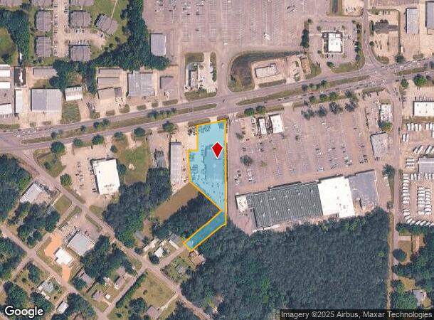
DEMOGRAPHICS near 426 S Memorial Blvd
1 Mile
3 Mile
5 Mile
2024 Total Population
3,405
14,434
22,442
2029 Population
3,573
15,027
23,316
Pop Growth 2024-2029
+ 4.93%
+ 4.11%
+ 3.89%
Average Age
38
40
41
2024 Total Households
1,409
5,853
9,001
HH Growth 2024-2029
+ 4.83%
+ 3.98%
+ 3.76%
Median Household Inc
$29,600
$37,630
$42,719
Avg Household Size
2.40
2.40
2.40
2024 Avg HH Vehicles
2.00
2.00
2.00
Median Home Value
$92,716
$120,595
$140,742
Median Year Built
1975
1979
1984
Nearby Places
Map Layers
Map Styles
 Street
 Aerial
- Restaurants
- Banks
- Shops
- Fitness
- Groceries
PUBLIC TRANSPORTATION
COMMUTER RAIL
Picayune Amtrak Station (Crescent - Amtrak)
DRIVE
WALK
Distance
Picayune Amtrak Station (Crescent - Amtrak)
1 min
17 min
0.9 mi
Freight Ports
Port of Gulf Port
DRIVE
WALK
Distance
Port of Gulf Port
67 min
49.4 mi
SALE & LEASE HISTORY
LISTING DATE
SALE/LEASE

Jan 23, 2017
For Sale
Nearby Properties
Address
Land Use
TOTAL SIZE
Lot Size
Zoning
Address
Land Use
TOTAL SIZE
Lot Size
Zoning
112,716 SF
28.68 AC
Address
Land Use
TOTAL SIZE
Lot Size
Zoning
36,353 SF
0.51 AC
Address
Land Use
TOTAL SIZE
Lot Size
Zoning
17,787 SF
4.61 AC
Address
Land Use
TOTAL SIZE
Lot Size
Zoning
33,696 SF
9.12 AC
Address
Land Use
TOTAL SIZE
Lot Size
Zoning
45,886 SF
2.12 AC
Address
Land Use
TOTAL SIZE
Lot Size
Zoning
16,704 SF
0.24 AC
Address
Land Use
TOTAL SIZE
Lot Size
Zoning
48,002 SF
2.57 AC
Address
Land Use
TOTAL SIZE
Lot Size
Zoning
24,000 SF
22.18 AC
Address
Land Use
TOTAL SIZE
Lot Size
Zoning
2,441 SF
125.10 AC
Address
Land Use
TOTAL SIZE
Lot Size
Zoning
55,428 SF
5.50 AC
Address
Land Use
TOTAL SIZE
Lot Size
Zoning
181,777 SF
24.60 AC
Address
Land Use
TOTAL SIZE
Lot Size
Zoning
40,140 SF
0.49 AC
Address
Land Use
TOTAL SIZE
Lot Size
Zoning
15,110 SF
2.62 AC
Address
Land Use
TOTAL SIZE
Lot Size
Zoning
17,724 SF
7.23 AC
Address
Land Use
TOTAL SIZE
Lot Size
Zoning
106,981 SF
21.70 AC
Address
Land Use
TOTAL SIZE
Lot Size
Zoning
62,918 SF
8.77 AC
Address
Land Use
TOTAL SIZE
Lot Size
Zoning
12,300 SF
1.85 AC
Address
Land Use
TOTAL SIZE
Lot Size
Zoning
6,329 SF
0.67 AC
Address
Land Use
TOTAL SIZE
Lot Size
Zoning
2,241 SF
13.63 AC
Address
Land Use
TOTAL SIZE
Lot Size
Zoning
7,589 SF
2.65 AC
Address
Land Use
TOTAL SIZE
Lot Size
Zoning
10,983 SF
2 AC
Address
Land Use
TOTAL SIZE
Lot Size
Zoning
3,900 SF
2.87 AC
Address
Land Use
TOTAL SIZE
Lot Size
Zoning
21,864 SF
0.99 AC
Address
Land Use
TOTAL SIZE
Lot Size
Zoning
8,880 SF
2.53 AC
Address
Land Use
TOTAL SIZE
Lot Size
Zoning
5,000 SF
16.50 AC
Address
Land Use
TOTAL SIZE
Lot Size
Zoning
3,650 SF
5.22 AC
Address
Land Use
TOTAL SIZE
Lot Size
Zoning
5,987 SF
9 AC
Address
Land Use
TOTAL SIZE
Lot Size
Zoning
9,450 SF
Address
Land Use
TOTAL SIZE
Lot Size
Zoning
7,049 SF
1.41 AC
Address
Land Use
TOTAL SIZE
Lot Size
Zoning
11,841 SF
2.64 AC
The World's #1 Commercial Real Estate Marketplace
Connect with us
© 2025 CoStar Group
The information above has been obtained from sources believed reliable. While we do not doubt its accuracy we have not verified it and make no guarantee, warranty or representation about it. It is your responsibility to independently confirm its accuracy and completeness. Any projections, opinions, assumptions, or estimates used are for example only and do not represent the current or future performance of the property. The value of this transaction to you depends on tax and other factors which should be evaluated by your tax, financial, and legal advisors. You and your advisors should conduct a careful, independent investigation of the property to determine to your satisfaction the suitability of the property for your needs.