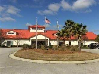
Property Record
426 Red Oaks Ln, Ridgeland, SC 29936


NEARBY LISTINGS FOR SALE OR LEASE
Property Detail
426 Red Oaks Ln
080-00-03-047
Okatie Area
Commercialnec
COUNTY (DISTRICT 04)
X
Jasper
45053C0410D
South Carolina
2025
6.31 AC
2025
I-95 Walterboro/Hardeeville
950201
Other Market Areas
980 SF
Hilton Head Island-Bluffton-Port Royal, SC
DEMOGRAPHICS near 426 Red Oaks Ln
1 Mile
3 Mile
5 Mile
2024 Total Population
974
12,506
34,888
2029 Population
1,208
15,168
40,177
Pop Growth 2024-2029
+ 24.02%
+ 21.29%
+ 15.16%
Average Age
51
53
53
2024 Total Households
458
5,849
15,762
HH Growth 2024-2029
+ 24.45%
+ 21.54%
+ 14.96%
Median Household Inc
$77,573
$77,861
$78,642
Avg Household Size
2.10
2.00
2.10
2024 Avg HH Vehicles
2.00
2.00
2.00
Median Home Value
$450,990
$428,874
$367,561
Median Year Built
2010
2007
2005
Nearby Places
Map Layers
Map Styles
 Street
 Aerial
- Restaurants
- Banks
- Shops
- Fitness
- Groceries
PUBLIC TRANSPORTATION
AIRPORT
Hilton Head
DRIVE
WALK
Distance
Hilton Head
29 min
19.7 mi
Savannah/Hilton Head International
DRIVE
WALK
Distance
Savannah/Hilton Head International
43 min
30.8 mi
Freight Ports
Georgia Ports - Savannah
DRIVE
WALK
Distance
Georgia Ports - Savannah
38 min
29.1 mi
Nearby Properties
Address
Land Use
TOTAL SIZE
Lot Size
Zoning
Address
Land Use
TOTAL SIZE
Lot Size
Zoning
17.80 AC
Address
Land Use
TOTAL SIZE
Lot Size
Zoning
896 SF
70.66 AC
Address
Land Use
TOTAL SIZE
Lot Size
Zoning
1,120 SF
5 AC
RC
Address
Land Use
TOTAL SIZE
Lot Size
Zoning
2.61 AC
RC
Address
Land Use
TOTAL SIZE
Lot Size
Zoning
1,248 SF
39.20 AC
PDD
Address
Land Use
TOTAL SIZE
Lot Size
Zoning
1,632 SF
18.20 AC
PDD
Address
Land Use
TOTAL SIZE
Lot Size
Zoning
1,632 SF
2.85 AC
PDD
Address
Land Use
TOTAL SIZE
Lot Size
Zoning
1,120 SF
5 AC
RC
Address
Land Use
TOTAL SIZE
Lot Size
Zoning
1,632 SF
5.42 AC
RA
Address
Land Use
TOTAL SIZE
Lot Size
Zoning
924 SF
17.76 AC
H2
Address
Land Use
TOTAL SIZE
Lot Size
Zoning
77,813 SF
22.12 AC
Address
Land Use
TOTAL SIZE
Lot Size
Zoning
188,132 SF
10.59 AC
Address
Land Use
TOTAL SIZE
Lot Size
Zoning
1,064 SF
29.45 AC
PDD
Address
Land Use
TOTAL SIZE
Lot Size
Zoning
980 SF
0.59 AC
RC
Address
Land Use
TOTAL SIZE
Lot Size
Zoning
67,941 SF
15.45 AC
Address
Land Use
TOTAL SIZE
Lot Size
Zoning
9,654 SF
23.27 AC
6106
Address
Land Use
TOTAL SIZE
Lot Size
Zoning
56,327 SF
50.02 AC
6616
Address
Land Use
TOTAL SIZE
Lot Size
Zoning
Address
Land Use
TOTAL SIZE
Lot Size
Zoning
7.22 AC
Address
Land Use
TOTAL SIZE
Lot Size
Zoning
7,700 SF
167.61 AC
FR
Address
Land Use
TOTAL SIZE
Lot Size
Zoning
81,625 SF
5.43 AC
Address
Land Use
TOTAL SIZE
Lot Size
Zoning
1,632 SF
172.10 AC
RA
Address
Land Use
TOTAL SIZE
Lot Size
Zoning
29,549 SF
17.88 AC
6106
Address
Land Use
TOTAL SIZE
Lot Size
Zoning
76,410 SF
27.89 AC
6616
Address
Land Use
TOTAL SIZE
Lot Size
Zoning
65,592 SF
3.33 AC
6606
Address
Land Use
TOTAL SIZE
Lot Size
Zoning
Address
Land Use
TOTAL SIZE
Lot Size
Zoning
3,296 SF
4.56 AC
PDD
Address
Land Use
TOTAL SIZE
Lot Size
Zoning
43,031 SF
5.92 AC
6606
The World's #1 Commercial Real Estate Marketplace
Connect with us
© 2026 CoStar Group
The information above has been obtained from sources believed reliable. While we do not doubt its accuracy we have not verified it and make no guarantee, warranty or representation about it. It is your responsibility to independently confirm its accuracy and completeness. Any projections, opinions, assumptions, or estimates used are for example only and do not represent the current or future performance of the property. The value of this transaction to you depends on tax and other factors which should be evaluated by your tax, financial, and legal advisors. You and your advisors should conduct a careful, independent investigation of the property to determine to your satisfaction the suitability of the property for your needs.