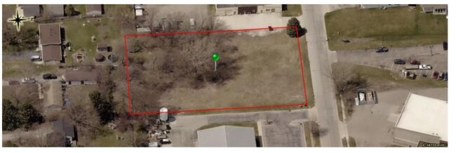
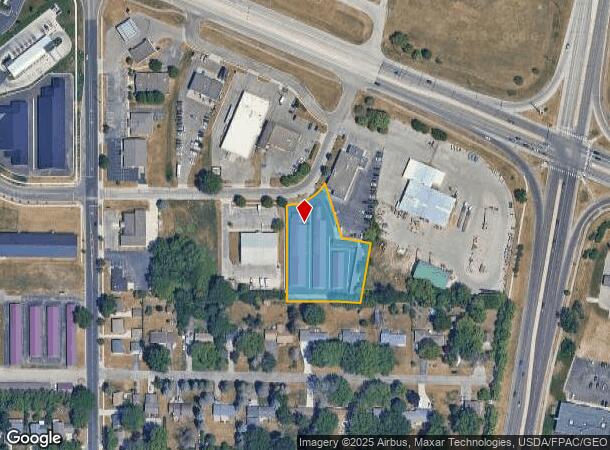
Property Record
426 Service Ct Ne, Rochester, MN 55906
NEARBY LISTINGS FOR SALE OR LEASE
Property Detail
426 Service Ct Ne
Rochester, MN
37Th St Business Park
74.24.23.056270
SECT-24 TWP-107 RANGE-014 37TH ST BUSINESS PARK LOT-002 BLOCK-002 1.26 AC TH PT LOT 2 BLK 2 DES AS FOL COM MOST ELY COR LOT 2
Publicstorage
Olmsted
X
Minnesota
27109C0162F
2
2025
1.26 AC
2024
Rochester
001601
Other Market Areas
22,686 SF
DEMOGRAPHICS near 426 Service Ct Ne
1 Mile
3 Mile
5 Mile
2024 Total Population
6,960
61,095
116,837
2029 Population
7,090
62,498
119,887
Pop Growth 2024-2029
+ 1.87%
+ 2.30%
+ 2.61%
Average Age
41
40
39
2024 Total Households
2,842
26,806
48,359
HH Growth 2024-2029
+ 1.79%
+ 2.44%
+ 2.63%
Median Household Inc
$89,691
$71,907
$79,382
Avg Household Size
2.40
2.20
2.30
2024 Avg HH Vehicles
2.00
2.00
2.00
Median Home Value
$273,194
$264,194
$273,914
Median Year Built
1979
1979
1985
Nearby Places
Map Layers
Map Styles
 Street
 Aerial
- Restaurants
- Banks
- Shops
- Fitness
- Groceries
PUBLIC TRANSPORTATION
AIRPORT
Rochester International
DRIVE
WALK
Distance
Rochester International
20 min
13.2 mi
Freight Ports
Port Milwaukee
DRIVE
WALK
Distance
Port Milwaukee
311 min
279.2 mi
SALE & LEASE HISTORY
LISTING DATE
SALE/LEASE

May 03, 2017
For Sale
Jun 16, 2020
For Lease
Nearby Properties
Address
Land Use
TOTAL SIZE
Lot Size
Zoning
Address
Land Use
TOTAL SIZE
Lot Size
Zoning
Address
Land Use
TOTAL SIZE
Lot Size
Zoning
2,238,362 SF
2.06 AC
Address
Land Use
TOTAL SIZE
Lot Size
Zoning
2.77 AC
Address
Land Use
TOTAL SIZE
Lot Size
Zoning
791,669 SF
2.15 AC
Address
Land Use
TOTAL SIZE
Lot Size
Zoning
37,242 SF
1.06 AC
Address
Land Use
TOTAL SIZE
Lot Size
Zoning
454,243 SF
3.92 AC
Address
Land Use
TOTAL SIZE
Lot Size
Zoning
443,223 SF
4.44 AC
Address
Land Use
TOTAL SIZE
Lot Size
Zoning
448,296 SF
1.21 AC
Address
Land Use
TOTAL SIZE
Lot Size
Zoning
960 SF
38.12 AC
Address
Land Use
TOTAL SIZE
Lot Size
Zoning
45.84 AC
Address
Land Use
TOTAL SIZE
Lot Size
Zoning
1,836 SF
80.90 AC
Address
Land Use
TOTAL SIZE
Lot Size
Zoning
339,724 SF
0.56 AC
Address
Land Use
TOTAL SIZE
Lot Size
Zoning
0.88 AC
Address
Land Use
TOTAL SIZE
Lot Size
Zoning
13,946 SF
34.10 AC
Address
Land Use
TOTAL SIZE
Lot Size
Zoning
309,127 SF
0.67 AC
Address
Land Use
TOTAL SIZE
Lot Size
Zoning
175,078 SF
1.98 AC
Address
Land Use
TOTAL SIZE
Lot Size
Zoning
98,878 SF
0.89 AC
Address
Land Use
TOTAL SIZE
Lot Size
Zoning
159,238 SF
0.65 AC
Address
Land Use
TOTAL SIZE
Lot Size
Zoning
423,328 SF
1.89 AC
Address
Land Use
TOTAL SIZE
Lot Size
Zoning
192,929 SF
1.12 AC
Address
Land Use
TOTAL SIZE
Lot Size
Zoning
Address
Land Use
TOTAL SIZE
Lot Size
Zoning
210,691 SF
34.19 AC
Address
Land Use
TOTAL SIZE
Lot Size
Zoning
61,632 SF
53.25 AC
Address
Land Use
TOTAL SIZE
Lot Size
Zoning
53.73 AC
Address
Land Use
TOTAL SIZE
Lot Size
Zoning
167.09 AC
Address
Land Use
TOTAL SIZE
Lot Size
Zoning
4.63 AC
Address
Land Use
TOTAL SIZE
Lot Size
Zoning
250,864 SF
4.43 AC
Address
Land Use
TOTAL SIZE
Lot Size
Zoning
9.01 AC
Address
Land Use
TOTAL SIZE
Lot Size
Zoning
122,460 SF
0.33 AC
Address
Land Use
TOTAL SIZE
Lot Size
Zoning
6,780 SF
1.16 AC
The World's #1 Commercial Real Estate Marketplace
Connect with us
© 2025 CoStar Group
The information above has been obtained from sources believed reliable. While we do not doubt its accuracy we have not verified it and make no guarantee, warranty or representation about it. It is your responsibility to independently confirm its accuracy and completeness. Any projections, opinions, assumptions, or estimates used are for example only and do not represent the current or future performance of the property. The value of this transaction to you depends on tax and other factors which should be evaluated by your tax, financial, and legal advisors. You and your advisors should conduct a careful, independent investigation of the property to determine to your satisfaction the suitability of the property for your needs.