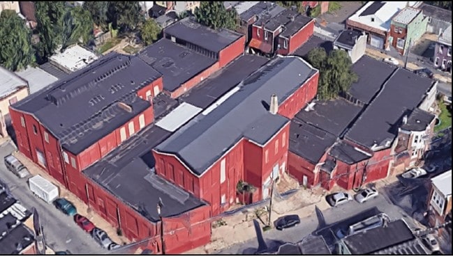
Property Record
1822 Church Ln, Philadelphia, PA 19141
Current Lease Availabilities
NEARBY LISTINGS FOR SALE OR LEASE
Property Detail
1822 Church Ln
171235000
226
Townhouserowhouse
Philadelphia
X
Pennsylvania
42091C0395G
226
2024
0.03 AC
2026
Northeast Philly
029400
Philadelphia
1,234 SF
Philadelphia-Camden-Wilmington, PA-NJ-DE-MD
DEMOGRAPHICS near 1822 Church Ln
1 Mile
3 Mile
5 Mile
2024 Total Population
37,638
325,432
803,206
2029 Population
35,911
311,207
780,365
Pop Growth 2024-2029
(4.59%)
(4.37%)
(2.84%)
Average Age
36
36
37
2024 Total Households
13,360
113,538
297,869
HH Growth 2024-2029
(4.85%)
(4.54%)
(2.96%)
Median Household Inc
$33,941
$43,173
$47,241
Avg Household Size
2.70
2.80
2.60
2024 Avg HH Vehicles
1.00
1.00
1.00
Median Home Value
$134,683
$152,263
$178,887
Median Year Built
1946
1948
1949
Nearby Places
- Restaurants
- Banks
- Shops
- Fitness
- Groceries
PUBLIC TRANSPORTATION
TRANSIT/SUBWAY
Olney (Broad Street Line - SEPTA)
DRIVE
WALK
Distance
Olney (Broad Street Line - SEPTA)
2 min
15 min
0.8 mi
Fern Rock Transportation Center (Broad Street Line - SEPTA)
DRIVE
WALK
Distance
Fern Rock Transportation Center (Broad Street Line - SEPTA)
4 min
18 min
0.9 mi
COMMUTER RAIL
Wister (R7 - Southeastern Pennsylvania Transportation Authority Regional Rail (SEPTA Regional Rail))
DRIVE
WALK
Distance
Wister (R7 - Southeastern Pennsylvania Transportation Authority Regional Rail (SEPTA Regional Rail))
4 min
1.3 mi
Fern Rock Transportation Center (Lansdale/Doylestown Line - SEPTA, R1 - SEPTA, R2 - SEPTA, R3 - SEPTA, R5 - SEPTA, Warminster Line - SEPTA, West Trenton Line - SEPTA)
DRIVE
WALK
Distance
Fern Rock Transportation Center (Lansdale/Doylestown Line - SEPTA, R1 - SEPTA, R2 - SEPTA, R3 - SEPTA, R5 - SEPTA, Warminster Line - SEPTA, West Trenton Line - SEPTA)
5 min
1.8 mi
AIRPORT
Philadelphia International
DRIVE
WALK
Distance
Philadelphia International
33 min
18.4 mi
Trenton Mercer
DRIVE
WALK
Distance
Trenton Mercer
48 min
29.0 mi
Freight Ports
Port of Philadelphia
DRIVE
WALK
Distance
Port of Philadelphia
14 min
7.9 mi
Nearby Properties
Address
Land Use
TOTAL SIZE
Lot Size
Zoning
Address
Land Use
TOTAL SIZE
Lot Size
Zoning
638,776 SF
20 AC
RM2
Address
Land Use
TOTAL SIZE
Lot Size
Zoning
455,889 SF
33 AC
I2
Address
Land Use
TOTAL SIZE
Lot Size
Zoning
520,280 SF
14.84 AC
RM3
Address
Land Use
TOTAL SIZE
Lot Size
Zoning
2,146,150 SF
119.95 AC
M1
Address
Land Use
TOTAL SIZE
Lot Size
Zoning
22,648 SF
38.69 AC
RM3
Address
Land Use
TOTAL SIZE
Lot Size
Zoning
485,616 SF
8.96 AC
CMX3
Address
Land Use
TOTAL SIZE
Lot Size
Zoning
242,655 SF
3.29 AC
CMX3
Address
Land Use
TOTAL SIZE
Lot Size
Zoning
425,535 SF
4.60 AC
RM3
Address
Land Use
TOTAL SIZE
Lot Size
Zoning
3,590 SF
50 AC
SPPOA
Address
Land Use
TOTAL SIZE
Lot Size
Zoning
121,578 SF
3.13 AC
RSA3
Address
Land Use
TOTAL SIZE
Lot Size
Zoning
587,330 SF
34.37 AC
SPINS
Address
Land Use
TOTAL SIZE
Lot Size
Zoning
287,286 SF
1.26 AC
CMX5
Address
Land Use
TOTAL SIZE
Lot Size
Zoning
17,886 SF
80 AC
SPPOA
Address
Land Use
TOTAL SIZE
Lot Size
Zoning
504,972 SF
16.30 AC
RM2
Address
Land Use
TOTAL SIZE
Lot Size
Zoning
500,000 SF
2.30 AC
CMX3
Address
Land Use
TOTAL SIZE
Lot Size
Zoning
218,030 SF
23.75 AC
CA2
Address
Land Use
TOTAL SIZE
Lot Size
Zoning
238,378 SF
18 AC
CA1
Address
Land Use
TOTAL SIZE
Lot Size
Zoning
75,358 SF
24.98 AC
I2
Address
Land Use
TOTAL SIZE
Lot Size
Zoning
237,834 SF
0.96 AC
CMX3
Address
Land Use
TOTAL SIZE
Lot Size
Zoning
210,964 SF
21.28 AC
CMX3
Address
Land Use
TOTAL SIZE
Lot Size
Zoning
300 AC
RSD1
Address
Land Use
TOTAL SIZE
Lot Size
Zoning
249,388 SF
8.08 AC
RSA5
Address
Land Use
TOTAL SIZE
Lot Size
Zoning
363,136 SF
16.47 AC
RSA3
Address
Land Use
TOTAL SIZE
Lot Size
Zoning
233,143 SF
24.24 AC
SPINS
Address
Land Use
TOTAL SIZE
Lot Size
Zoning
180,000 SF
13.30 AC
CMX3
Address
Land Use
TOTAL SIZE
Lot Size
Zoning
329,300 SF
6.98 AC
RSA5
Address
Land Use
TOTAL SIZE
Lot Size
Zoning
281,012 SF
32.58 AC
RSA5
Address
Land Use
TOTAL SIZE
Lot Size
Zoning
389,736 SF
3.15 AC
CMX3
Address
Land Use
TOTAL SIZE
Lot Size
Zoning
148,293 SF
7.45 AC
RM2
Address
Land Use
TOTAL SIZE
Lot Size
Zoning
705,687 SF
19.89 AC
C1
The World's #1 Commercial Real Estate Marketplace
Connect with us
© 2025 CoStar Group
The information above has been obtained from sources believed reliable. While we do not doubt its accuracy we have not verified it and make no guarantee, warranty or representation about it. It is your responsibility to independently confirm its accuracy and completeness. Any projections, opinions, assumptions, or estimates used are for example only and do not represent the current or future performance of the property. The value of this transaction to you depends on tax and other factors which should be evaluated by your tax, financial, and legal advisors. You and your advisors should conduct a careful, independent investigation of the property to determine to your satisfaction the suitability of the property for your needs.