Property Record
4261 Reno Hwy, Fallon, NV 89406
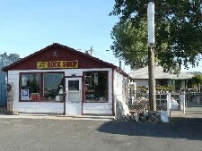


Property Detail
4261 Reno Hwy
008-461-47
PARCEL IN SW1/4-NE1/4,COM AT NE COR,TH S49*3635W A DIST OF 2157.12 FT, TH N89*50E A DIST OF 81.0 FT TO POB.,TH S00*23E A DIST OF 600.0 FT, TH S89*50W A DIST OF 81.0 FT, TH N00*23W A DIST OF 356.07 FT, TH S89*50W A DIST OF 91.25 FT, TH N00*23W A DIST
Commercialnec
Churchill
C1;TR RES/
Nevada
B and X Area of moderate flood hazard, usually the area between the limits of the 100-year and 500-year floods.
1.54 AC
2024
Outer Churchill County
2025
Reno/Sparks
950700
Fallon, NV
2,616 SF
NEARBY LISTINGS FOR SALE OR LEASE
DEMOGRAPHICS near 4261 Reno Hwy
1 mile
3 mile
5 mile
2025 Total Population
1,798
9,538
20,849
2030 Population
1,823
9,656
21,167
Pop Growth 2025-2030
+ 1.39%
+ 1.24%
+ 1.53%
Average Age
42
43
42
2025 Total Households
651
3,614
8,321
HH Growth 2025-2030
+ 1.38%
+ 1.25%
+ 1.59%
Median Household Inc
$79,215
$87,654
$73,878
Avg Household Size
2.70
2.60
2.40
2025 Avg HH Vehicles
3.00
3.00
2.00
Median Home Value
$336,805
$341,325
$322,292
Median Year Built
1993
1990
1987
Nearby Places
Map Layers
Map Styles
 Street
 Aerial
Layers
 Traffic
 Biking
Places
Listings with unknown addresses are not visible on the map
- Restaurants
- Banks
- Shops
- Fitness
- Groceries
Nearby Properties
Address
Land Use
TOTAL SIZE
Lot Size
Zoning
Address
Land Use
TOTAL SIZE
Lot Size
Zoning
200,656 SF
21.53 AC
C1;TR RES/
Address
Land Use
TOTAL SIZE
Lot Size
Zoning
63,187 SF
2.51 AC
C2;GENERAL
Address
Land Use
TOTAL SIZE
Lot Size
Zoning
46,041 SF
12.19 AC
I
Address
Land Use
TOTAL SIZE
Lot Size
Zoning
63,020 SF
5.52 AC
C2
Address
Land Use
TOTAL SIZE
Lot Size
Zoning
14,632 SF
1.06 AC
C1
Address
Land Use
TOTAL SIZE
Lot Size
Zoning
3,127 SF
2.03 AC
R1;SFR 1HS
Address
Land Use
TOTAL SIZE
Lot Size
Zoning
44,189 SF
3.76 AC
C2
Address
Land Use
TOTAL SIZE
Lot Size
Zoning
39,028 SF
2 AC
C2;GENERAL
Address
Land Use
TOTAL SIZE
Lot Size
Zoning
14,739 SF
3.18 AC
C2;GENERAL
Address
Land Use
TOTAL SIZE
Lot Size
Zoning
51,136 SF
2.87 AC
C2;GENERAL
Address
Land Use
TOTAL SIZE
Lot Size
Zoning
5,172 SF
26.01 AC
A5
Address
Land Use
TOTAL SIZE
Lot Size
Zoning
18,406 SF
2.80 AC
C2
Address
Land Use
TOTAL SIZE
Lot Size
Zoning
7,102 SF
2.50 AC
R2
Address
Land Use
TOTAL SIZE
Lot Size
Zoning
1,161 SF
1.80 AC
C2;GENERAL
Address
Land Use
TOTAL SIZE
Lot Size
Zoning
63,031 SF
7.55 AC
C1;TR RES/
Address
Land Use
TOTAL SIZE
Lot Size
Zoning
3,336 SF
1.02 AC
C2
Address
Land Use
TOTAL SIZE
Lot Size
Zoning
18,484 SF
1.39 AC
C2;GENERAL
Address
Land Use
TOTAL SIZE
Lot Size
Zoning
24,439 SF
1.02 AC
C1;TR RES/
Address
Land Use
TOTAL SIZE
Lot Size
Zoning
28,326 SF
3.09 AC
RC;RES COM
Address
Land Use
TOTAL SIZE
Lot Size
Zoning
56,532 SF
34.15 AC
A5
Address
Land Use
TOTAL SIZE
Lot Size
Zoning
24,384 SF
0.68 AC
C1
Address
Land Use
TOTAL SIZE
Lot Size
Zoning
14,632 SF
2.06 AC
C1
Address
Land Use
TOTAL SIZE
Lot Size
Zoning
7,601 SF
1 AC
C1;TR RES/
Address
Land Use
TOTAL SIZE
Lot Size
Zoning
11,604 SF
2.18 AC
C1;TR RES/
Address
Land Use
TOTAL SIZE
Lot Size
Zoning
3,852 SF
2.70 AC
C2;GENERAL
Address
Land Use
TOTAL SIZE
Lot Size
Zoning
4,625 SF
15.70 AC
C2;GENERAL
Address
Land Use
TOTAL SIZE
Lot Size
Zoning
5,762 SF
1.36 AC
C2;GENERAL
Address
Land Use
TOTAL SIZE
Lot Size
Zoning
5,059 SF
80 AC
A5
Address
Land Use
TOTAL SIZE
Lot Size
Zoning
22,352 SF
2.19 AC
C1;TR RES/
Address
Land Use
TOTAL SIZE
Lot Size
Zoning
3,936 SF
0.81 AC
C2;GENERAL
The World's #1 Commercial Real Estate Marketplace
Connect with us
© 2026 CoStar Group
The information above has been obtained from sources believed reliable. While we do not doubt its accuracy we have not verified it and make no guarantee, warranty or representation about it. It is your responsibility to independently confirm its accuracy and completeness. Any projections, opinions, assumptions, or estimates used are for example only and do not represent the current or future performance of the property. The value of this transaction to you depends on tax and other factors which should be evaluated by your tax, financial, and legal advisors. You and your advisors should conduct a careful, independent investigation of the property to determine to your satisfaction the suitability of the property for your needs.