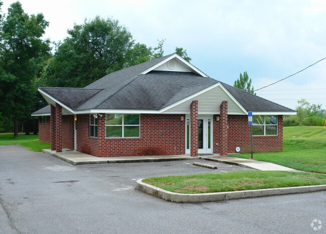
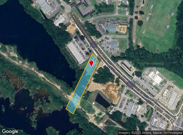
Property Record
4263 Woodbine Rd, Milton, FL 32571

NEARBY LISTINGS FOR SALE OR LEASE
Property Detail
4263 Woodbine Rd
22-1N-29-0000-00133-0000
COM NW COR TH S3*8 29 E 2191.1 2 FT TH S23*829E 512 FT TH N47*13E 1080.39 FT TH S54* 4330E 2061.34 FT TO POB TH N26*331E 581.37 FT TO SWL Y R/W OF WOODBINE RD TH SELY ON CURVED R/W 109.65 FT (R=2914.93,CB=S39*1412E) & SWLY R/W OF 200 WIDE GP CO ESMNT
Medicalbuilding
Santa Rosa
AE
Florida
12113C0408H
1.56 AC
2024
Gonzalez/SW Santa Rosa
2025
Pensacola
010707
Pensacola-Ferry Pass-Brent, FL
2,468 SF
DEMOGRAPHICS near 4263 Woodbine Rd
1 Mile
3 Mile
5 Mile
2024 Total Population
1,812
14,655
47,823
2029 Population
2,059
16,750
53,664
Pop Growth 2024-2029
+ 13.63%
+ 14.30%
+ 12.21%
Average Age
40
39
40
2024 Total Households
668
5,442
17,498
HH Growth 2024-2029
+ 14.07%
+ 14.59%
+ 12.37%
Median Household Inc
$81,707
$71,639
$74,546
Avg Household Size
2.70
2.70
2.60
2024 Avg HH Vehicles
2.00
2.00
2.00
Median Home Value
$246,132
$246,248
$262,147
Median Year Built
1989
1991
1995
Nearby Places
Map Layers
Map Styles
 Street
 Aerial
- Restaurants
- Banks
- Shops
- Fitness
- Groceries
PUBLIC TRANSPORTATION
AIRPORT
Pensacola International
DRIVE
WALK
Distance
Pensacola International
21 min
11.6 mi
Freight Ports
Port of Mobile
DRIVE
WALK
Distance
Port of Mobile
72 min
60.5 mi
Nearby Properties
Address
Land Use
TOTAL SIZE
Lot Size
Zoning
Address
Land Use
TOTAL SIZE
Lot Size
Zoning
47.05 AC
AG-RR
Address
Land Use
TOTAL SIZE
Lot Size
Zoning
81,123 SF
8.78 AC
HCD
Address
Land Use
TOTAL SIZE
Lot Size
Zoning
60,129 SF
0.11 AC
HCD
Address
Land Use
TOTAL SIZE
Lot Size
Zoning
13.70 AC
HCD
Address
Land Use
TOTAL SIZE
Lot Size
Zoning
76,674 SF
2.80 AC
HCD
Address
Land Use
TOTAL SIZE
Lot Size
Zoning
93,476 SF
7.43 AC
HCD
Address
Land Use
TOTAL SIZE
Lot Size
Zoning
389.54 AC
AG-RR
Address
Land Use
TOTAL SIZE
Lot Size
Zoning
112,196 SF
343.01 AC
HCD
Address
Land Use
TOTAL SIZE
Lot Size
Zoning
50,616 SF
2.56 AC
R3
Address
Land Use
TOTAL SIZE
Lot Size
Zoning
30,564 SF
11.12 AC
HCD
Address
Land Use
TOTAL SIZE
Lot Size
Zoning
23,668 SF
2.30 AC
HCD
Address
Land Use
TOTAL SIZE
Lot Size
Zoning
13,560 SF
5.93 AC
HCD
Address
Land Use
TOTAL SIZE
Lot Size
Zoning
45,485 SF
6.49 AC
HCD
Address
Land Use
TOTAL SIZE
Lot Size
Zoning
62,174 SF
4 AC
HCD
Address
Land Use
TOTAL SIZE
Lot Size
Zoning
63,181 SF
6.61 AC
R2
Address
Land Use
TOTAL SIZE
Lot Size
Zoning
40,250 SF
2.19 AC
HCD
Address
Land Use
TOTAL SIZE
Lot Size
Zoning
35,878 SF
10 AC
HCD
Address
Land Use
TOTAL SIZE
Lot Size
Zoning
198,945 SF
358 AC
M2
Address
Land Use
TOTAL SIZE
Lot Size
Zoning
16,596 SF
1.29 AC
HCD
Address
Land Use
TOTAL SIZE
Lot Size
Zoning
27,839 SF
4 AC
AG-RR
Address
Land Use
TOTAL SIZE
Lot Size
Zoning
15,573 SF
1.65 AC
HCD
Address
Land Use
TOTAL SIZE
Lot Size
Zoning
16,675 SF
2 AC
HCD
Address
Land Use
TOTAL SIZE
Lot Size
Zoning
41,800 SF
3.81 AC
HCD
Address
Land Use
TOTAL SIZE
Lot Size
Zoning
24,061 SF
1.95 AC
HCD
Address
Land Use
TOTAL SIZE
Lot Size
Zoning
26,310 SF
120 AC
AG-RR
Address
Land Use
TOTAL SIZE
Lot Size
Zoning
13,974 SF
1.76 AC
HCD
Address
Land Use
TOTAL SIZE
Lot Size
Zoning
6,452 SF
4.82 AC
HCD
Address
Land Use
TOTAL SIZE
Lot Size
Zoning
2,324 SF
19.68 AC
HCD
Address
Land Use
TOTAL SIZE
Lot Size
Zoning
12,333 SF
3.67 AC
HCD
The World's #1 Commercial Real Estate Marketplace
Connect with us
© 2025 CoStar Group
The information above has been obtained from sources believed reliable. While we do not doubt its accuracy we have not verified it and make no guarantee, warranty or representation about it. It is your responsibility to independently confirm its accuracy and completeness. Any projections, opinions, assumptions, or estimates used are for example only and do not represent the current or future performance of the property. The value of this transaction to you depends on tax and other factors which should be evaluated by your tax, financial, and legal advisors. You and your advisors should conduct a careful, independent investigation of the property to determine to your satisfaction the suitability of the property for your needs.