Property Record
4264 Destiny Dr, Holland, MI 49423
NEARBY LISTINGS FOR SALE OR LEASE
-
-
View all Holland listings for sale on LoopNet.com
Property Detail
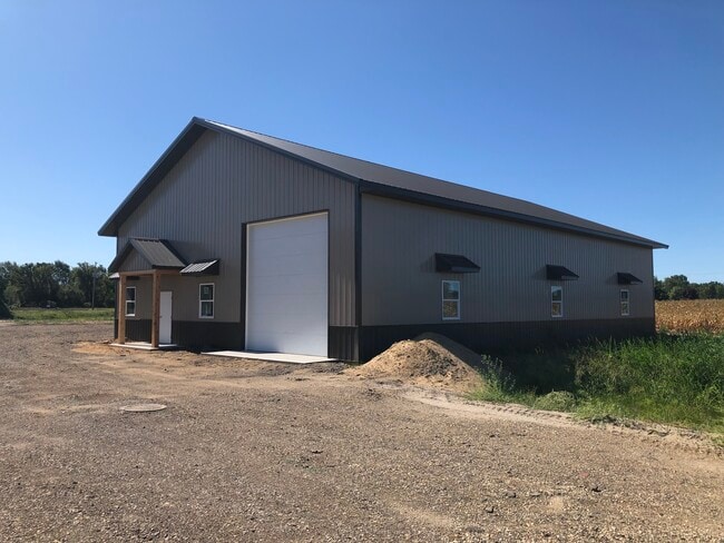
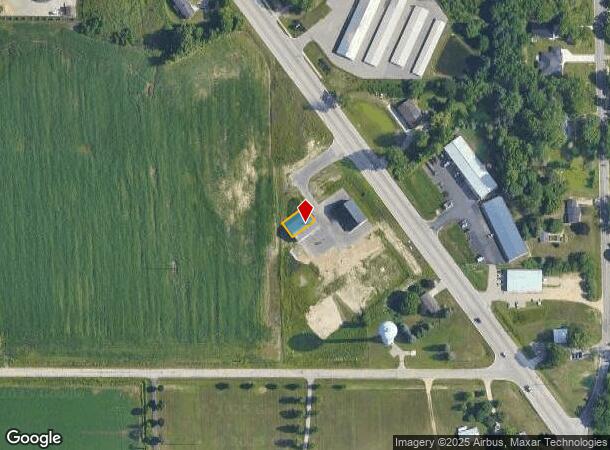
4264 Destiny Dr
Holland, MI
Love's Business Park
06-475-001-00
UNIT 1 LOVE'S BUSINESS PARK CONDO SEC 15 T4N R15W (2023). SPLIT/COMBINED ON 07/05/2022 FROM 06-015-007-02;
Autorepair
Allegan
2024
Michigan
2025
Outlying Allegan County
032401
West Michigan
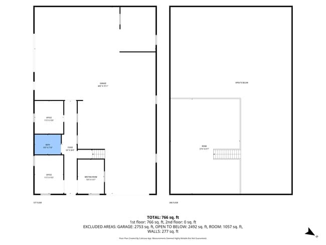
3,700 SF
DEMOGRAPHICS near 4264 Destiny Dr
1 Mile
3 Mile
5 Mile
2024 Total Population
1,020
3,645
40,414
2029 Population
1,065
3,759
41,838
Pop Growth 2024-2029
+ 4.41%
+ 3.13%
+ 3.52%
Average Age
37
38
38
2024 Total Households
378
1,321
14,621
HH Growth 2024-2029
+ 4.23%
+ 3.10%
+ 3.58%
Median Household Inc
$61,667
$67,619
$70,718
Avg Household Size
2.70
2.70
2.50
2024 Avg HH Vehicles
2.00
2.00
2.00
Median Home Value
$212,644
$240,710
$230,202
Median Year Built
1990
1986
1976
Nearby Places
Map Layers
Map Styles
 Street
 Aerial
- Restaurants
- Banks
- Shops
- Fitness
- Groceries
PUBLIC TRANSPORTATION
COMMUTER RAIL
Holland Amtrak Station (Pere Marquette - Amtrak)
DRIVE
WALK
Distance
Holland Amtrak Station (Pere Marquette - Amtrak)
9 min
5.4 mi
AIRPORT
Gerald R Ford International
DRIVE
WALK
Distance
Gerald R Ford International
43 min
34.9 mi
Freight Ports
Port Milwaukee
DRIVE
WALK
Distance
Port Milwaukee
275 min
235.9 mi
SALE & LEASE HISTORY
LISTING DATE
SALE/LEASE

Sep 10, 2021
For Sale
Nearby Properties
Address
Land Use
TOTAL SIZE
Lot Size
Zoning
Address
Land Use
TOTAL SIZE
Lot Size
Zoning
1,599,294 SF
Address
Land Use
TOTAL SIZE
Lot Size
Zoning
1,788,352 SF
173.33 AC
Address
Land Use
TOTAL SIZE
Lot Size
Zoning
682,378 SF
99.60 AC
NA
Address
Land Use
TOTAL SIZE
Lot Size
Zoning
198,712 SF
Address
Land Use
TOTAL SIZE
Lot Size
Zoning
630,943 SF
28.50 AC
Address
Land Use
TOTAL SIZE
Lot Size
Zoning
674,052 SF
79.30 AC
Address
Land Use
TOTAL SIZE
Lot Size
Zoning
154,107 SF
Address
Land Use
TOTAL SIZE
Lot Size
Zoning
239,465 SF
Address
Land Use
TOTAL SIZE
Lot Size
Zoning
118,444 SF
4.39 AC
Address
Land Use
TOTAL SIZE
Lot Size
Zoning
150,822 SF
Address
Land Use
TOTAL SIZE
Lot Size
Zoning
391,842 SF
28.34 AC
Address
Land Use
TOTAL SIZE
Lot Size
Zoning
357,000 SF
23.35 AC
Address
Land Use
TOTAL SIZE
Lot Size
Zoning
73,700 SF
Address
Land Use
TOTAL SIZE
Lot Size
Zoning
397,258 SF
36.66 AC
I2
Address
Land Use
TOTAL SIZE
Lot Size
Zoning
158,661 SF
17.28 AC
Address
Land Use
TOTAL SIZE
Lot Size
Zoning
146,357 SF
20.04 AC
Address
Land Use
TOTAL SIZE
Lot Size
Zoning
73,663 SF
4.66 AC
Address
Land Use
TOTAL SIZE
Lot Size
Zoning
252,065 SF
13.98 AC
Address
Land Use
TOTAL SIZE
Lot Size
Zoning
404,600 SF
23.23 AC
I2
Address
Land Use
TOTAL SIZE
Lot Size
Zoning
132,108 SF
9.97 AC
I-1
Address
Land Use
TOTAL SIZE
Lot Size
Zoning
281,775 SF
Address
Land Use
TOTAL SIZE
Lot Size
Zoning
55,088 SF
Address
Land Use
TOTAL SIZE
Lot Size
Zoning
300,000 SF
Address
Land Use
TOTAL SIZE
Lot Size
Zoning
140,700 SF
20.28 AC
Address
Land Use
TOTAL SIZE
Lot Size
Zoning
70,766 SF
3.56 AC
Address
Land Use
TOTAL SIZE
Lot Size
Zoning
336,292 SF
15.15 AC
I2
Address
Land Use
TOTAL SIZE
Lot Size
Zoning
308,687 SF
13.83 AC
Address
Land Use
TOTAL SIZE
Lot Size
Zoning
88.36 AC
Address
Land Use
TOTAL SIZE
Lot Size
Zoning
218,946 SF
20.50 AC
I2
Address
Land Use
TOTAL SIZE
Lot Size
Zoning
52,832 SF
The World's #1 Commercial Real Estate Marketplace
Connect with us
© 2025 CoStar Group
The information above has been obtained from sources believed reliable. While we do not doubt its accuracy we have not verified it and make no guarantee, warranty or representation about it. It is your responsibility to independently confirm its accuracy and completeness. Any projections, opinions, assumptions, or estimates used are for example only and do not represent the current or future performance of the property. The value of this transaction to you depends on tax and other factors which should be evaluated by your tax, financial, and legal advisors. You and your advisors should conduct a careful, independent investigation of the property to determine to your satisfaction the suitability of the property for your needs.