Property Record
42685 State Route 12, Alexandria Bay, NY 13607


NEARBY LISTINGS FOR SALE OR LEASE
-
-
View all Alexandria Bay listings for sale on LoopNet.com
Property Detail
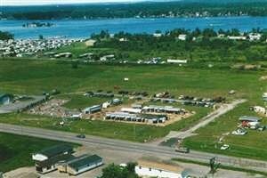
42685 State Route 12
224600-013-010-0001-028-832
Jefferson
Industrialgeneral
New York
ARE
28.832
36045C0111G
8.46 AC
2025
Jefferson County
2024
Syracuse
060201
Watertown-Fort Drum, NY
6,600 SF
DEMOGRAPHICS near 42685 State Route 12
1 Mile
3 Mile
5 Mile
2024 Total Population
167
1,420
3,936
2029 Population
168
1,471
4,063
Pop Growth 2024-2029
+ 0.60%
+ 3.59%
+ 3.23%
Average Age
56
51
48
2024 Total Households
81
686
1,896
HH Growth 2024-2029
0.00%
+ 3.79%
+ 3.48%
Median Household Inc
$108,333
$76,580
$70,746
Avg Household Size
2.10
2.00
2.00
2024 Avg HH Vehicles
2.00
2.00
2.00
Median Home Value
$281,034
$318,531
$264,999
Median Year Built
1949
1975
1974
Nearby Places
Map Layers
Map Styles
 Street
 Aerial
- Restaurants
- Banks
- Shops
- Fitness
- Groceries
Nearby Properties
Address
Land Use
TOTAL SIZE
Lot Size
Zoning
Address
Land Use
TOTAL SIZE
Lot Size
Zoning
3,256 SF
49.60 AC
RE
Address
Land Use
TOTAL SIZE
Lot Size
Zoning
4.30 AC
Address
Land Use
TOTAL SIZE
Lot Size
Zoning
1,088 SF
27.87 AC
05 - COMME
Address
Land Use
TOTAL SIZE
Lot Size
Zoning
19,077 SF
270.80 AC
Address
Land Use
TOTAL SIZE
Lot Size
Zoning
69.10 AC
07 - MIXED
Address
Land Use
TOTAL SIZE
Lot Size
Zoning
396 SF
50.10 AC
B
Address
Land Use
TOTAL SIZE
Lot Size
Zoning
Address
Land Use
TOTAL SIZE
Lot Size
Zoning
42,507 SF
13.69 AC
B
Address
Land Use
TOTAL SIZE
Lot Size
Zoning
952 SF
46.10 AC
07 - MIXED
Address
Land Use
TOTAL SIZE
Lot Size
Zoning
980 SF
119 AC
AR
Address
Land Use
TOTAL SIZE
Lot Size
Zoning
800 SF
13.50 AC
B
Address
Land Use
TOTAL SIZE
Lot Size
Zoning
8,091 SF
5.10 AC
08 - GOVER
Address
Land Use
TOTAL SIZE
Lot Size
Zoning
25.40 AC
Address
Land Use
TOTAL SIZE
Lot Size
Zoning
744 SF
12.30 AC
AB
Address
Land Use
TOTAL SIZE
Lot Size
Zoning
1,056 SF
40.40 AC
Address
Land Use
TOTAL SIZE
Lot Size
Zoning
672 SF
15.26 AC
Address
Land Use
TOTAL SIZE
Lot Size
Zoning
980 SF
9.10 AC
07 - MIXED
Address
Land Use
TOTAL SIZE
Lot Size
Zoning
Address
Land Use
TOTAL SIZE
Lot Size
Zoning
1,200 SF
2 AC
RES1
Address
Land Use
TOTAL SIZE
Lot Size
Zoning
Address
Land Use
TOTAL SIZE
Lot Size
Zoning
2,020 SF
1.40 AC
RE
Address
Land Use
TOTAL SIZE
Lot Size
Zoning
9,380 SF
7.35 AC
AB
Address
Land Use
TOTAL SIZE
Lot Size
Zoning
161 SF
4.80 AC
Address
Land Use
TOTAL SIZE
Lot Size
Zoning
552 SF
7.60 AC
MR
Address
Land Use
TOTAL SIZE
Lot Size
Zoning
4,938 SF
2.25 AC
Address
Land Use
TOTAL SIZE
Lot Size
Zoning
1,988 SF
25.74 AC
Address
Land Use
TOTAL SIZE
Lot Size
Zoning
7,148 SF
39.80 AC
MD
Address
Land Use
TOTAL SIZE
Lot Size
Zoning
408 SF
3.60 AC
MD
Address
Land Use
TOTAL SIZE
Lot Size
Zoning
8,355 SF
21.60 AC
B
Address
Land Use
TOTAL SIZE
Lot Size
Zoning
4,800 SF
1.66 AC
05 - COMME
The World's #1 Commercial Real Estate Marketplace
Connect with us
© 2026 CoStar Group
The information above has been obtained from sources believed reliable. While we do not doubt its accuracy we have not verified it and make no guarantee, warranty or representation about it. It is your responsibility to independently confirm its accuracy and completeness. Any projections, opinions, assumptions, or estimates used are for example only and do not represent the current or future performance of the property. The value of this transaction to you depends on tax and other factors which should be evaluated by your tax, financial, and legal advisors. You and your advisors should conduct a careful, independent investigation of the property to determine to your satisfaction the suitability of the property for your needs.