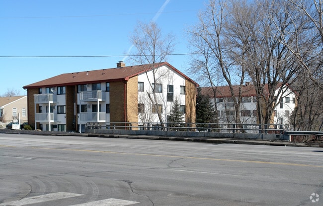
Property Record
427 Blake Rd N, Hopkins, MN 55343

NEARBY LISTINGS FOR SALE OR LEASE
Property Detail
427 Blake Rd N
Minneapolis-St. Paul-Bloomington, MN-WI
Auditors Subd. No. 239
19-117-21-11-0081
LOT 070 B AUDITORS SUBD. NO. 239 COM AT A PT IN W LINE OF LOT 70 DIS 240 FT S FROM NW COR THEREOF TH E AT RT ANGLES 335 6/10 FT TH S PAR TO E LINE OF SAID LOT 146 5/10 FT TH T IRREGULAR
Residentialacreage
Hennepin
AE
Minnesota
27053C0342F
70
0
1.03 AC
2024
Hopkins
023202
Minneapolis/St Paul
DEMOGRAPHICS near 427 Blake Rd N
1 Mile
3 Mile
5 Mile
2024 Total Population
13,371
101,701
247,375
2029 Population
13,135
100,237
243,903
Pop Growth 2024-2029
(1.77%)
(1.44%)
(1.40%)
Average Age
39
41
41
2024 Total Households
5,946
46,466
112,383
HH Growth 2024-2029
(1.85%)
(1.50%)
(1.41%)
Median Household Inc
$71,292
$89,143
$98,815
Avg Household Size
2.10
2.10
2.10
2024 Avg HH Vehicles
1.00
2.00
2.00
Median Home Value
$327,459
$381,930
$437,425
Median Year Built
1967
1969
1966
Nearby Places
Map Layers
Map Styles
 Street
 Aerial
- Restaurants
- Banks
- Shops
- Fitness
- Groceries
PUBLIC TRANSPORTATION
COMMUTER RAIL
Target Field Station (Northstar Corridor - Northstar Commuter Rail)
DRIVE
WALK
Distance
Target Field Station (Northstar Corridor - Northstar Commuter Rail)
13 min
8.2 mi
AIRPORT
Minneapolis-St Paul International/Wold-Chamberlain
DRIVE
WALK
Distance
Minneapolis-St Paul International/Wold-Chamberlain
23 min
16.0 mi
Freight Ports
Port Milwaukee
DRIVE
WALK
Distance
Port Milwaukee
386 min
346.7 mi
Nearby Properties
Address
Land Use
TOTAL SIZE
Lot Size
Zoning
Address
Land Use
TOTAL SIZE
Lot Size
Zoning
7.68 AC
Address
Land Use
TOTAL SIZE
Lot Size
Zoning
6.83 AC
Address
Land Use
TOTAL SIZE
Lot Size
Zoning
19,726 SF
2.08 AC
PCD1
Address
Land Use
TOTAL SIZE
Lot Size
Zoning
0.90 AC
Address
Land Use
TOTAL SIZE
Lot Size
Zoning
Address
Land Use
TOTAL SIZE
Lot Size
Zoning
3.07 AC
Address
Land Use
TOTAL SIZE
Lot Size
Zoning
4,497,396 SF
11.05 AC
Address
Land Use
TOTAL SIZE
Lot Size
Zoning
4.84 AC
Address
Land Use
TOTAL SIZE
Lot Size
Zoning
4.55 AC
Address
Land Use
TOTAL SIZE
Lot Size
Zoning
390,060 SF
3.11 AC
Address
Land Use
TOTAL SIZE
Lot Size
Zoning
406,842 SF
1.59 AC
Address
Land Use
TOTAL SIZE
Lot Size
Zoning
1.74 AC
Address
Land Use
TOTAL SIZE
Lot Size
Zoning
19.75 AC
Address
Land Use
TOTAL SIZE
Lot Size
Zoning
233,320 SF
17.37 AC
PUD
Address
Land Use
TOTAL SIZE
Lot Size
Zoning
224,581 SF
13.72 AC
PUD
Address
Land Use
TOTAL SIZE
Lot Size
Zoning
398,595 SF
1.91 AC
Address
Land Use
TOTAL SIZE
Lot Size
Zoning
288,096 SF
10.19 AC
Address
Land Use
TOTAL SIZE
Lot Size
Zoning
524,556 SF
4.56 AC
Address
Land Use
TOTAL SIZE
Lot Size
Zoning
38.20 AC
Address
Land Use
TOTAL SIZE
Lot Size
Zoning
379,488 SF
2.68 AC
Address
Land Use
TOTAL SIZE
Lot Size
Zoning
340,330 SF
2.22 AC
Address
Land Use
TOTAL SIZE
Lot Size
Zoning
Address
Land Use
TOTAL SIZE
Lot Size
Zoning
127,084 SF
17.21 AC
Address
Land Use
TOTAL SIZE
Lot Size
Zoning
244,941 SF
5.24 AC
Address
Land Use
TOTAL SIZE
Lot Size
Zoning
13.80 AC
Address
Land Use
TOTAL SIZE
Lot Size
Zoning
424,327 SF
2.16 AC
Address
Land Use
TOTAL SIZE
Lot Size
Zoning
2,018,298 SF
7.35 AC
Address
Land Use
TOTAL SIZE
Lot Size
Zoning
73,905 SF
11.66 AC
B3
Address
Land Use
TOTAL SIZE
Lot Size
Zoning
1.55 AC
Address
Land Use
TOTAL SIZE
Lot Size
Zoning
2.28 AC
The World's #1 Commercial Real Estate Marketplace
Connect with us
© 2025 CoStar Group
The information above has been obtained from sources believed reliable. While we do not doubt its accuracy we have not verified it and make no guarantee, warranty or representation about it. It is your responsibility to independently confirm its accuracy and completeness. Any projections, opinions, assumptions, or estimates used are for example only and do not represent the current or future performance of the property. The value of this transaction to you depends on tax and other factors which should be evaluated by your tax, financial, and legal advisors. You and your advisors should conduct a careful, independent investigation of the property to determine to your satisfaction the suitability of the property for your needs.