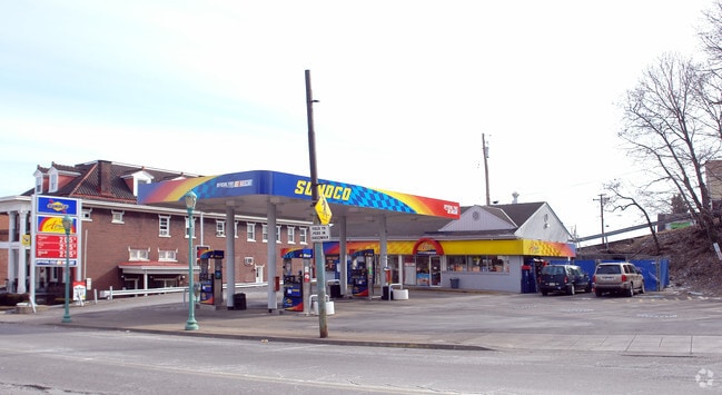
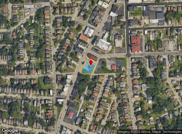
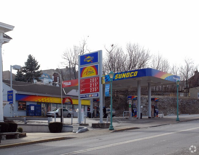
Property Record
427 Brownsville Rd, Pittsburgh, PA 15210
NEARBY LISTINGS FOR SALE OR LEASE
Property Detail
427 Brownsville Rd
Pittsburgh, PA
Mt Oliver Terrace Plan
0033-C-00195-0000-00
MT OLIVER TERRACE PLAN 5-6-7-8 PTS 4 & 9 LOT 16 1.05XAVG111.33X113.19 IN ALL BROWNSVILLE RD 1 STY BRK C B BLDG ( A PLUS MINI MART)
Servicestationmarket
Allegheny
X
Pennsylvania
42003C0361H
195
2024
0.35 AC
2025
South Pittsburgh/Rte 51
481000
Pittsburgh
DEMOGRAPHICS near 427 Brownsville Rd
1 Mile
3 Mile
5 Mile
2024 Total Population
20,099
148,133
390,434
2029 Population
20,061
146,313
384,570
Pop Growth 2024-2029
(0.19%)
(1.23%)
(1.50%)
Average Age
39
39
40
2024 Total Households
8,687
68,201
177,868
HH Growth 2024-2029
(0.22%)
(1.23%)
(1.56%)
Median Household Inc
$40,238
$55,643
$63,277
Avg Household Size
2.20
2.00
2.00
2024 Avg HH Vehicles
1.00
1.00
1.00
Median Home Value
$75,280
$149,716
$185,058
Median Year Built
1947
1950
1951
Nearby Places
Map Layers
Map Styles
 Street
 Aerial
- Restaurants
- Banks
- Shops
- Fitness
- Groceries
PUBLIC TRANSPORTATION
TRANSIT/SUBWAY
Bon Air (47L Library - Port Authority of Allegheny County Light Rail (The "T"), 47S South Hills Village - Port Authority of Allegheny County Light Rail (The "T"))
DRIVE
WALK
Distance
Bon Air (47L Library - Port Authority of Allegheny County Light Rail (The "T"), 47S South Hills Village - Port Authority of Allegheny County Light Rail (The "T"))
4 min
20 min
1.0 mi
COMMUTER RAIL
DRIVE
WALK
Distance
7 min
3.0 mi
AIRPORT
Pittsburgh International
DRIVE
WALK
Distance
Pittsburgh International
31 min
19.4 mi
Arnold Palmer Regional
DRIVE
WALK
Distance
Arnold Palmer Regional
70 min
43.5 mi
Nearby Properties
Address
Land Use
TOTAL SIZE
Lot Size
Zoning
Address
Land Use
TOTAL SIZE
Lot Size
Zoning
10.41 AC
Address
Land Use
TOTAL SIZE
Lot Size
Zoning
Address
Land Use
TOTAL SIZE
Lot Size
Zoning
14.70 AC
Address
Land Use
TOTAL SIZE
Lot Size
Zoning
Address
Land Use
TOTAL SIZE
Lot Size
Zoning
3.86 AC
Address
Land Use
TOTAL SIZE
Lot Size
Zoning
13.75 AC
Address
Land Use
TOTAL SIZE
Lot Size
Zoning
10.14 AC
Address
Land Use
TOTAL SIZE
Lot Size
Zoning
13.53 AC
Address
Land Use
TOTAL SIZE
Lot Size
Zoning
3.35 AC
Address
Land Use
TOTAL SIZE
Lot Size
Zoning
5.11 AC
Address
Land Use
TOTAL SIZE
Lot Size
Zoning
13.85 AC
Address
Land Use
TOTAL SIZE
Lot Size
Zoning
3.91 AC
Address
Land Use
TOTAL SIZE
Lot Size
Zoning
2.68 AC
Address
Land Use
TOTAL SIZE
Lot Size
Zoning
4.05 AC
Address
Land Use
TOTAL SIZE
Lot Size
Zoning
12.80 AC
Address
Land Use
TOTAL SIZE
Lot Size
Zoning
0.92 AC
Address
Land Use
TOTAL SIZE
Lot Size
Zoning
3.78 AC
Address
Land Use
TOTAL SIZE
Lot Size
Zoning
2.46 AC
Address
Land Use
TOTAL SIZE
Lot Size
Zoning
2.52 AC
Address
Land Use
TOTAL SIZE
Lot Size
Zoning
1.20 AC
Address
Land Use
TOTAL SIZE
Lot Size
Zoning
0.85 AC
Address
Land Use
TOTAL SIZE
Lot Size
Zoning
2.31 AC
Address
Land Use
TOTAL SIZE
Lot Size
Zoning
1.43 AC
Address
Land Use
TOTAL SIZE
Lot Size
Zoning
Address
Land Use
TOTAL SIZE
Lot Size
Zoning
Address
Land Use
TOTAL SIZE
Lot Size
Zoning
Address
Land Use
TOTAL SIZE
Lot Size
Zoning
0.19 AC
Address
Land Use
TOTAL SIZE
Lot Size
Zoning
Address
Land Use
TOTAL SIZE
Lot Size
Zoning
1.82 AC
Address
Land Use
TOTAL SIZE
Lot Size
Zoning
6.55 AC
The World's #1 Commercial Real Estate Marketplace
Connect with us
© 2025 CoStar Group
The information above has been obtained from sources believed reliable. While we do not doubt its accuracy we have not verified it and make no guarantee, warranty or representation about it. It is your responsibility to independently confirm its accuracy and completeness. Any projections, opinions, assumptions, or estimates used are for example only and do not represent the current or future performance of the property. The value of this transaction to you depends on tax and other factors which should be evaluated by your tax, financial, and legal advisors. You and your advisors should conduct a careful, independent investigation of the property to determine to your satisfaction the suitability of the property for your needs.