Property Record
427 Cedar Point Blvd, Cedar Point, NC 28584

Save to a Folder
{{folder.Name}}
{{folder.ListingIds.length}} Properties
{{folder.ListingIds.length}} Property
Create a New Folder
This Property Is For Sale
Property Detail
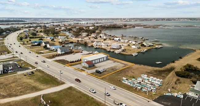
427 Cedar Point Blvd
Morehead City, NC
PART L31 32 CEDAR POINT
5374.13.13.7120000
CARTERET
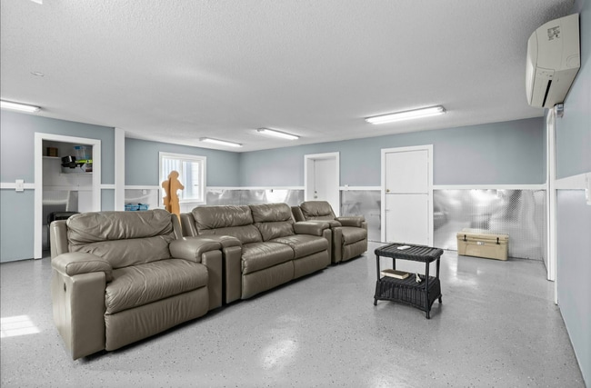
Warehouse
North Carolina
AE The base floodplain where base flood elevations are provided. AE Zones are now used on new format FIRMs instead of A1-A30 Zones.
31-32
2025
0.75 AC
2025
Coastal Carolina
970806
Other Market Areas
5,960 SF
NEARBY LISTINGS FOR SALE OR LEASE
-
-
View all Cedar Point listings for sale on LoopNet.com
DEMOGRAPHICS near 427 Cedar Point Blvd
1 mile
3 mile
5 mile
2025 Total Population
851
10,242
22,049
2030 Population
903
10,937
23,436
Pop Growth 2025-2030
+ 6.11%
+ 6.79%
+ 6.29%
Average Age
45
46
45
2025 Total Households
357
4,467
9,441
HH Growth 2025-2030
+ 6.16%
+ 6.90%
+ 6.51%
Median Household Inc
$81,666
$87,234
$87,480
Avg Household Size
2.40
2.30
2.30
2025 Avg HH Vehicles
2.00
2.00
2.00
Median Home Value
$402,206
$417,005
$380,816
Median Year Built
2002
1995
1996
Nearby Places
Map Layers
Map Styles
 Street
 Aerial
Layers
 Traffic
 Biking
Places
Listings with unknown addresses are not visible on the map
- Restaurants
- Banks
- Shops
- Fitness
- Groceries
PUBLIC TRANSPORTATION
AIRPORT
Albert J Ellis
Drive
Walk
Distance
Albert J Ellis
59 min
34.8 mi
Coastal Carolina Regional
Drive
Walk
Distance
Coastal Carolina Regional
61 min
37.7 mi
Freight Ports
Port of Morehead City
Drive
Walk
Distance
Port of Morehead City
37 min
23.4 mi
Nearby Properties
Address
Land Use
TOTAL SIZE
Lot Size
Zoning
Address
Land Use
TOTAL SIZE
Lot Size
Zoning
5,952 SF
18.03 AC
Address
Land Use
TOTAL SIZE
Lot Size
Zoning
184,862 SF
11.40 AC
Address
Land Use
TOTAL SIZE
Lot Size
Zoning
10,071 SF
9.13 AC
Address
Land Use
TOTAL SIZE
Lot Size
Zoning
82,345 SF
21.69 AC
Address
Land Use
TOTAL SIZE
Lot Size
Zoning
26,264 SF
20 AC
B-1
Address
Land Use
TOTAL SIZE
Lot Size
Zoning
60,867 SF
11.83 AC
Address
Land Use
TOTAL SIZE
Lot Size
Zoning
3,600 SF
30.42 AC
Address
Land Use
TOTAL SIZE
Lot Size
Zoning
6,000 SF
6.80 AC
Address
Land Use
TOTAL SIZE
Lot Size
Zoning
Address
Land Use
TOTAL SIZE
Lot Size
Zoning
44,906 SF
4.27 AC
Address
Land Use
TOTAL SIZE
Lot Size
Zoning
41,517 SF
30.20 AC
Address
Land Use
TOTAL SIZE
Lot Size
Zoning
16,048 SF
1.62 AC
Address
Land Use
TOTAL SIZE
Lot Size
Zoning
35,101 SF
3.33 AC
Address
Land Use
TOTAL SIZE
Lot Size
Zoning
10,377 SF
3.83 AC
B-2
Address
Land Use
TOTAL SIZE
Lot Size
Zoning
Address
Land Use
TOTAL SIZE
Lot Size
Zoning
27,666 SF
1.37 AC
Address
Land Use
TOTAL SIZE
Lot Size
Zoning
Address
Land Use
TOTAL SIZE
Lot Size
Zoning
37,992 SF
4.06 AC
Address
Land Use
TOTAL SIZE
Lot Size
Zoning
39,015 SF
4.45 AC
Address
Land Use
TOTAL SIZE
Lot Size
Zoning
110,331 SF
4.14 AC
Address
Land Use
TOTAL SIZE
Lot Size
Zoning
30,908 SF
1.03 AC
Address
Land Use
TOTAL SIZE
Lot Size
Zoning
37,651 SF
21.92 AC
PUD
Address
Land Use
TOTAL SIZE
Lot Size
Zoning
7,400 SF
3.98 AC
B-2
Address
Land Use
TOTAL SIZE
Lot Size
Zoning
34,412 SF
3.88 AC
Address
Land Use
TOTAL SIZE
Lot Size
Zoning
36,989 SF
6.81 AC
Address
Land Use
TOTAL SIZE
Lot Size
Zoning
63,781 SF
3.09 AC
B-1
Address
Land Use
TOTAL SIZE
Lot Size
Zoning
7,642 SF
3.16 AC
Address
Land Use
TOTAL SIZE
Lot Size
Zoning
24,800 SF
2.79 AC
G/E
Address
Land Use
TOTAL SIZE
Lot Size
Zoning
19,216 SF
6.36 AC
Address
Land Use
TOTAL SIZE
Lot Size
Zoning
4,040 SF
25.69 AC
The World's #1 Commercial Real Estate Marketplace
Connect with us
© 2026 CoStar Group
The information above has been obtained from sources believed reliable. While we do not doubt its accuracy we have not verified it and make no guarantee, warranty or representation about it. It is your responsibility to independently confirm its accuracy and completeness. Any projections, opinions, assumptions, or estimates used are for example only and do not represent the current or future performance of the property. The value of this transaction to you depends on tax and other factors which should be evaluated by your tax, financial, and legal advisors. You and your advisors should conduct a careful, independent investigation of the property to determine to your satisfaction the suitability of the property for your needs.