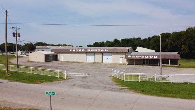
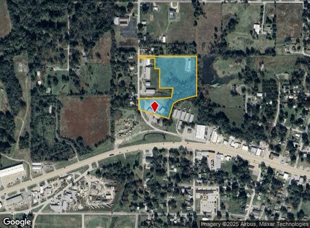
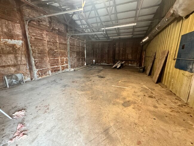
Property Record
427 N Maple St, Pryor, OK 74361
Current Lease Availabilities
NEARBY LISTINGS FOR SALE OR LEASE
Property Detail
427 N Maple St
1599-07-21N-19E-3-011-00
Pryor Acreage
Multifamilydwelling
PRYOR ACREAGE SEC 7-21-19 BEG NW COR SW 10.67A OF LOT 3 S 681.04' E 44' TO NW COR MCLAIN ADDN SE ALONG ADD TO PT 25' E OF NW
AE
Mayes
40097C0237E
Oklahoma
2025
19e
2025
7.36 AC
040100
Oklahoma East Area
4,056 SF
Other Market Areas
DEMOGRAPHICS near 427 N Maple St
1 Mile
3 Mile
5 Mile
2024 Total Population
2,571
11,590
14,404
2029 Population
2,825
12,472
15,516
Pop Growth 2024-2029
+ 9.88%
+ 7.61%
+ 7.72%
Average Age
38
38
39
2024 Total Households
993
4,525
5,570
HH Growth 2024-2029
+ 9.97%
+ 7.69%
+ 7.81%
Median Household Inc
$35,847
$45,172
$51,033
Avg Household Size
2.50
2.50
2.50
2024 Avg HH Vehicles
2.00
2.00
2.00
Median Home Value
$131,730
$167,481
$184,574
Median Year Built
1965
1974
1977
Nearby Places
- Restaurants
- Banks
- Shops
- Fitness
- Groceries
PUBLIC TRANSPORTATION
AIRPORT
Tulsa International
DRIVE
WALK
Distance
Tulsa International
47 min
36.5 mi
Freight Ports
DRIVE
WALK
Distance
36 min
26.1 mi
Nearby Properties
Address
Land Use
TOTAL SIZE
Lot Size
Zoning
Address
Land Use
TOTAL SIZE
Lot Size
Zoning
4,926 SF
10 AC
Address
Land Use
TOTAL SIZE
Lot Size
Zoning
11,790 SF
9 AC
Address
Land Use
TOTAL SIZE
Lot Size
Zoning
24,470 SF
2.09 AC
Address
Land Use
TOTAL SIZE
Lot Size
Zoning
8,242 SF
8.28 AC
Address
Land Use
TOTAL SIZE
Lot Size
Zoning
8,550 SF
0.34 AC
Address
Land Use
TOTAL SIZE
Lot Size
Zoning
89,982 SF
7.43 AC
Address
Land Use
TOTAL SIZE
Lot Size
Zoning
11,232 SF
0.40 AC
Address
Land Use
TOTAL SIZE
Lot Size
Zoning
8,400 SF
0.45 AC
Address
Land Use
TOTAL SIZE
Lot Size
Zoning
3,910 SF
3.89 AC
Address
Land Use
TOTAL SIZE
Lot Size
Zoning
5,562 SF
0.44 AC
Address
Land Use
TOTAL SIZE
Lot Size
Zoning
10,442 SF
0.34 AC
Address
Land Use
TOTAL SIZE
Lot Size
Zoning
7,800 SF
0.98 AC
Address
Land Use
TOTAL SIZE
Lot Size
Zoning
3,264 SF
2.86 AC
Address
Land Use
TOTAL SIZE
Lot Size
Zoning
1,060 SF
7.42 AC
Address
Land Use
TOTAL SIZE
Lot Size
Zoning
5,000 SF
0.68 AC
Address
Land Use
TOTAL SIZE
Lot Size
Zoning
81,116 SF
6.53 AC
Address
Land Use
TOTAL SIZE
Lot Size
Zoning
11,704 SF
0.34 AC
Address
Land Use
TOTAL SIZE
Lot Size
Zoning
2,880 SF
5.84 AC
Address
Land Use
TOTAL SIZE
Lot Size
Zoning
2,194 SF
0.77 AC
Address
Land Use
TOTAL SIZE
Lot Size
Zoning
4,500 SF
0.60 AC
Address
Land Use
TOTAL SIZE
Lot Size
Zoning
14,636 SF
2.09 AC
Address
Land Use
TOTAL SIZE
Lot Size
Zoning
0.37 AC
Address
Land Use
TOTAL SIZE
Lot Size
Zoning
1,200 SF
23 AC
Address
Land Use
TOTAL SIZE
Lot Size
Zoning
10,092 SF
0.82 AC
Address
Land Use
TOTAL SIZE
Lot Size
Zoning
9,516 SF
1.18 AC
Address
Land Use
TOTAL SIZE
Lot Size
Zoning
5,400 SF
0.17 AC
The World's #1 Commercial Real Estate Marketplace
Connect with us
© 2025 CoStar Group
The information above has been obtained from sources believed reliable. While we do not doubt its accuracy we have not verified it and make no guarantee, warranty or representation about it. It is your responsibility to independently confirm its accuracy and completeness. Any projections, opinions, assumptions, or estimates used are for example only and do not represent the current or future performance of the property. The value of this transaction to you depends on tax and other factors which should be evaluated by your tax, financial, and legal advisors. You and your advisors should conduct a careful, independent investigation of the property to determine to your satisfaction the suitability of the property for your needs.