Property Record
4270 Webster Ave, Cincinnati, OH 45236
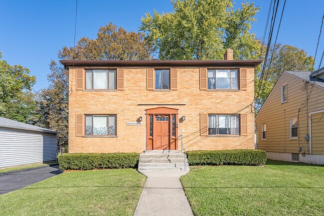

Property Detail
4270 Webster Ave
Cincinnati, OH-KY-IN
4270 WEBSTER 51 X 130 LOTS 162& 163 & PT LOT 161 ADDN SUB PARS 196-197-290 CONS
609-0012-0196
Hamilton
Apartment
Ohio
B and X Area of moderate flood hazard, usually the area between the limits of the 100-year and 500-year floods.
162&
2025
0.15 AC
2025
Deer Park
023702
Cincinnati/Dayton
3,150 SF
NEARBY LISTINGS FOR SALE OR LEASE
DEMOGRAPHICS near 4270 Webster Ave
1 mile
3 mile
5 mile
2025 Total Population
13,982
80,074
192,262
2030 Population
14,113
80,805
193,669
Pop Growth 2025-2030
+ 0.94%
+ 0.91%
+ 0.73%
Average Age
42
41
40
2025 Total Households
6,586
34,459
84,608
HH Growth 2025-2030
+ 0.93%
+ 0.91%
+ 0.72%
Median Household Inc
$72,516
$86,418
$76,952
Avg Household Size
2.00
2.20
2.20
2025 Avg HH Vehicles
2.00
2.00
2.00
Median Home Value
$219,744
$290,755
$300,059
Median Year Built
1951
1957
1954
Nearby Places
Map Layers
Map Styles
 Street
 Aerial
Layers
 Traffic
 Biking
Places
Listings with unknown addresses are not visible on the map
- Restaurants
- Banks
- Shops
- Fitness
- Groceries
PUBLIC TRANSPORTATION
AIRPORT
Cincinnati/Northern Kentucky International
Drive
Walk
Distance
Cincinnati/Northern Kentucky International
44 min
25.4 mi
SALE & LEASE HISTORY
LISTING DATE
SALE/LEASE

Nov 10, 2021
For Sale
Nearby Properties
Address
Land Use
TOTAL SIZE
Lot Size
Zoning
Address
Land Use
TOTAL SIZE
Lot Size
Zoning
31.26 AC
E
Address
Land Use
TOTAL SIZE
Lot Size
Zoning
8.11 AC
E
Address
Land Use
TOTAL SIZE
Lot Size
Zoning
317,592 SF
29.46 AC
E
Address
Land Use
TOTAL SIZE
Lot Size
Zoning
12.43 AC
OO
Address
Land Use
TOTAL SIZE
Lot Size
Zoning
Address
Land Use
TOTAL SIZE
Lot Size
Zoning
Address
Land Use
TOTAL SIZE
Lot Size
Zoning
49.51 AC
Address
Land Use
TOTAL SIZE
Lot Size
Zoning
9.16 AC
Address
Land Use
TOTAL SIZE
Lot Size
Zoning
119.08 AC
R1
Address
Land Use
TOTAL SIZE
Lot Size
Zoning
Address
Land Use
TOTAL SIZE
Lot Size
Zoning
15.91 AC
E
Address
Land Use
TOTAL SIZE
Lot Size
Zoning
5.78 AC
Address
Land Use
TOTAL SIZE
Lot Size
Zoning
5.07 AC
Address
Land Use
TOTAL SIZE
Lot Size
Zoning
1,238 SF
14.03 AC
Address
Land Use
TOTAL SIZE
Lot Size
Zoning
Address
Land Use
TOTAL SIZE
Lot Size
Zoning
0.26 AC
RM12
Address
Land Use
TOTAL SIZE
Lot Size
Zoning
35.74 AC
Address
Land Use
TOTAL SIZE
Lot Size
Zoning
6.91 AC
Address
Land Use
TOTAL SIZE
Lot Size
Zoning
4.57 AC
Address
Land Use
TOTAL SIZE
Lot Size
Zoning
7.06 AC
Address
Land Use
TOTAL SIZE
Lot Size
Zoning
6.80 AC
Address
Land Use
TOTAL SIZE
Lot Size
Zoning
1,152 SF
24.78 AC
B
Address
Land Use
TOTAL SIZE
Lot Size
Zoning
5.79 AC
Address
Land Use
TOTAL SIZE
Lot Size
Zoning
1,187 SF
31.75 AC
ML
Address
Land Use
TOTAL SIZE
Lot Size
Zoning
2.08 AC
Address
Land Use
TOTAL SIZE
Lot Size
Zoning
19.17 AC
ML
Address
Land Use
TOTAL SIZE
Lot Size
Zoning
17,055 SF
6.51 AC
D1
Address
Land Use
TOTAL SIZE
Lot Size
Zoning
23.45 AC
Address
Land Use
TOTAL SIZE
Lot Size
Zoning
0.77 AC
EE
Address
Land Use
TOTAL SIZE
Lot Size
Zoning
The World's #1 Commercial Real Estate Marketplace
Connect with us
© 2026 CoStar Group
The information above has been obtained from sources believed reliable. While we do not doubt its accuracy we have not verified it and make no guarantee, warranty or representation about it. It is your responsibility to independently confirm its accuracy and completeness. Any projections, opinions, assumptions, or estimates used are for example only and do not represent the current or future performance of the property. The value of this transaction to you depends on tax and other factors which should be evaluated by your tax, financial, and legal advisors. You and your advisors should conduct a careful, independent investigation of the property to determine to your satisfaction the suitability of the property for your needs.