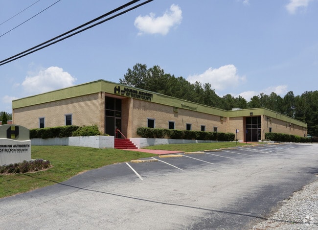
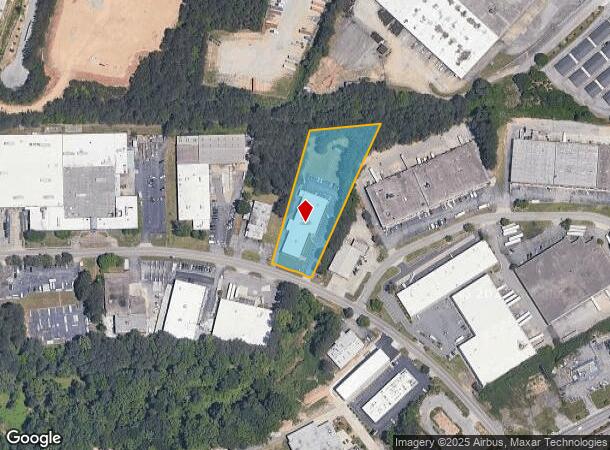
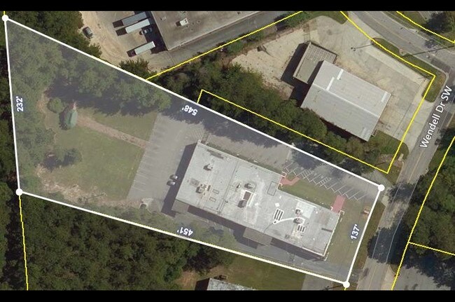
Property Record
4275 Wendell Dr Sw, Atlanta, GA 30336

NEARBY LISTINGS FOR SALE OR LEASE
Property Detail
4275 Wendell Dr Sw
14F-0052-LL-049-0
Fulton
Governmentalpublicusegeneral
Georgia
X
52
13121C0219F
2.02 AC
2023
Fulton District
2025
Atlanta
010312
Atlanta-Sandy Springs-Roswell, GA
15,908 SF
DEMOGRAPHICS near 4275 Wendell Dr Sw
1 Mile
3 Mile
5 Mile
2024 Total Population
2,393
54,551
146,695
2029 Population
2,473
56,603
152,042
Pop Growth 2024-2029
+ 3.34%
+ 3.76%
+ 3.64%
Average Age
41
37
38
2024 Total Households
991
21,229
57,641
HH Growth 2024-2029
+ 3.03%
+ 3.82%
+ 3.71%
Median Household Inc
$52,635
$51,908
$60,409
Avg Household Size
2.30
2.50
2.50
2024 Avg HH Vehicles
1.00
1.00
2.00
Median Home Value
$117,500
$238,881
$278,303
Median Year Built
1980
1982
1983
Nearby Places
Map Layers
Map Styles
 Street
 Aerial
- Restaurants
- Banks
- Shops
- Fitness
- Groceries
PUBLIC TRANSPORTATION
AIRPORT
Hartsfield - Jackson Atlanta International
DRIVE
WALK
Distance
Hartsfield - Jackson Atlanta International
27 min
17.3 mi
SALE & LEASE HISTORY
LISTING DATE
SALE/LEASE

Jul 22, 2019
For Lease
Nearby Properties
Address
Land Use
TOTAL SIZE
Lot Size
Zoning
Address
Land Use
TOTAL SIZE
Lot Size
Zoning
Address
Land Use
TOTAL SIZE
Lot Size
Zoning
3.25 AC
MU
Address
Land Use
TOTAL SIZE
Lot Size
Zoning
1,151,446 SF
I2
Address
Land Use
TOTAL SIZE
Lot Size
Zoning
538,535 SF
32.40 AC
I2
Address
Land Use
TOTAL SIZE
Lot Size
Zoning
499,198 SF
9.49 AC
RG3
Address
Land Use
TOTAL SIZE
Lot Size
Zoning
415,834 SF
17.62 AC
I2
Address
Land Use
TOTAL SIZE
Lot Size
Zoning
6,603,740 SF
24.69 AC
RG3
Address
Land Use
TOTAL SIZE
Lot Size
Zoning
285.03 AC
I2
Address
Land Use
TOTAL SIZE
Lot Size
Zoning
290,784 SF
21.09 AC
RM-12
Address
Land Use
TOTAL SIZE
Lot Size
Zoning
694,436 SF
36.80 AC
HI
Address
Land Use
TOTAL SIZE
Lot Size
Zoning
283,396 SF
29.88 AC
RM-12
Address
Land Use
TOTAL SIZE
Lot Size
Zoning
814,536 SF
37 AC
R3
Address
Land Use
TOTAL SIZE
Lot Size
Zoning
523,551 SF
50.93 AC
LI
Address
Land Use
TOTAL SIZE
Lot Size
Zoning
1,825,146 SF
16.16 AC
RG3
Address
Land Use
TOTAL SIZE
Lot Size
Zoning
567,480 SF
44.13 AC
LI
Address
Land Use
TOTAL SIZE
Lot Size
Zoning
237,515 SF
16.68 AC
C2
Address
Land Use
TOTAL SIZE
Lot Size
Zoning
241,200 SF
18.40 AC
RM-12
Address
Land Use
TOTAL SIZE
Lot Size
Zoning
729,946 SF
34.07 AC
M2
Address
Land Use
TOTAL SIZE
Lot Size
Zoning
70.35 AC
R3
Address
Land Use
TOTAL SIZE
Lot Size
Zoning
498,167 SF
11.18 AC
HI/WS
Address
Land Use
TOTAL SIZE
Lot Size
Zoning
520,556 SF
5.47 AC
RG2
Address
Land Use
TOTAL SIZE
Lot Size
Zoning
77.56 AC
RG3
Address
Land Use
TOTAL SIZE
Lot Size
Zoning
77.30 AC
M2
Address
Land Use
TOTAL SIZE
Lot Size
Zoning
152,348 SF
12.76 AC
RM-12
Address
Land Use
TOTAL SIZE
Lot Size
Zoning
350,840 SF
22.90 AC
LI
Address
Land Use
TOTAL SIZE
Lot Size
Zoning
353,269 SF
32.80 AC
LI
Address
Land Use
TOTAL SIZE
Lot Size
Zoning
420,810 SF
23.48 AC
I1
Address
Land Use
TOTAL SIZE
Lot Size
Zoning
339,382 SF
18.45 AC
HI
Address
Land Use
TOTAL SIZE
Lot Size
Zoning
286,400 SF
17.29 AC
I2
Address
Land Use
TOTAL SIZE
Lot Size
Zoning
1,715,322 SF
18.09 AC
A1
The World's #1 Commercial Real Estate Marketplace
Connect with us
© 2025 CoStar Group
The information above has been obtained from sources believed reliable. While we do not doubt its accuracy we have not verified it and make no guarantee, warranty or representation about it. It is your responsibility to independently confirm its accuracy and completeness. Any projections, opinions, assumptions, or estimates used are for example only and do not represent the current or future performance of the property. The value of this transaction to you depends on tax and other factors which should be evaluated by your tax, financial, and legal advisors. You and your advisors should conduct a careful, independent investigation of the property to determine to your satisfaction the suitability of the property for your needs.