Property Record
4934 Paddock Rd, Cincinnati, OH 45237
NEARBY LISTINGS FOR SALE OR LEASE
Property Detail
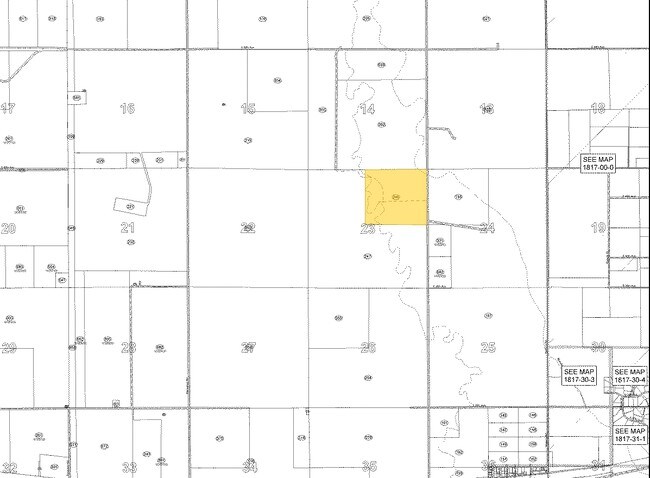
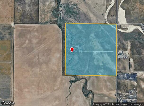
4934 Paddock Rd
1819-00-0-00-246
Agriculture Prop
Farms
SECT,TWN,RNG:23-3-65 DESC: PARC OF LAND IN THE NE4 OF SEC 23 DESC AS FOLS BEG AT THE NE COR OF SD SEC 23 TH N 88D 41M 35S W 30 FT TO A PT ON WLY ROW LN OF HUDSON RD SD PT BEING THE POB TH S 00D 15M 03S W 2642/37 FT TH N 88D 47M 39S W 2619/69 FT TH N
AE
Adams
08001C0669J
Colorado
2024
158.82 AC
2024
Northeast Denver
007103
Denver
1,613 SF
Denver-Aurora-Lakewood, CO
DEMOGRAPHICS near 4934 Paddock Rd
1 Mile
3 Mile
5 Mile
2024 Total Population
1
211
4,882
2029 Population
1
217
5,275
Pop Growth 2024-2029
0.00%
+ 2.84%
+ 8.05%
Average Age
0
41
34
2024 Total Households
0
71
1,457
HH Growth 2024-2029
0.00%
+ 2.82%
+ 7.76%
Median Household Inc
$0
$82,500
$81,785
Avg Household Size
.00
2.90
3.20
2024 Avg HH Vehicles
.00
3.00
2.00
Median Home Value
$0
$637,500
$491,059
Median Year Built
0
1990
2010
Nearby Places
- Restaurants
- Banks
- Shops
- Fitness
- Groceries
PUBLIC TRANSPORTATION
COMMUTER RAIL
Denver Airport Station (Union Station to Denver Airport Station - Regional Transportation District)
DRIVE
WALK
Distance
Denver Airport Station (Union Station to Denver Airport Station - Regional Transportation District)
19 min
9.8 mi
AIRPORT
Denver International
DRIVE
WALK
Distance
Denver International
19 min
10.3 mi
Freight Ports
Tulsa Port Of Catoosa
DRIVE
WALK
Distance
Tulsa Port Of Catoosa
710 min
690.8 mi
Nearby Properties
Address
Land Use
TOTAL SIZE
Lot Size
Zoning
Address
Land Use
TOTAL SIZE
Lot Size
Zoning
Address
Land Use
TOTAL SIZE
Lot Size
Zoning
Address
Land Use
TOTAL SIZE
Lot Size
Zoning
166.32 AC
Address
Land Use
TOTAL SIZE
Lot Size
Zoning
Address
Land Use
TOTAL SIZE
Lot Size
Zoning
Address
Land Use
TOTAL SIZE
Lot Size
Zoning
291.65 AC
Address
Land Use
TOTAL SIZE
Lot Size
Zoning
1,320 SF
70.73 AC
Address
Land Use
TOTAL SIZE
Lot Size
Zoning
57.83 AC
Address
Land Use
TOTAL SIZE
Lot Size
Zoning
16,800 SF
27.57 AC
I1
Address
Land Use
TOTAL SIZE
Lot Size
Zoning
22,304 SF
20.59 AC
Address
Land Use
TOTAL SIZE
Lot Size
Zoning
10,000 SF
28.18 AC
PUD
Address
Land Use
TOTAL SIZE
Lot Size
Zoning
15,625 SF
1.59 AC
C4
Address
Land Use
TOTAL SIZE
Lot Size
Zoning
10,757 SF
3.21 AC
Address
Land Use
TOTAL SIZE
Lot Size
Zoning
649,044 SF
15.92 AC
PUD
Address
Land Use
TOTAL SIZE
Lot Size
Zoning
4.70 AC
Address
Land Use
TOTAL SIZE
Lot Size
Zoning
14,933 SF
0.39 AC
PUD
Address
Land Use
TOTAL SIZE
Lot Size
Zoning
12,200 SF
12.15 AC
Address
Land Use
TOTAL SIZE
Lot Size
Zoning
6,526 SF
1.03 AC
C2
Address
Land Use
TOTAL SIZE
Lot Size
Zoning
16,158 SF
0.16 AC
A3
Address
Land Use
TOTAL SIZE
Lot Size
Zoning
3,210 SF
335.44 AC
Address
Land Use
TOTAL SIZE
Lot Size
Zoning
3,744 SF
14.03 AC
C5
Address
Land Use
TOTAL SIZE
Lot Size
Zoning
5,090 SF
1.70 AC
Address
Land Use
TOTAL SIZE
Lot Size
Zoning
14,164 SF
41.76 AC
A3
Address
Land Use
TOTAL SIZE
Lot Size
Zoning
656.04 AC
A3
Address
Land Use
TOTAL SIZE
Lot Size
Zoning
640 AC
A3
Address
Land Use
TOTAL SIZE
Lot Size
Zoning
955.14 AC
PUD
Address
Land Use
TOTAL SIZE
Lot Size
Zoning
Address
Land Use
TOTAL SIZE
Lot Size
Zoning
619.91 AC
Address
Land Use
TOTAL SIZE
Lot Size
Zoning
3,488 SF
7.33 AC
AV
Address
Land Use
TOTAL SIZE
Lot Size
Zoning
503.09 AC
The World's #1 Commercial Real Estate Marketplace
Connect with us
© 2025 CoStar Group
The information above has been obtained from sources believed reliable. While we do not doubt its accuracy we have not verified it and make no guarantee, warranty or representation about it. It is your responsibility to independently confirm its accuracy and completeness. Any projections, opinions, assumptions, or estimates used are for example only and do not represent the current or future performance of the property. The value of this transaction to you depends on tax and other factors which should be evaluated by your tax, financial, and legal advisors. You and your advisors should conduct a careful, independent investigation of the property to determine to your satisfaction the suitability of the property for your needs.