Property Record
4279 S Us Highway 27, Clermont, FL 34711
Current Lease Availabilities
NEARBY LISTINGS FOR SALE OR LEASE
Property Detail
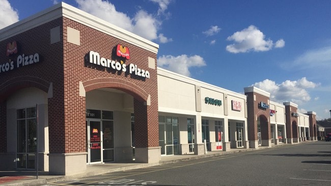
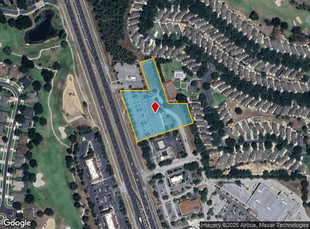
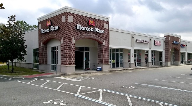
4279 S Us Highway 27
Orlando-Kissimmee-Sanford, FL
Whitehall At Kings Ridge
09-23-26-0002-000-02600
FROM SW COR OF TRACT A WHITEHALL AT KINGS RIDGE PHASE III RUN N 18-22-36 W 360.49 FT FOR POB RUN S 71-37-16 W 399.91 FT TO NELY R/W LINE OF US HWY 27 N 18-22-36 W ALONG R/W LINE 30.44 FT N 71-37-34 E 5 FT N 18-22-36 W 362 FT S 89-34-30 E 188 FT N 18-
Stripcommercialcenter
Lake
X
Florida
12095C0200H
26
0
2.93 AC
2026
Lake County
031308
Orlando
16,899 SF
DEMOGRAPHICS near 4279 S Us Highway 27
1 Mile
3 Mile
5 Mile
2024 Total Population
8,224
37,042
78,276
2029 Population
9,592
43,224
91,119
Pop Growth 2024-2029
+ 16.63%
+ 16.69%
+ 16.41%
Average Age
53
44
42
2024 Total Households
3,556
14,135
29,290
HH Growth 2024-2029
+ 16.28%
+ 16.46%
+ 16.25%
Median Household Inc
$67,715
$84,280
$83,692
Avg Household Size
2.30
2.60
2.60
2024 Avg HH Vehicles
2.00
2.00
2.00
Median Home Value
$279,623
$317,129
$323,899
Median Year Built
2004
2005
2003
Nearby Places
- Restaurants
- Banks
- Shops
- Fitness
- Groceries
PUBLIC TRANSPORTATION
AIRPORT
Orlando International
DRIVE
WALK
Distance
Orlando International
47 min
34.7 mi
Freight Ports
Port of Tampa Bay
DRIVE
WALK
Distance
Port of Tampa Bay
95 min
76.3 mi
Nearby Properties
Address
Land Use
TOTAL SIZE
Lot Size
Zoning
Address
Land Use
TOTAL SIZE
Lot Size
Zoning
285,581 SF
19.34 AC
CFD
Address
Land Use
TOTAL SIZE
Lot Size
Zoning
326,899 SF
20.77 AC
Address
Land Use
TOTAL SIZE
Lot Size
Zoning
303,624 SF
10.75 AC
Address
Land Use
TOTAL SIZE
Lot Size
Zoning
299,214 SF
25.01 AC
PUD
Address
Land Use
TOTAL SIZE
Lot Size
Zoning
321,012 SF
22.55 AC
PUD
Address
Land Use
TOTAL SIZE
Lot Size
Zoning
179,290 SF
23.79 AC
Address
Land Use
TOTAL SIZE
Lot Size
Zoning
192,907 SF
16.43 AC
PUD
Address
Land Use
TOTAL SIZE
Lot Size
Zoning
273,592 SF
91.55 AC
R6
Address
Land Use
TOTAL SIZE
Lot Size
Zoning
Address
Land Use
TOTAL SIZE
Lot Size
Zoning
52,986 SF
18.27 AC
Address
Land Use
TOTAL SIZE
Lot Size
Zoning
2,000 SF
30.62 AC
CFD
Address
Land Use
TOTAL SIZE
Lot Size
Zoning
106,799 SF
9.06 AC
MP
Address
Land Use
TOTAL SIZE
Lot Size
Zoning
124,634 SF
18.57 AC
Address
Land Use
TOTAL SIZE
Lot Size
Zoning
126,067 SF
9.34 AC
Address
Land Use
TOTAL SIZE
Lot Size
Zoning
200,439 SF
21.03 AC
C2
Address
Land Use
TOTAL SIZE
Lot Size
Zoning
153,522 SF
29.72 AC
PUD
Address
Land Use
TOTAL SIZE
Lot Size
Zoning
227,034 SF
29.20 AC
Address
Land Use
TOTAL SIZE
Lot Size
Zoning
79,771 SF
13.15 AC
PUD
Address
Land Use
TOTAL SIZE
Lot Size
Zoning
109,254 SF
5.54 AC
Address
Land Use
TOTAL SIZE
Lot Size
Zoning
123.98 AC
Address
Land Use
TOTAL SIZE
Lot Size
Zoning
102,086 SF
5.32 AC
Address
Land Use
TOTAL SIZE
Lot Size
Zoning
158,351 SF
19.10 AC
C2
Address
Land Use
TOTAL SIZE
Lot Size
Zoning
72,600 SF
5.73 AC
Address
Land Use
TOTAL SIZE
Lot Size
Zoning
61,515 SF
9.92 AC
R6
Address
Land Use
TOTAL SIZE
Lot Size
Zoning
99,348 SF
34.10 AC
R1A
Address
Land Use
TOTAL SIZE
Lot Size
Zoning
30,415 SF
3.47 AC
Address
Land Use
TOTAL SIZE
Lot Size
Zoning
46,996 SF
7.93 AC
CP
Address
Land Use
TOTAL SIZE
Lot Size
Zoning
128.65 AC
A
Address
Land Use
TOTAL SIZE
Lot Size
Zoning
108,772 SF
12 AC
Address
Land Use
TOTAL SIZE
Lot Size
Zoning
49,972 SF
10.25 AC
CFD
The World's #1 Commercial Real Estate Marketplace
Connect with us
© 2025 CoStar Group
The information above has been obtained from sources believed reliable. While we do not doubt its accuracy we have not verified it and make no guarantee, warranty or representation about it. It is your responsibility to independently confirm its accuracy and completeness. Any projections, opinions, assumptions, or estimates used are for example only and do not represent the current or future performance of the property. The value of this transaction to you depends on tax and other factors which should be evaluated by your tax, financial, and legal advisors. You and your advisors should conduct a careful, independent investigation of the property to determine to your satisfaction the suitability of the property for your needs.