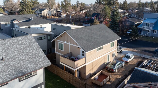
Property Record
428 Ne Burnside Ave, Bend, OR 97701


NEARBY LISTINGS FOR SALE OR LEASE
Property Detail
428 Ne Burnside Ave
Bend, OR
Keystone Terrace
273566
Deschutes
Sfr
Oregon
X
0.14 AC
41017C0670E
Larkspur
2,620 SF
Portland
DEMOGRAPHICS near 428 Ne Burnside Ave
1 Mile
3 Mile
5 Mile
2024 Total Population
7,781
87,180
113,862
2029 Population
8,472
96,154
125,572
Pop Growth 2024-2029
+ 8.88%
+ 10.29%
+ 10.28%
Average Age
39
41
41
2024 Total Households
3,531
36,331
46,530
HH Growth 2024-2029
+ 8.95%
+ 10.37%
+ 10.38%
Median Household Inc
$54,693
$80,645
$85,842
Avg Household Size
2.10
2.30
2.40
2024 Avg HH Vehicles
2.00
2.00
2.00
Median Home Value
$498,147
$595,932
$635,776
Median Year Built
1979
1999
2000
Nearby Places
Map Layers
Map Styles
 Street
 Aerial
- Restaurants
- Banks
- Shops
- Fitness
- Groceries
PUBLIC TRANSPORTATION
AIRPORT
Roberts Field
DRIVE
WALK
Distance
Roberts Field
26 min
17.1 mi
SALE & LEASE HISTORY
LISTING DATE
SALE/LEASE

Nov 04, 2024
For Sale
Nearby Properties
Address
Land Use
TOTAL SIZE
Lot Size
Zoning
Address
Land Use
TOTAL SIZE
Lot Size
Zoning
35.14 AC
RH
Address
Land Use
TOTAL SIZE
Lot Size
Zoning
61,869 SF
35.14 AC
RH
Address
Land Use
TOTAL SIZE
Lot Size
Zoning
35.14 AC
RH
Address
Land Use
TOTAL SIZE
Lot Size
Zoning
10,490 SF
35.14 AC
RH
Address
Land Use
TOTAL SIZE
Lot Size
Zoning
116,476 SF
35.14 AC
RH
Address
Land Use
TOTAL SIZE
Lot Size
Zoning
35.14 AC
RH
Address
Land Use
TOTAL SIZE
Lot Size
Zoning
35.14 AC
Address
Land Use
TOTAL SIZE
Lot Size
Zoning
144,000 SF
35.14 AC
RH
Address
Land Use
TOTAL SIZE
Lot Size
Zoning
35.14 AC
RH
Address
Land Use
TOTAL SIZE
Lot Size
Zoning
35.14 AC
RH
Address
Land Use
TOTAL SIZE
Lot Size
Zoning
11,947 SF
35.14 AC
RH
Address
Land Use
TOTAL SIZE
Lot Size
Zoning
35.14 AC
Address
Land Use
TOTAL SIZE
Lot Size
Zoning
35.14 AC
Address
Land Use
TOTAL SIZE
Lot Size
Zoning
35.14 AC
RH
Address
Land Use
TOTAL SIZE
Lot Size
Zoning
144,000 SF
35.14 AC
RH
Address
Land Use
TOTAL SIZE
Lot Size
Zoning
144,000 SF
35.14 AC
RH
Address
Land Use
TOTAL SIZE
Lot Size
Zoning
35.14 AC
RH
Address
Land Use
TOTAL SIZE
Lot Size
Zoning
12,000 SF
2.77 AC
IL
Address
Land Use
TOTAL SIZE
Lot Size
Zoning
2.77 AC
IL
Address
Land Use
TOTAL SIZE
Lot Size
Zoning
3.74 AC
MR
Address
Land Use
TOTAL SIZE
Lot Size
Zoning
25,574 SF
3.74 AC
MR
Address
Land Use
TOTAL SIZE
Lot Size
Zoning
27,863 SF
4.23 AC
MU
Address
Land Use
TOTAL SIZE
Lot Size
Zoning
318,598 SF
9.77 AC
RS
Address
Land Use
TOTAL SIZE
Lot Size
Zoning
201,150 SF
3.75 AC
RH
Address
Land Use
TOTAL SIZE
Lot Size
Zoning
166,371 SF
2.52 AC
MU
Address
Land Use
TOTAL SIZE
Lot Size
Zoning
199,892 SF
19.16 AC
CG
Address
Land Use
TOTAL SIZE
Lot Size
Zoning
1.04 AC
CB
Address
Land Use
TOTAL SIZE
Lot Size
Zoning
201,575 SF
1.04 AC
CB
Address
Land Use
TOTAL SIZE
Lot Size
Zoning
165,048 SF
4.68 AC
RM
Address
Land Use
TOTAL SIZE
Lot Size
Zoning
1,248 SF
5.04 AC
RM
The World's #1 Commercial Real Estate Marketplace
Connect with us
© 2026 CoStar Group
The information above has been obtained from sources believed reliable. While we do not doubt its accuracy we have not verified it and make no guarantee, warranty or representation about it. It is your responsibility to independently confirm its accuracy and completeness. Any projections, opinions, assumptions, or estimates used are for example only and do not represent the current or future performance of the property. The value of this transaction to you depends on tax and other factors which should be evaluated by your tax, financial, and legal advisors. You and your advisors should conduct a careful, independent investigation of the property to determine to your satisfaction the suitability of the property for your needs.