Property Record
428 Us Highway 90 W, Defuniak Springs, FL 32433
NEARBY LISTINGS FOR SALE OR LEASE
-
-
View all Defuniak Springs listings for sale on LoopNet.com
Property Detail
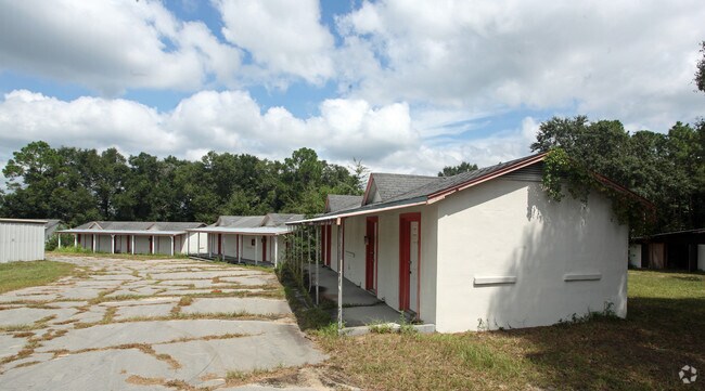
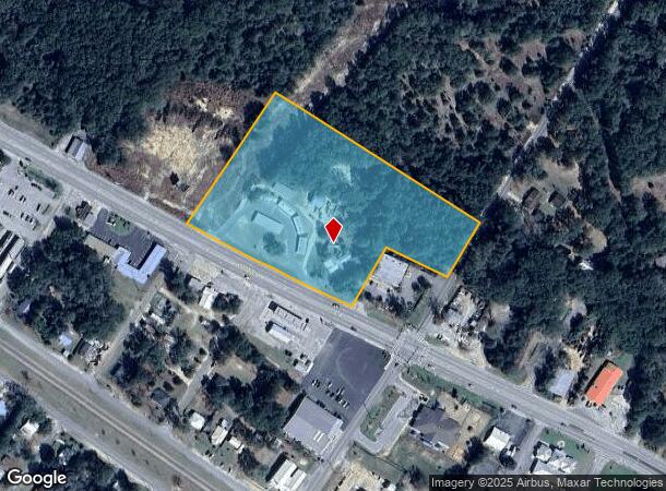
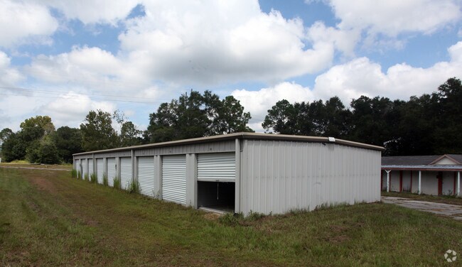
428 Us Highway 90 W
Crestview-Fort Walton Beach-Destin, FL
Defuniak Springs
25-3N-19-19070-001-8320
BEG AT THE NE/C OF BLK 1828 ACCORDING TO THE MAP OF DEFUNIAK SPRINGS AS DRAWN BY W.J. VAN KIRK THENCE PROCEED ALONG THE ELY LINE OF SAID BLK 1828 AND THE EXTENSION THEREOF S 34 DEG 0815W 397.69FT TO THE NLY ROW LINE OF US HWY 90 THENCE N 64 DEG 4743W
Warehouse
Walton
X
Florida
12131C0260G
8320
2025
6.62 AC
2025
Florida Panhandle Area
950304
Other Market Areas
11,630 SF
DEMOGRAPHICS near 428 Us Highway 90 W
1 Mile
3 Mile
5 Mile
2024 Total Population
1,701
8,545
12,243
2029 Population
2,027
10,236
14,690
Pop Growth 2024-2029
+ 19.17%
+ 19.79%
+ 19.99%
Average Age
37
38
39
2024 Total Households
648
2,777
3,980
HH Growth 2024-2029
+ 18.98%
+ 19.66%
+ 19.92%
Median Household Inc
$40,385
$40,388
$39,661
Avg Household Size
2.50
2.50
2.50
2024 Avg HH Vehicles
2.00
2.00
2.00
Median Home Value
$137,815
$97,373
$93,669
Median Year Built
1981
1987
1991
Nearby Places
Map Layers
Map Styles
 Street
 Aerial
- Restaurants
- Banks
- Shops
- Fitness
- Groceries
PUBLIC TRANSPORTATION
AIRPORT
Eglin AFB/Destin-Ft Walton Beach
DRIVE
WALK
Distance
Eglin AFB/Destin-Ft Walton Beach
67 min
37.0 mi
Freight Ports
Port of Panama City
DRIVE
WALK
Distance
Port of Panama City
79 min
57.8 mi
Nearby Properties
Address
Land Use
TOTAL SIZE
Lot Size
Zoning
Address
Land Use
TOTAL SIZE
Lot Size
Zoning
461,058 SF
45.55 AC
Address
Land Use
TOTAL SIZE
Lot Size
Zoning
174,929 SF
9.32 AC
HD1
Address
Land Use
TOTAL SIZE
Lot Size
Zoning
126,838 SF
27.27 AC
Address
Land Use
TOTAL SIZE
Lot Size
Zoning
41,056 SF
2.22 AC
3310
Address
Land Use
TOTAL SIZE
Lot Size
Zoning
96,057 SF
10.37 AC
W END
Address
Land Use
TOTAL SIZE
Lot Size
Zoning
54,534 SF
7.33 AC
MUNI
Address
Land Use
TOTAL SIZE
Lot Size
Zoning
160,339 SF
19.76 AC
3310
Address
Land Use
TOTAL SIZE
Lot Size
Zoning
81,976 SF
315 AC
Address
Land Use
TOTAL SIZE
Lot Size
Zoning
37,731 SF
15.96 AC
Address
Land Use
TOTAL SIZE
Lot Size
Zoning
53,201 SF
14.45 AC
Address
Land Use
TOTAL SIZE
Lot Size
Zoning
101,840 SF
11.04 AC
3310
Address
Land Use
TOTAL SIZE
Lot Size
Zoning
126,076 SF
11.38 AC
3310
Address
Land Use
TOTAL SIZE
Lot Size
Zoning
10,655 SF
163.72 AC
MUNI
Address
Land Use
TOTAL SIZE
Lot Size
Zoning
3,729 SF
98.46 AC
MUNI
Address
Land Use
TOTAL SIZE
Lot Size
Zoning
109,921 SF
2.25 AC
Address
Land Use
TOTAL SIZE
Lot Size
Zoning
20,570 SF
13.64 AC
Address
Land Use
TOTAL SIZE
Lot Size
Zoning
52,428 SF
4.66 AC
3310
Address
Land Use
TOTAL SIZE
Lot Size
Zoning
68,153 SF
9.65 AC
3310
Address
Land Use
TOTAL SIZE
Lot Size
Zoning
44,789 SF
4.34 AC
Address
Land Use
TOTAL SIZE
Lot Size
Zoning
15,264 SF
3.24 AC
3310
Address
Land Use
TOTAL SIZE
Lot Size
Zoning
15,587 SF
5.54 AC
Address
Land Use
TOTAL SIZE
Lot Size
Zoning
5,951 SF
1.64 AC
3310
Address
Land Use
TOTAL SIZE
Lot Size
Zoning
48,394 SF
8.79 AC
3310
Address
Land Use
TOTAL SIZE
Lot Size
Zoning
Address
Land Use
TOTAL SIZE
Lot Size
Zoning
104,680 SF
10 AC
Address
Land Use
TOTAL SIZE
Lot Size
Zoning
23,674 SF
12.03 AC
3310
Address
Land Use
TOTAL SIZE
Lot Size
Zoning
32,375 SF
6.46 AC
HWY90
Address
Land Use
TOTAL SIZE
Lot Size
Zoning
3,987 SF
104.01 AC
LKJUNP
Address
Land Use
TOTAL SIZE
Lot Size
Zoning
17,310 SF
13.26 AC
3310
Address
Land Use
TOTAL SIZE
Lot Size
Zoning
35,967 SF
4.11 AC
The World's #1 Commercial Real Estate Marketplace
Connect with us
© 2025 CoStar Group
The information above has been obtained from sources believed reliable. While we do not doubt its accuracy we have not verified it and make no guarantee, warranty or representation about it. It is your responsibility to independently confirm its accuracy and completeness. Any projections, opinions, assumptions, or estimates used are for example only and do not represent the current or future performance of the property. The value of this transaction to you depends on tax and other factors which should be evaluated by your tax, financial, and legal advisors. You and your advisors should conduct a careful, independent investigation of the property to determine to your satisfaction the suitability of the property for your needs.