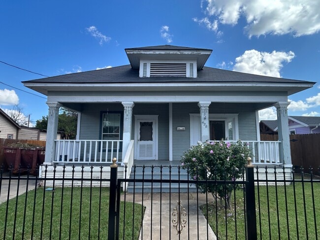
Property Record
428 W 7Th St, Dallas, TX 75208

Current Lease Availabilities
NEARBY LISTINGS FOR SALE OR LEASE
Property Detail
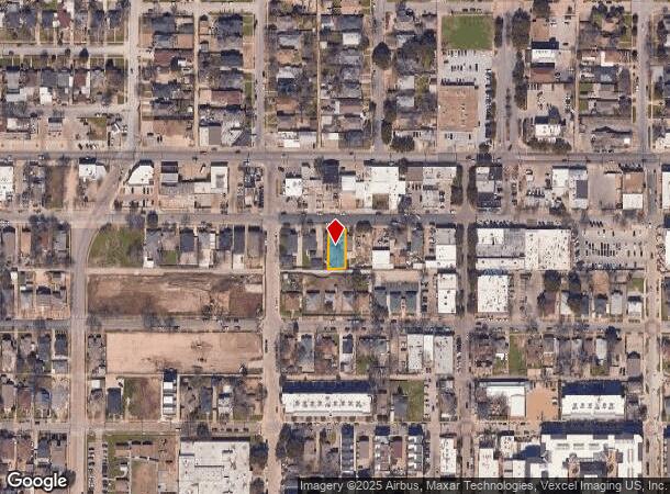
428 W 7Th St
Dallas-Fort Worth-Arlington, TX
Hillside
00000254791000000
HILLSIDE BLK 3/3143 LOT 18 INT202500077779 DD04032025 CO-DC 3143 003 01800 2003143 003
Sfr
Dallas
X
Texas
48113C0480K
18
2024
0.13 AC
2025
Eastern Lonestar/Tpke
004700
Dallas/Ft Worth
1,393 SF
DEMOGRAPHICS near 428 W 7Th St
1 mile
3 mile
5 mile
2024 Total Population
20,821
143,027
378,970
2029 Population
21,299
144,453
383,483
Pop Growth 2024-2029
+ 2.30%
+ 1.00%
+ 1.19%
Average Age
37
37
37
2024 Total Households
8,007
52,164
155,436
HH Growth 2024-2029
+ 2.34%
+ 1.51%
+ 1.45%
Median Household Inc
$70,048
$68,544
$69,360
Avg Household Size
2.50
2.60
2.30
2024 Avg HH Vehicles
2.00
2.00
2.00
Median Home Value
$479,687
$297,942
$279,146
Median Year Built
1957
1962
1984
Nearby Places
Map Layers
Map Styles
 Street
 Aerial
Transit
 Traffic
 Biking
Places
Listings with unknown addresses are not visible on the map
- Restaurants
- Banks
- Shops
- Fitness
- Groceries
PUBLIC TRANSPORTATION
COMMUTER RAIL
Drive
Walk
Distance
8 min
3.9 mi
Drive
Walk
Distance
12 min
6.5 mi
AIRPORT
Dallas Love Field
Drive
Walk
Distance
Dallas Love Field
19 min
8.9 mi
Dallas-Fort Worth International
Drive
Walk
Distance
Dallas-Fort Worth International
32 min
23.0 mi
Nearby Properties
Address
Land Use
TOTAL SIZE
Lot Size
Zoning
Address
Land Use
TOTAL SIZE
Lot Size
Zoning
1,298,826 SF
33.16 AC
Z163
Address
Land Use
TOTAL SIZE
Lot Size
Zoning
1,308,710 SF
8.42 AC
Z21
Address
Land Use
TOTAL SIZE
Lot Size
Zoning
1,480,246 SF
1.86 AC
Z21
Address
Land Use
TOTAL SIZE
Lot Size
Zoning
1,424,070 SF
1.36 AC
Z21
Address
Land Use
TOTAL SIZE
Lot Size
Zoning
893,159 SF
1.17 AC
Z21
Address
Land Use
TOTAL SIZE
Lot Size
Zoning
857,292 SF
1.47 AC
Z239
Address
Land Use
TOTAL SIZE
Lot Size
Zoning
1,682,440 SF
1.44 AC
Z96
Address
Land Use
TOTAL SIZE
Lot Size
Zoning
784,725 SF
2.33 AC
Z239
Address
Land Use
TOTAL SIZE
Lot Size
Zoning
180,000 SF
4.66 AC
Z116
Address
Land Use
TOTAL SIZE
Lot Size
Zoning
858,120 SF
2.21 AC
Z21
Address
Land Use
TOTAL SIZE
Lot Size
Zoning
2,326,857 SF
4.43 AC
Z21
Address
Land Use
TOTAL SIZE
Lot Size
Zoning
1,912,762 SF
1.54 AC
Z21
Address
Land Use
TOTAL SIZE
Lot Size
Zoning
1,979,594 SF
1.81 AC
Z21
Address
Land Use
TOTAL SIZE
Lot Size
Zoning
307,597 SF
15.21 AC
Z116
Address
Land Use
TOTAL SIZE
Lot Size
Zoning
1,173,721 SF
1.22 AC
Z21
Address
Land Use
TOTAL SIZE
Lot Size
Zoning
1,018,066 SF
1.20 AC
Z21
Address
Land Use
TOTAL SIZE
Lot Size
Zoning
741,673 SF
1.30 AC
Z21
Address
Land Use
TOTAL SIZE
Lot Size
Zoning
732,117 SF
5 AC
Z239
Address
Land Use
TOTAL SIZE
Lot Size
Zoning
600,907 SF
3.88 AC
Z239
Address
Land Use
TOTAL SIZE
Lot Size
Zoning
724,888 SF
2.59 AC
Address
Land Use
TOTAL SIZE
Lot Size
Zoning
26,896 SF
3.56 AC
Z239
Address
Land Use
TOTAL SIZE
Lot Size
Zoning
466,620 SF
1.52 AC
Z239
Address
Land Use
TOTAL SIZE
Lot Size
Zoning
316,447 SF
12.61 AC
Z164
Address
Land Use
TOTAL SIZE
Lot Size
Zoning
1,974,033 SF
1.67 AC
Z21
Address
Land Use
TOTAL SIZE
Lot Size
Zoning
510,277 SF
1.67 AC
Z239
Address
Land Use
TOTAL SIZE
Lot Size
Zoning
1,083,196 SF
6.13 AC
Z21
Address
Land Use
TOTAL SIZE
Lot Size
Zoning
179,370 SF
13.18 AC
Z248
Address
Land Use
TOTAL SIZE
Lot Size
Zoning
419,729 SF
3.62 AC
Z115
Address
Land Use
TOTAL SIZE
Lot Size
Zoning
452,834 SF
2.76 AC
Z21
Address
Land Use
TOTAL SIZE
Lot Size
Zoning
1,137,345 SF
0.83 AC
Z21
The World's #1 Commercial Real Estate Marketplace
Connect with us
© 2026 CoStar Group
The information above has been obtained from sources believed reliable. While we do not doubt its accuracy we have not verified it and make no guarantee, warranty or representation about it. It is your responsibility to independently confirm its accuracy and completeness. Any projections, opinions, assumptions, or estimates used are for example only and do not represent the current or future performance of the property. The value of this transaction to you depends on tax and other factors which should be evaluated by your tax, financial, and legal advisors. You and your advisors should conduct a careful, independent investigation of the property to determine to your satisfaction the suitability of the property for your needs.