Property Record
4285 E Range Ct, Saint Clair, MI 48079


Property Detail
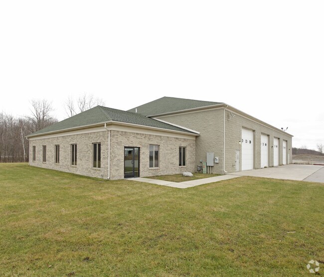
4285 E Range Ct
30-038-4003-650
BEG N 85D 13M E 1352' & S 2D 14M 55S E 330.29' FROM W 1/4 COR, TH S 2D 14M 55S E 660.58' TH S 85D 13M W 336.65', TH N 2D 30M W 660.46', TH N 85D 13M E 339.55' TO BEG SECTION 18 T5N R17E 5.12 A
Warehouse
Saint Clair
I-1
Michigan
B and X Area of moderate flood hazard, usually the area between the limits of the 100-year and 500-year floods.
5.12 AC
2025
St Clair & Lapeer Counties
2025
Detroit
640100
Detroit-Warren-Dearborn, MI
11,520 SF
NEARBY LISTINGS FOR SALE OR LEASE
DEMOGRAPHICS near 4285 E Range Ct
1 mile
3 mile
5 mile
2025 Total Population
1,018
11,384
24,720
2030 Population
1,049
11,449
24,757
Pop Growth 2025-2030
+ 3.05%
+ 0.57%
+ 0.15%
Average Age
44
45
44
2025 Total Households
394
4,925
10,321
HH Growth 2025-2030
+ 2.79%
+ 0.49%
+ 0.07%
Median Household Inc
$88,109
$70,283
$72,619
Avg Household Size
2.50
2.30
2.30
2025 Avg HH Vehicles
2.00
2.00
2.00
Median Home Value
$281,666
$249,586
$238,583
Median Year Built
1991
1979
1978
Nearby Places
Map Layers
Map Styles
 Street
 Aerial
Transit
 Traffic
 Biking
Places
Listings with unknown addresses are not visible on the map
- Restaurants
- Banks
- Shops
- Fitness
- Groceries
PUBLIC TRANSPORTATION
COMMUTER RAIL
Drive
Walk
Distance
15 min
8.2 mi
Nearby Properties
Address
Land Use
TOTAL SIZE
Lot Size
Zoning
Address
Land Use
TOTAL SIZE
Lot Size
Zoning
720,000 SF
Address
Land Use
TOTAL SIZE
Lot Size
Zoning
369,800 SF
Address
Land Use
TOTAL SIZE
Lot Size
Zoning
682,515 SF
211.45 AC
M-2
Address
Land Use
TOTAL SIZE
Lot Size
Zoning
79,276 SF
316.65 AC
M-1
Address
Land Use
TOTAL SIZE
Lot Size
Zoning
1,246,586 SF
83.70 AC
M-2
Address
Land Use
TOTAL SIZE
Lot Size
Zoning
98,904 SF
29.48 AC
R1-A
Address
Land Use
TOTAL SIZE
Lot Size
Zoning
79,276 SF
311.74 AC
M-1
Address
Land Use
TOTAL SIZE
Lot Size
Zoning
98,736 SF
8.49 AC
RM
Address
Land Use
TOTAL SIZE
Lot Size
Zoning
204,347 SF
35.13 AC
C-2
Address
Land Use
TOTAL SIZE
Lot Size
Zoning
80,662 SF
R1-A
Address
Land Use
TOTAL SIZE
Lot Size
Zoning
138,360 SF
6.01 AC
M-1
Address
Land Use
TOTAL SIZE
Lot Size
Zoning
Address
Land Use
TOTAL SIZE
Lot Size
Zoning
133,345 SF
11.69 AC
M-1 LIGHT
Address
Land Use
TOTAL SIZE
Lot Size
Zoning
108,767 SF
7.29 AC
R1-A
Address
Land Use
TOTAL SIZE
Lot Size
Zoning
83,623 SF
5.49 AC
M-1
Address
Land Use
TOTAL SIZE
Lot Size
Zoning
250,775 SF
11.29 AC
M-1
Address
Land Use
TOTAL SIZE
Lot Size
Zoning
137,000 SF
11.14 AC
M-1 LIGHT
Address
Land Use
TOTAL SIZE
Lot Size
Zoning
112,486 SF
11.91 AC
M-1 LIGHT
Address
Land Use
TOTAL SIZE
Lot Size
Zoning
53,291 SF
Address
Land Use
TOTAL SIZE
Lot Size
Zoning
100,096 SF
13.85 AC
M-2
Address
Land Use
TOTAL SIZE
Lot Size
Zoning
30.80 AC
R-3 MLTPLE
Address
Land Use
TOTAL SIZE
Lot Size
Zoning
50,314 SF
58.60 AC
M-2
Address
Land Use
TOTAL SIZE
Lot Size
Zoning
68,348 SF
6.33 AC
M-1
Address
Land Use
TOTAL SIZE
Lot Size
Zoning
9.60 AC
R-1 LOW DE
Address
Land Use
TOTAL SIZE
Lot Size
Zoning
54,096 SF
6.10 AC
R-1A MED D
Address
Land Use
TOTAL SIZE
Lot Size
Zoning
28,565 SF
R1-A
Address
Land Use
TOTAL SIZE
Lot Size
Zoning
5,213 SF
45 AC
I-2
Address
Land Use
TOTAL SIZE
Lot Size
Zoning
66,521 SF
5.78 AC
M-1 LIGHT
Address
Land Use
TOTAL SIZE
Lot Size
Zoning
55,760 SF
7.86 AC
M-1
Address
Land Use
TOTAL SIZE
Lot Size
Zoning
18,000 SF
9.62 AC
M-1
The World's #1 Commercial Real Estate Marketplace
Connect with us
© 2026 CoStar Group
The information above has been obtained from sources believed reliable. While we do not doubt its accuracy we have not verified it and make no guarantee, warranty or representation about it. It is your responsibility to independently confirm its accuracy and completeness. Any projections, opinions, assumptions, or estimates used are for example only and do not represent the current or future performance of the property. The value of this transaction to you depends on tax and other factors which should be evaluated by your tax, financial, and legal advisors. You and your advisors should conduct a careful, independent investigation of the property to determine to your satisfaction the suitability of the property for your needs.