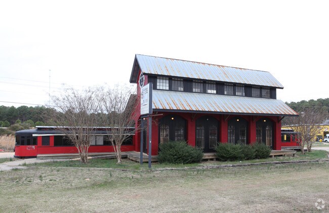
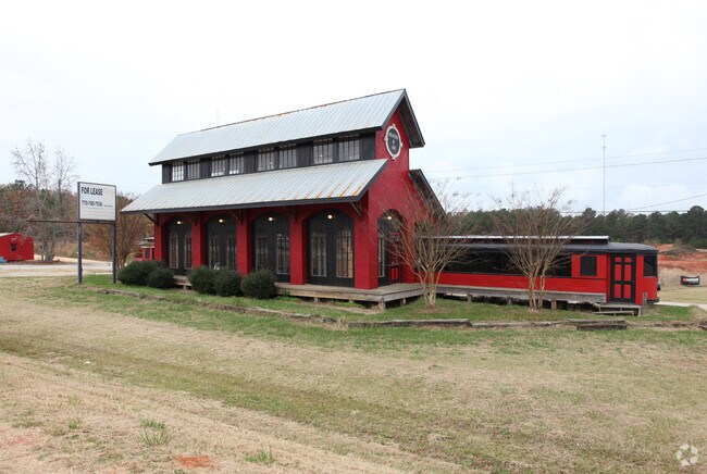
Property Record
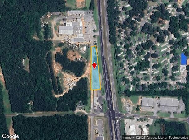
4287 N Expressway, Griffin, GA 30223
NEARBY LISTINGS FOR SALE OR LEASE
-
-
View all Griffin listings for sale on LoopNet.com
Property Detail
4287 N Expressway
241-02-003
US19/41 (4281 & 4287) 0.88 AC TR A PB 25/620
Storebuilding
Spalding
X
Georgia
13255C0060E
0.88 AC
2024
W Henry/Spalding
2024
Atlanta
160402
Atlanta-Sandy Springs-Roswell, GA
1,071 SF
DEMOGRAPHICS near 4287 N Expressway
1 Mile
3 Mile
5 Mile
2024 Total Population
1,855
11,991
33,853
2029 Population
1,981
12,953
36,430
Pop Growth 2024-2029
+ 6.79%
+ 8.02%
+ 7.61%
Average Age
37
37
40
2024 Total Households
638
4,075
12,151
HH Growth 2024-2029
+ 6.58%
+ 7.88%
+ 7.48%
Median Household Inc
$58,481
$61,632
$66,076
Avg Household Size
2.90
2.90
2.80
2024 Avg HH Vehicles
2.00
2.00
2.00
Median Home Value
$169,032
$185,480
$195,440
Median Year Built
1992
1995
1998
Nearby Places
Map Layers
Map Styles
 Street
 Aerial
- Restaurants
- Banks
- Shops
- Fitness
- Groceries
PUBLIC TRANSPORTATION
AIRPORT
Hartsfield - Jackson Atlanta International
DRIVE
WALK
Distance
Hartsfield - Jackson Atlanta International
38 min
23.9 mi
Freight Ports
Georgia Ports - Savannah
DRIVE
WALK
Distance
Georgia Ports - Savannah
256 min
221.8 mi
SALE & LEASE HISTORY
LISTING DATE
SALE/LEASE

Sep 24, 2016
For Sale
Apr 09, 2018
For Sale
Nearby Properties
Address
Land Use
TOTAL SIZE
Lot Size
Zoning
Address
Land Use
TOTAL SIZE
Lot Size
Zoning
1,424,654 SF
172.86 AC
Address
Land Use
TOTAL SIZE
Lot Size
Zoning
640,693 SF
691.83 AC
PD
Address
Land Use
TOTAL SIZE
Lot Size
Zoning
11,520 SF
8.77 AC
C-1B
Address
Land Use
TOTAL SIZE
Lot Size
Zoning
11,312 SF
560 AC
RA
Address
Land Use
TOTAL SIZE
Lot Size
Zoning
20 AC
AR-1
Address
Land Use
TOTAL SIZE
Lot Size
Zoning
41,568 SF
29.31 AC
M2
Address
Land Use
TOTAL SIZE
Lot Size
Zoning
1,404 SF
62.12 AC
RMH
Address
Land Use
TOTAL SIZE
Lot Size
Zoning
24,540 SF
26 AC
C1
Address
Land Use
TOTAL SIZE
Lot Size
Zoning
594 SF
4.08 AC
C-1B
Address
Land Use
TOTAL SIZE
Lot Size
Zoning
39,681 SF
6.19 AC
C2
Address
Land Use
TOTAL SIZE
Lot Size
Zoning
5,518 SF
11.39 AC
C-1
Address
Land Use
TOTAL SIZE
Lot Size
Zoning
19,500 SF
3.09 AC
C
Address
Land Use
TOTAL SIZE
Lot Size
Zoning
15,968 SF
2.96 AC
C2
Address
Land Use
TOTAL SIZE
Lot Size
Zoning
9,020 SF
3.30 AC
C1
Address
Land Use
TOTAL SIZE
Lot Size
Zoning
6,880 SF
7.89 AC
M2
Address
Land Use
TOTAL SIZE
Lot Size
Zoning
40,411 SF
47.18 AC
C1
Address
Land Use
TOTAL SIZE
Lot Size
Zoning
30.24 AC
M1
Address
Land Use
TOTAL SIZE
Lot Size
Zoning
40,536 SF
6 AC
Address
Land Use
TOTAL SIZE
Lot Size
Zoning
10,200 SF
8.35 AC
Address
Land Use
TOTAL SIZE
Lot Size
Zoning
308.50 AC
Address
Land Use
TOTAL SIZE
Lot Size
Zoning
23,233 SF
5 AC
Address
Land Use
TOTAL SIZE
Lot Size
Zoning
16,080 SF
2.91 AC
C2
Address
Land Use
TOTAL SIZE
Lot Size
Zoning
19,026 SF
4.75 AC
RA
Address
Land Use
TOTAL SIZE
Lot Size
Zoning
19,920 SF
4.10 AC
C3
Address
Land Use
TOTAL SIZE
Lot Size
Zoning
73,390 SF
6.35 AC
M2
Address
Land Use
TOTAL SIZE
Lot Size
Zoning
16,800 SF
2.66 AC
The World's #1 Commercial Real Estate Marketplace
Connect with us
© 2025 CoStar Group
The information above has been obtained from sources believed reliable. While we do not doubt its accuracy we have not verified it and make no guarantee, warranty or representation about it. It is your responsibility to independently confirm its accuracy and completeness. Any projections, opinions, assumptions, or estimates used are for example only and do not represent the current or future performance of the property. The value of this transaction to you depends on tax and other factors which should be evaluated by your tax, financial, and legal advisors. You and your advisors should conduct a careful, independent investigation of the property to determine to your satisfaction the suitability of the property for your needs.