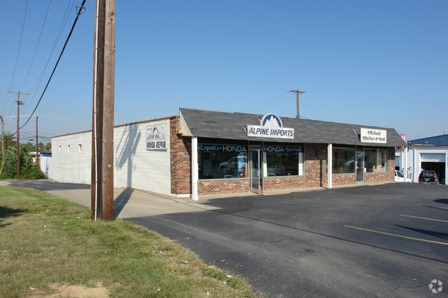
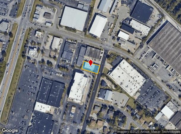
Property Record
429 Codell Dr, Lexington, KY 40509
NEARBY LISTINGS FOR SALE OR LEASE
Property Detail
429 Codell Dr
Lexington-Fayette, KY
Lakeview Industrial
10482864
A-366A LAKEVIEW INDUSTRIAL UNIT 1-B LOT 1A; BOOK: 3763 PAGE: 188
Storebuilding
Fayette
X
Kentucky
2100670139E
1a
2025
0.28 AC
2025
East Lexington/Fayette
003910
Lexington/Fayette
6,000 SF
DEMOGRAPHICS near 429 Codell Dr
1 Mile
3 Mile
5 Mile
2024 Total Population
12,954
102,240
223,940
2029 Population
12,962
102,208
223,924
Pop Growth 2024-2029
+ 0.06%
(0.03%)
(0.01%)
Average Age
36
38
38
2024 Total Households
5,751
44,303
96,770
HH Growth 2024-2029
+ 0.09%
0.00%
(0.01%)
Median Household Inc
$51,363
$57,911
$55,888
Avg Household Size
2.20
2.10
2.20
2024 Avg HH Vehicles
1.00
2.00
2.00
Median Home Value
$169,481
$277,850
$241,251
Median Year Built
1983
1978
1979
Nearby Places
Map Layers
Map Styles
 Street
 Aerial
- Restaurants
- Banks
- Shops
- Fitness
- Groceries
PUBLIC TRANSPORTATION
AIRPORT
Blue Grass
DRIVE
WALK
Distance
Blue Grass
24 min
14.7 mi
SALE & LEASE HISTORY
LISTING DATE
SALE/LEASE

Jan 23, 2023
For Lease
Nearby Properties
Address
Land Use
TOTAL SIZE
Lot Size
Zoning
Address
Land Use
TOTAL SIZE
Lot Size
Zoning
163,323 SF
31 AC
P-1
Address
Land Use
TOTAL SIZE
Lot Size
Zoning
582.34 AC
A-U
Address
Land Use
TOTAL SIZE
Lot Size
Zoning
76,441 SF
63.86 AC
A-U
Address
Land Use
TOTAL SIZE
Lot Size
Zoning
301,644 SF
38.07 AC
R-1C
Address
Land Use
TOTAL SIZE
Lot Size
Zoning
7,640 SF
9.04 AC
EAR-3
Address
Land Use
TOTAL SIZE
Lot Size
Zoning
156,270 SF
11.18 AC
R-1C
Address
Land Use
TOTAL SIZE
Lot Size
Zoning
19 AC
R-3
Address
Land Use
TOTAL SIZE
Lot Size
Zoning
9,746 SF
16.65 AC
R-4
Address
Land Use
TOTAL SIZE
Lot Size
Zoning
18.69 AC
R-3
Address
Land Use
TOTAL SIZE
Lot Size
Zoning
25,920 SF
23.71 AC
R-2
Address
Land Use
TOTAL SIZE
Lot Size
Zoning
64,617 SF
41.63 AC
B-6P
Address
Land Use
TOTAL SIZE
Lot Size
Zoning
8,208 SF
21.16 AC
R-3
Address
Land Use
TOTAL SIZE
Lot Size
Zoning
163,828 SF
17.69 AC
P-1
Address
Land Use
TOTAL SIZE
Lot Size
Zoning
57,974 SF
15.22 AC
B-6P
Address
Land Use
TOTAL SIZE
Lot Size
Zoning
24,174 SF
15.02 AC
R-3
Address
Land Use
TOTAL SIZE
Lot Size
Zoning
17.20 AC
R-4
Address
Land Use
TOTAL SIZE
Lot Size
Zoning
13.77 AC
R-4
Address
Land Use
TOTAL SIZE
Lot Size
Zoning
41.55 AC
ED
Address
Land Use
TOTAL SIZE
Lot Size
Zoning
42,642 SF
10.35 AC
B-6P
Address
Land Use
TOTAL SIZE
Lot Size
Zoning
4,868 SF
15.41 AC
R-3
Address
Land Use
TOTAL SIZE
Lot Size
Zoning
9,434 SF
16.28 AC
R-3
Address
Land Use
TOTAL SIZE
Lot Size
Zoning
28,776 SF
13.83 AC
B-1
Address
Land Use
TOTAL SIZE
Lot Size
Zoning
73,590 SF
13.31 AC
R-1T
Address
Land Use
TOTAL SIZE
Lot Size
Zoning
21,209 SF
R-4
Address
Land Use
TOTAL SIZE
Lot Size
Zoning
103,445 SF
18.39 AC
A-U
Address
Land Use
TOTAL SIZE
Lot Size
Zoning
133,750 SF
1.13 AC
B-2B
Address
Land Use
TOTAL SIZE
Lot Size
Zoning
267,060 SF
65 AC
R-3
Address
Land Use
TOTAL SIZE
Lot Size
Zoning
4,406 SF
28.12 AC
R-3
Address
Land Use
TOTAL SIZE
Lot Size
Zoning
25,608 SF
104.39 AC
I-1
Address
Land Use
TOTAL SIZE
Lot Size
Zoning
53,543 SF
9.78 AC
R-1C
The World's #1 Commercial Real Estate Marketplace
Connect with us
© 2026 CoStar Group
The information above has been obtained from sources believed reliable. While we do not doubt its accuracy we have not verified it and make no guarantee, warranty or representation about it. It is your responsibility to independently confirm its accuracy and completeness. Any projections, opinions, assumptions, or estimates used are for example only and do not represent the current or future performance of the property. The value of this transaction to you depends on tax and other factors which should be evaluated by your tax, financial, and legal advisors. You and your advisors should conduct a careful, independent investigation of the property to determine to your satisfaction the suitability of the property for your needs.