Property Record
429 Main St, Three Bridges, NJ 08887


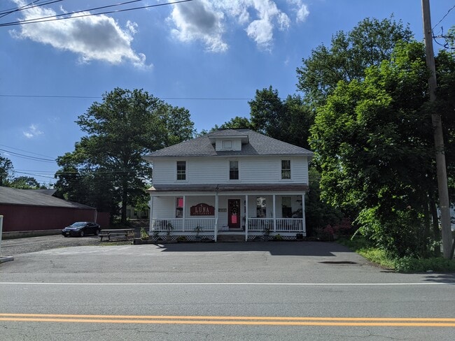
Property Detail
429 Main St
22-00083-0000-00010
Hunterdon
Restaurantbuilding
New Jersey
VC
10
B and X Area of moderate flood hazard, usually the area between the limits of the 100-year and 500-year floods.
0.25 AC
2024
Hunterdon
2025
Northern New Jersey
011202
Newark, NJ
3,040 SF
NEARBY LISTINGS FOR SALE OR LEASE
DEMOGRAPHICS near 429 Main St
1 mile
3 mile
5 mile
2025 Total Population
1,113
17,033
41,664
2030 Population
1,126
17,485
42,774
Pop Growth 2025-2030
+ 1.17%
+ 2.65%
+ 2.66%
Average Age
44
44
43
2025 Total Households
406
6,589
15,529
HH Growth 2025-2030
+ 1.23%
+ 2.76%
+ 2.70%
Median Household Inc
$155,263
$139,995
$148,931
Avg Household Size
2.70
2.50
2.60
2025 Avg HH Vehicles
2.00
2.00
2.00
Median Home Value
$621,244
$516,236
$581,882
Median Year Built
1981
1984
1983
Nearby Places
Map Layers
Map Styles
 Street
 Aerial
Layers
 Traffic
 Biking
Places
Listings with unknown addresses are not visible on the map
- Restaurants
- Banks
- Shops
- Fitness
- Groceries
PUBLIC TRANSPORTATION
COMMUTER RAIL
North Branch (Raritan Valley Line - NJ Transit Commuter Rail (NJ Transit))
Drive
Walk
Distance
North Branch (Raritan Valley Line - NJ Transit Commuter Rail (NJ Transit))
18 min
9.0 mi
AIRPORT
Trenton Mercer
Drive
Walk
Distance
Trenton Mercer
39 min
23.5 mi
Newark Liberty International
Drive
Walk
Distance
Newark Liberty International
56 min
44.2 mi
Lehigh Valley International
Drive
Walk
Distance
Lehigh Valley International
67 min
47.1 mi
Freight Ports
New York Container Terminal
Drive
Walk
Distance
New York Container Terminal
57 min
43.3 mi
SALE & LEASE HISTORY
LISTING DATE
SALE/LEASE

Oct 05, 2017
For Sale
Jun 05, 2020
For Sale
Nearby Properties
Address
Land Use
TOTAL SIZE
Lot Size
Zoning
Address
Land Use
TOTAL SIZE
Lot Size
Zoning
68.38 AC
P
Address
Land Use
TOTAL SIZE
Lot Size
Zoning
7.88 AC
CR
Address
Land Use
TOTAL SIZE
Lot Size
Zoning
39.32 AC
P
Address
Land Use
TOTAL SIZE
Lot Size
Zoning
19.85 AC
B-2
Address
Land Use
TOTAL SIZE
Lot Size
Zoning
20.89 AC
O/SS
Address
Land Use
TOTAL SIZE
Lot Size
Zoning
26.03 AC
I-2
Address
Land Use
TOTAL SIZE
Lot Size
Zoning
108.22 AC
I-2
Address
Land Use
TOTAL SIZE
Lot Size
Zoning
1,418 SF
19.67 AC
P
Address
Land Use
TOTAL SIZE
Lot Size
Zoning
16.01 AC
I-2
Address
Land Use
TOTAL SIZE
Lot Size
Zoning
38.30 AC
O-2
Address
Land Use
TOTAL SIZE
Lot Size
Zoning
7.09 AC
I-2
Address
Land Use
TOTAL SIZE
Lot Size
Zoning
9.34 AC
B-4
Address
Land Use
TOTAL SIZE
Lot Size
Zoning
12 AC
R-5
Address
Land Use
TOTAL SIZE
Lot Size
Zoning
2,360 SF
36.04 AC
I-2
Address
Land Use
TOTAL SIZE
Lot Size
Zoning
17.88 AC
O-2
Address
Land Use
TOTAL SIZE
Lot Size
Zoning
1,968 SF
5.99 AC
B-2
Address
Land Use
TOTAL SIZE
Lot Size
Zoning
14.32 AC
AG
Address
Land Use
TOTAL SIZE
Lot Size
Zoning
28.68 AC
I-2
Address
Land Use
TOTAL SIZE
Lot Size
Zoning
7.69 AC
I-2
Address
Land Use
TOTAL SIZE
Lot Size
Zoning
48,738 SF
4.44 AC
GA
Address
Land Use
TOTAL SIZE
Lot Size
Zoning
7.14 AC
PCOS
Address
Land Use
TOTAL SIZE
Lot Size
Zoning
6.46 AC
I-2
Address
Land Use
TOTAL SIZE
Lot Size
Zoning
8.50 AC
VR
Address
Land Use
TOTAL SIZE
Lot Size
Zoning
8.74 AC
I-2
Address
Land Use
TOTAL SIZE
Lot Size
Zoning
5,274 SF
3.93 AC
HR
Address
Land Use
TOTAL SIZE
Lot Size
Zoning
4.14 AC
B-2
Address
Land Use
TOTAL SIZE
Lot Size
Zoning
3.17 AC
P
Address
Land Use
TOTAL SIZE
Lot Size
Zoning
7.26 AC
I-2
Address
Land Use
TOTAL SIZE
Lot Size
Zoning
18.76 AC
I-2
Address
Land Use
TOTAL SIZE
Lot Size
Zoning
7.75 AC
R-3
The World's #1 Commercial Real Estate Marketplace
Connect with us
© 2026 CoStar Group
The information above has been obtained from sources believed reliable. While we do not doubt its accuracy we have not verified it and make no guarantee, warranty or representation about it. It is your responsibility to independently confirm its accuracy and completeness. Any projections, opinions, assumptions, or estimates used are for example only and do not represent the current or future performance of the property. The value of this transaction to you depends on tax and other factors which should be evaluated by your tax, financial, and legal advisors. You and your advisors should conduct a careful, independent investigation of the property to determine to your satisfaction the suitability of the property for your needs.