Property Record
429 Marlborough Rd, Glastonbury, CT 06033


NEARBY LISTINGS FOR SALE OR LEASE
-
-
View all Glastonbury listings for sale on LoopNet.com
Property Detail
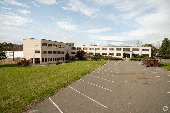
429 Marlborough Rd
GLAS-000008N-004240-W000008
Hartford
Governmentalpublicusegeneral
Connecticut
AE
w0008
09003C0553F
75.48 AC
2025
Glastonbury
2025
Hartford
520301
Hartford-West Hartford-East Hartford, CT
8,400 SF
DEMOGRAPHICS near 429 Marlborough Rd
1 Mile
3 Mile
5 Mile
2024 Total Population
1,174
7,385
26,392
2029 Population
1,169
7,358
26,261
Pop Growth 2024-2029
(0.43%)
(0.37%)
(0.50%)
Average Age
41
42
43
2024 Total Households
392
2,514
9,648
HH Growth 2024-2029
(0.26%)
(0.40%)
(0.55%)
Median Household Inc
$179,583
$167,908
$140,387
Avg Household Size
2.90
2.90
2.70
2024 Avg HH Vehicles
3.00
3.00
2.00
Median Home Value
$452,525
$405,603
$369,935
Median Year Built
1983
1981
1977
Nearby Places
Map Layers
Map Styles
 Street
 Aerial
- Restaurants
- Banks
- Shops
- Fitness
- Groceries
PUBLIC TRANSPORTATION
AIRPORT
Bradley International
DRIVE
WALK
Distance
Bradley International
56 min
30.7 mi
Freight Ports
Port of New Haven
DRIVE
WALK
Distance
Port of New Haven
69 min
46.7 mi
Nearby Properties
Address
Land Use
TOTAL SIZE
Lot Size
Zoning
Address
Land Use
TOTAL SIZE
Lot Size
Zoning
36,379 SF
10.98 AC
R
Address
Land Use
TOTAL SIZE
Lot Size
Zoning
6.07 AC
RR
Address
Land Use
TOTAL SIZE
Lot Size
Zoning
1,104.50 AC
RL
Address
Land Use
TOTAL SIZE
Lot Size
Zoning
239 AC
R-1
Address
Land Use
TOTAL SIZE
Lot Size
Zoning
156.99 AC
RR
Address
Land Use
TOTAL SIZE
Lot Size
Zoning
6.41 AC
RR
Address
Land Use
TOTAL SIZE
Lot Size
Zoning
19,240 SF
4.15 AC
DBIZ5
Address
Land Use
TOTAL SIZE
Lot Size
Zoning
75 AC
RR
Address
Land Use
TOTAL SIZE
Lot Size
Zoning
2.24 AC
Address
Land Use
TOTAL SIZE
Lot Size
Zoning
4,436 SF
4.66 AC
R
Address
Land Use
TOTAL SIZE
Lot Size
Zoning
217.83 AC
R
Address
Land Use
TOTAL SIZE
Lot Size
Zoning
11.54 AC
RR
Address
Land Use
TOTAL SIZE
Lot Size
Zoning
17,510 SF
5.76 AC
DBIZ5
Address
Land Use
TOTAL SIZE
Lot Size
Zoning
64.25 AC
CR
Address
Land Use
TOTAL SIZE
Lot Size
Zoning
Address
Land Use
TOTAL SIZE
Lot Size
Zoning
49.22 AC
Address
Land Use
TOTAL SIZE
Lot Size
Zoning
21,197 SF
4.52 AC
DBIZ
Address
Land Use
TOTAL SIZE
Lot Size
Zoning
21,142 SF
2.91 AC
DBIZ
Address
Land Use
TOTAL SIZE
Lot Size
Zoning
29.49 AC
RR
Address
Land Use
TOTAL SIZE
Lot Size
Zoning
77.37 AC
CR
Address
Land Use
TOTAL SIZE
Lot Size
Zoning
89.05 AC
RR
Address
Land Use
TOTAL SIZE
Lot Size
Zoning
Address
Land Use
TOTAL SIZE
Lot Size
Zoning
94.65 AC
RR
Address
Land Use
TOTAL SIZE
Lot Size
Zoning
1,465 SF
1,076 AC
R-1
Address
Land Use
TOTAL SIZE
Lot Size
Zoning
61.87 AC
RR
Address
Land Use
TOTAL SIZE
Lot Size
Zoning
7,086 SF
3.15 AC
DBIZ
Address
Land Use
TOTAL SIZE
Lot Size
Zoning
3,040 SF
36.20 AC
R
Address
Land Use
TOTAL SIZE
Lot Size
Zoning
7,728 SF
0.92 AC
GC
Address
Land Use
TOTAL SIZE
Lot Size
Zoning
4,600 SF
1.13 AC
DBIZ
The World's #1 Commercial Real Estate Marketplace
Connect with us
© 2025 CoStar Group
The information above has been obtained from sources believed reliable. While we do not doubt its accuracy we have not verified it and make no guarantee, warranty or representation about it. It is your responsibility to independently confirm its accuracy and completeness. Any projections, opinions, assumptions, or estimates used are for example only and do not represent the current or future performance of the property. The value of this transaction to you depends on tax and other factors which should be evaluated by your tax, financial, and legal advisors. You and your advisors should conduct a careful, independent investigation of the property to determine to your satisfaction the suitability of the property for your needs.