Property Record
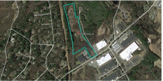
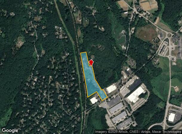
429 Whitney St, Northborough, MA 01532


This Property Is For Sale
NEARBY LISTINGS FOR SALE OR LEASE
Property Detail
429 Whitney St
NBOR-000150-000000-000009
Worcester
Pasture
Massachusetts
A
9
25027C0632F
15.72 AC
2025
Outlying Worcester
2025
Boston
740101
Worcester, MA-CT
DEMOGRAPHICS near 429 Whitney St
1 Mile
3 Mile
5 Mile
2024 Total Population
1,682
17,793
77,605
2029 Population
1,702
17,809
77,075
Pop Growth 2024-2029
+ 1.19%
+ 0.09%
(0.68%)
Average Age
43
43
41
2024 Total Households
619
6,726
30,203
HH Growth 2024-2029
+ 1.29%
+ 0.13%
(0.73%)
Median Household Inc
$122,077
$128,641
$106,445
Avg Household Size
2.70
2.60
2.50
2024 Avg HH Vehicles
2.00
2.00
2.00
Median Home Value
$592,715
$565,737
$474,590
Median Year Built
1989
1983
1973
Nearby Places
Map Layers
Map Styles
 Street
 Aerial
- Restaurants
- Banks
- Shops
- Fitness
- Groceries
PUBLIC TRANSPORTATION
COMMUTER RAIL
Westborough (Framingham/Worcester Line - Massachusetts Bay Transportation Authority Commuter Rail (Purple Line))
DRIVE
WALK
Distance
Westborough (Framingham/Worcester Line - Massachusetts Bay Transportation Authority Commuter Rail (Purple Line))
18 min
7.2 mi
Grafton (Framingham/Worcester Line - Massachusetts Bay Transportation Authority Commuter Rail (Purple Line))
DRIVE
WALK
Distance
Grafton (Framingham/Worcester Line - Massachusetts Bay Transportation Authority Commuter Rail (Purple Line))
20 min
9.5 mi
AIRPORT
Worcester Regional
DRIVE
WALK
Distance
Worcester Regional
30 min
18.3 mi
Freight Ports
Port of Boston
DRIVE
WALK
Distance
Port of Boston
58 min
41.5 mi
Nearby Properties
Address
Land Use
TOTAL SIZE
Lot Size
Zoning
Address
Land Use
TOTAL SIZE
Lot Size
Zoning
71.70 AC
LI
Address
Land Use
TOTAL SIZE
Lot Size
Zoning
339,553 SF
42.94 AC
RC
Address
Land Use
TOTAL SIZE
Lot Size
Zoning
18.73 AC
I
Address
Land Use
TOTAL SIZE
Lot Size
Zoning
24.39 AC
Address
Land Use
TOTAL SIZE
Lot Size
Zoning
554,193 SF
52.56 AC
I
Address
Land Use
TOTAL SIZE
Lot Size
Zoning
113.78 AC
I
Address
Land Use
TOTAL SIZE
Lot Size
Zoning
56.73 AC
LI
Address
Land Use
TOTAL SIZE
Lot Size
Zoning
260,605 SF
29 AC
I
Address
Land Use
TOTAL SIZE
Lot Size
Zoning
220,336 SF
24.65 AC
I
Address
Land Use
TOTAL SIZE
Lot Size
Zoning
209,220 SF
19.33 AC
I
Address
Land Use
TOTAL SIZE
Lot Size
Zoning
283,750 SF
27.03 AC
LI
Address
Land Use
TOTAL SIZE
Lot Size
Zoning
167,438 SF
23.82 AC
I
Address
Land Use
TOTAL SIZE
Lot Size
Zoning
47,301 SF
8.07 AC
Address
Land Use
TOTAL SIZE
Lot Size
Zoning
199,892 SF
46.51 AC
Address
Land Use
TOTAL SIZE
Lot Size
Zoning
136,790 SF
11.64 AC
B
Address
Land Use
TOTAL SIZE
Lot Size
Zoning
174,315 SF
29.04 AC
B
Address
Land Use
TOTAL SIZE
Lot Size
Zoning
118,128 SF
22.50 AC
I
Address
Land Use
TOTAL SIZE
Lot Size
Zoning
132,659 SF
11.67 AC
I
Address
Land Use
TOTAL SIZE
Lot Size
Zoning
143,126 SF
24.06 AC
I
Address
Land Use
TOTAL SIZE
Lot Size
Zoning
120,146 SF
7.33 AC
LI
Address
Land Use
TOTAL SIZE
Lot Size
Zoning
278,442 SF
5.68 AC
I
Address
Land Use
TOTAL SIZE
Lot Size
Zoning
83,180 SF
24 AC
I
Address
Land Use
TOTAL SIZE
Lot Size
Zoning
32,082 SF
3.70 AC
Address
Land Use
TOTAL SIZE
Lot Size
Zoning
10.70 AC
RR
Address
Land Use
TOTAL SIZE
Lot Size
Zoning
139,212 SF
21 AC
RB
Address
Land Use
TOTAL SIZE
Lot Size
Zoning
150,817 SF
28.60 AC
I
Address
Land Use
TOTAL SIZE
Lot Size
Zoning
200,358 SF
6.73 AC
B
Address
Land Use
TOTAL SIZE
Lot Size
Zoning
17.08 AC
LI
Address
Land Use
TOTAL SIZE
Lot Size
Zoning
8.51 AC
LI
Address
Land Use
TOTAL SIZE
Lot Size
Zoning
84,538 SF
6.85 AC
I
The World's #1 Commercial Real Estate Marketplace
Connect with us
© 2025 CoStar Group
The information above has been obtained from sources believed reliable. While we do not doubt its accuracy we have not verified it and make no guarantee, warranty or representation about it. It is your responsibility to independently confirm its accuracy and completeness. Any projections, opinions, assumptions, or estimates used are for example only and do not represent the current or future performance of the property. The value of this transaction to you depends on tax and other factors which should be evaluated by your tax, financial, and legal advisors. You and your advisors should conduct a careful, independent investigation of the property to determine to your satisfaction the suitability of the property for your needs.