No Photo
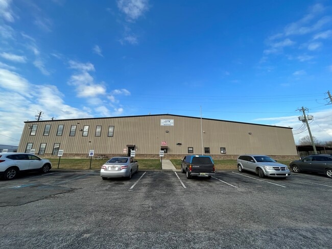
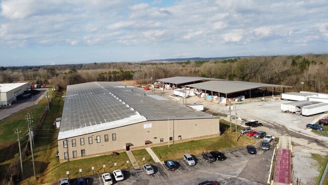
Property Record
4290 Alatex Rd, Montgomery, AL 36108

NEARBY LISTINGS FOR SALE OR LEASE
Property Detail
4290 Alatex Rd
Montgomery, AL
Dannelly Park 3
14-03-06-2-000-016.000
S 300 FT 1403062000016000
Manufacturinglight
Montgomery
X
Alabama
01101C0183J
aa
2025
7.70 AC
2025
South Montgomery
006000
Montgomery
92,000 SF
DEMOGRAPHICS near 4290 Alatex Rd
1 Mile
3 Mile
5 Mile
2024 Total Population
313
2,862
13,534
2029 Population
301
2,780
13,530
Pop Growth 2024-2029
(3.83%)
(2.87%)
(0.03%)
Average Age
43
44
41
2024 Total Households
121
1,156
5,457
HH Growth 2024-2029
(3.31%)
(2.77%)
(0.11%)
Median Household Inc
$32,727
$41,518
$30,812
Avg Household Size
2.60
2.50
2.40
2024 Avg HH Vehicles
2.00
2.00
2.00
Median Home Value
$63,043
$81,650
$78,127
Median Year Built
1971
1974
1974
Nearby Places
Map Layers
Map Styles
 Street
 Aerial
- Restaurants
- Banks
- Shops
- Fitness
- Groceries
PUBLIC TRANSPORTATION
AIRPORT
Montgomery Regional (Dannelly Field)
DRIVE
WALK
Distance
Montgomery Regional (Dannelly Field)
4 min
1.4 mi
SALE & LEASE HISTORY
LISTING DATE
SALE/LEASE

Feb 08, 2022
For Sale
Aug 24, 2022
For Lease
Nearby Properties
Address
Land Use
TOTAL SIZE
Lot Size
Zoning
Address
Land Use
TOTAL SIZE
Lot Size
Zoning
263,526 SF
110.10 AC
M-1
Address
Land Use
TOTAL SIZE
Lot Size
Zoning
858,004 SF
61.22 AC
M-1
Address
Land Use
TOTAL SIZE
Lot Size
Zoning
657,684 SF
59 AC
M-1
Address
Land Use
TOTAL SIZE
Lot Size
Zoning
391,901 SF
13 AC
M-3
Address
Land Use
TOTAL SIZE
Lot Size
Zoning
325,084 SF
24.51 AC
M-1
Address
Land Use
TOTAL SIZE
Lot Size
Zoning
129,122 SF
9.60 AC
M-3
Address
Land Use
TOTAL SIZE
Lot Size
Zoning
146,238 SF
8.60 AC
M-1
Address
Land Use
TOTAL SIZE
Lot Size
Zoning
25,763 SF
4.40 AC
M-1
Address
Land Use
TOTAL SIZE
Lot Size
Zoning
48,414 SF
40 AC
Address
Land Use
TOTAL SIZE
Lot Size
Zoning
3,782 SF
165 AC
INST
Address
Land Use
TOTAL SIZE
Lot Size
Zoning
44,559 SF
10 AC
M-3
Address
Land Use
TOTAL SIZE
Lot Size
Zoning
171,222 SF
38.08 AC
M-3
Address
Land Use
TOTAL SIZE
Lot Size
Zoning
29,474 SF
5.05 AC
AGR-1
Address
Land Use
TOTAL SIZE
Lot Size
Zoning
961 SF
8 AC
M-3
Address
Land Use
TOTAL SIZE
Lot Size
Zoning
61,302 SF
11.95 AC
M-1
Address
Land Use
TOTAL SIZE
Lot Size
Zoning
50,760 SF
2.86 AC
M-1
Address
Land Use
TOTAL SIZE
Lot Size
Zoning
12.97 AC
M-3
Address
Land Use
TOTAL SIZE
Lot Size
Zoning
632 AC
Address
Land Use
TOTAL SIZE
Lot Size
Zoning
2,304 SF
4.70 AC
FH
Address
Land Use
TOTAL SIZE
Lot Size
Zoning
27,009 SF
20 AC
Address
Land Use
TOTAL SIZE
Lot Size
Zoning
8,750 SF
11.25 AC
Address
Land Use
TOTAL SIZE
Lot Size
Zoning
11,936 SF
8.70 AC
R-100
Address
Land Use
TOTAL SIZE
Lot Size
Zoning
28,924 SF
6.11 AC
Address
Land Use
TOTAL SIZE
Lot Size
Zoning
108,951 SF
3.49 AC
M-3
Address
Land Use
TOTAL SIZE
Lot Size
Zoning
11,760 SF
163 AC
INST
Address
Land Use
TOTAL SIZE
Lot Size
Zoning
40,514 SF
5 AC
M-1
Address
Land Use
TOTAL SIZE
Lot Size
Zoning
11,067 SF
18.06 AC
M-1
Address
Land Use
TOTAL SIZE
Lot Size
Zoning
42,440 SF
9.70 AC
M-1
Address
Land Use
TOTAL SIZE
Lot Size
Zoning
31,560 SF
6.80 AC
M-1
The World's #1 Commercial Real Estate Marketplace
Connect with us
© 2026 CoStar Group
The information above has been obtained from sources believed reliable. While we do not doubt its accuracy we have not verified it and make no guarantee, warranty or representation about it. It is your responsibility to independently confirm its accuracy and completeness. Any projections, opinions, assumptions, or estimates used are for example only and do not represent the current or future performance of the property. The value of this transaction to you depends on tax and other factors which should be evaluated by your tax, financial, and legal advisors. You and your advisors should conduct a careful, independent investigation of the property to determine to your satisfaction the suitability of the property for your needs.