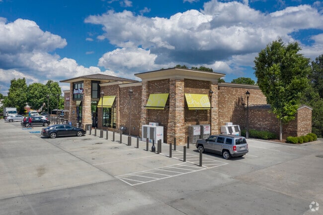
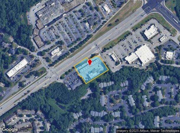
Property Record
4290 E East West Connector Se, Smyrna, GA 30082

NEARBY LISTINGS FOR SALE OR LEASE
Property Detail
4290 E East West Connector Se
Supermarket
Cobb
X
Georgia
13067C0209J
1.43 AC
2025
Powder Spring/Austell
2025
Atlanta
965800
Atlanta-Sandy Springs-Roswell, GA
6,201 SF
17-0620-0-078-0
DEMOGRAPHICS near 4290 E East West Connector Se
1 Mile
3 Mile
5 Mile
2024 Total Population
11,183
78,073
206,717
2029 Population
11,337
79,853
211,770
Pop Growth 2024-2029
+ 1.38%
+ 2.28%
+ 2.44%
Average Age
40
38
37
2024 Total Households
5,331
35,633
91,030
HH Growth 2024-2029
+ 1.22%
+ 2.32%
+ 2.45%
Median Household Inc
$120,811
$107,751
$87,177
Avg Household Size
2.10
2.20
2.20
2024 Avg HH Vehicles
2.00
2.00
2.00
Median Home Value
$442,827
$409,590
$372,462
Median Year Built
2001
1995
1989
Nearby Places
Map Layers
Map Styles
 Street
 Aerial
- Restaurants
- Banks
- Shops
- Fitness
- Groceries
PUBLIC TRANSPORTATION
COMMUTER RAIL
Atlanta (Crescent - Amtrak)
DRIVE
WALK
Distance
Atlanta (Crescent - Amtrak)
18 min
8.6 mi
AIRPORT
Hartsfield - Jackson Atlanta International
DRIVE
WALK
Distance
Hartsfield - Jackson Atlanta International
31 min
21.2 mi
Freight Ports
Georgia Ports - Savannah
DRIVE
WALK
Distance
Georgia Ports - Savannah
294 min
260.5 mi
Nearby Properties
Address
Land Use
TOTAL SIZE
Lot Size
Zoning
Address
Land Use
TOTAL SIZE
Lot Size
Zoning
3,929,999 SF
32.70 AC
OHR
Address
Land Use
TOTAL SIZE
Lot Size
Zoning
173,430 SF
13.83 AC
PVC
Address
Land Use
TOTAL SIZE
Lot Size
Zoning
394,294 SF
21.56 AC
OHR
Address
Land Use
TOTAL SIZE
Lot Size
Zoning
5.36 AC
RRC
Address
Land Use
TOTAL SIZE
Lot Size
Zoning
468,079 SF
31.79 AC
RMR
Address
Land Use
TOTAL SIZE
Lot Size
Zoning
16,408 SF
8.97 AC
PVC
Address
Land Use
TOTAL SIZE
Lot Size
Zoning
483,147 SF
29.70 AC
RM-16
Address
Land Use
TOTAL SIZE
Lot Size
Zoning
560,836 SF
60.28 AC
RM-8
Address
Land Use
TOTAL SIZE
Lot Size
Zoning
424,402 SF
34.46 AC
RM-12
Address
Land Use
TOTAL SIZE
Lot Size
Zoning
3.25 AC
MU
Address
Land Use
TOTAL SIZE
Lot Size
Zoning
504,744 SF
44.36 AC
RM-12
Address
Land Use
TOTAL SIZE
Lot Size
Zoning
452,107 SF
37.95 AC
RM-12
Address
Land Use
TOTAL SIZE
Lot Size
Zoning
347,150 SF
19.99 AC
RM-16
Address
Land Use
TOTAL SIZE
Lot Size
Zoning
329,385 SF
15.29 AC
RHR
Address
Land Use
TOTAL SIZE
Lot Size
Zoning
285,395 SF
26.58 AC
RM-12
Address
Land Use
TOTAL SIZE
Lot Size
Zoning
651,741 SF
3.66 AC
OI
Address
Land Use
TOTAL SIZE
Lot Size
Zoning
374,698 SF
30.72 AC
RM-12
Address
Land Use
TOTAL SIZE
Lot Size
Zoning
439,167 SF
41.13 AC
RM-12
Address
Land Use
TOTAL SIZE
Lot Size
Zoning
477,544 SF
4.61 AC
MU
Address
Land Use
TOTAL SIZE
Lot Size
Zoning
281,632 SF
27.12 AC
RM-12
Address
Land Use
TOTAL SIZE
Lot Size
Zoning
403,687 SF
42.37 AC
RM-12
Address
Land Use
TOTAL SIZE
Lot Size
Zoning
538,535 SF
32.40 AC
I2
Address
Land Use
TOTAL SIZE
Lot Size
Zoning
918,639 SF
7.92 AC
OI
Address
Land Use
TOTAL SIZE
Lot Size
Zoning
207,090 SF
24.40 AC
RM-12
Address
Land Use
TOTAL SIZE
Lot Size
Zoning
74,592 SF
9.83 AC
OS
Address
Land Use
TOTAL SIZE
Lot Size
Zoning
415,834 SF
17.62 AC
I2
Address
Land Use
TOTAL SIZE
Lot Size
Zoning
258,397 SF
22 AC
RM-12
Address
Land Use
TOTAL SIZE
Lot Size
Zoning
307,837 SF
3.43 AC
PVC
Address
Land Use
TOTAL SIZE
Lot Size
Zoning
313,882 SF
22.33 AC
RM-12
Address
Land Use
TOTAL SIZE
Lot Size
Zoning
319,840 SF
27.79 AC
RM-12
The World's #1 Commercial Real Estate Marketplace
Connect with us
© 2025 CoStar Group
The information above has been obtained from sources believed reliable. While we do not doubt its accuracy we have not verified it and make no guarantee, warranty or representation about it. It is your responsibility to independently confirm its accuracy and completeness. Any projections, opinions, assumptions, or estimates used are for example only and do not represent the current or future performance of the property. The value of this transaction to you depends on tax and other factors which should be evaluated by your tax, financial, and legal advisors. You and your advisors should conduct a careful, independent investigation of the property to determine to your satisfaction the suitability of the property for your needs.