Property Record
4290 Radio Dr, Saint Paul, MN 55129

NEARBY LISTINGS FOR SALE OR LEASE
-
-
View all Saint Paul listings for sale on LoopNet.com
Property Detail
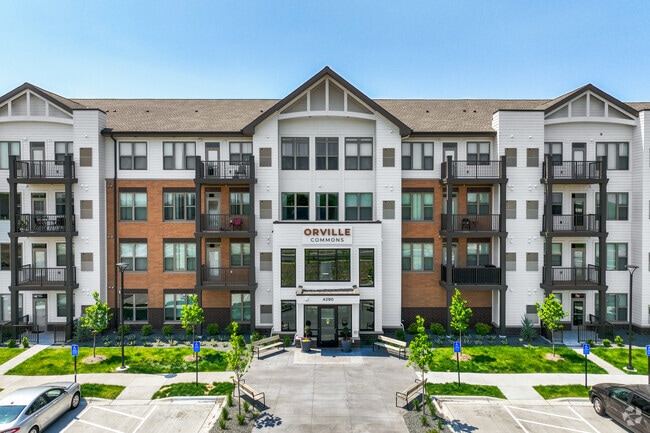
4290 Radio Dr
Minneapolis-St. Paul-Bloomington, MN-WI
Orville Commons
29-028-21-14-0011
BLOCK 1 LOT 3 SUBDIVISIONCD 3489 SUBDIVISIONNAME ORVILLE COMMONS
Apartment
Washington
2025
Minnesota
2024
3
071019
Woodbury/Afton/Lake Elmo
244,431 SF
Minneapolis/St Paul
DEMOGRAPHICS near 4290 Radio Dr
1 Mile
3 Mile
5 Mile
2024 Total Population
7,082
57,400
160,341
2029 Population
7,807
62,635
171,460
Pop Growth 2024-2029
+ 10.24%
+ 9.12%
+ 6.93%
Average Age
42
39
38
2024 Total Households
2,661
20,430
58,113
HH Growth 2024-2029
+ 10.75%
+ 9.20%
+ 6.94%
Median Household Inc
$119,581
$118,197
$103,165
Avg Household Size
2.50
2.70
2.70
2024 Avg HH Vehicles
2.00
2.00
2.00
Median Home Value
$405,620
$403,359
$352,010
Median Year Built
2004
1994
1991
Nearby Places
Map Layers
Map Styles
 Street
 Aerial
- Restaurants
- Banks
- Shops
- Fitness
- Groceries
PUBLIC TRANSPORTATION
AIRPORT
Minneapolis-St Paul International/Wold-Chamberlain
DRIVE
WALK
Distance
Minneapolis-St Paul International/Wold-Chamberlain
26 min
16.3 mi
Freight Ports
Port Milwaukee
DRIVE
WALK
Distance
Port Milwaukee
359 min
325.5 mi
Nearby Properties
Address
Land Use
TOTAL SIZE
Lot Size
Zoning
Address
Land Use
TOTAL SIZE
Lot Size
Zoning
114,777 SF
22.45 AC
Address
Land Use
TOTAL SIZE
Lot Size
Zoning
300,591 SF
62.48 AC
Address
Land Use
TOTAL SIZE
Lot Size
Zoning
243,476 SF
14.87 AC
Address
Land Use
TOTAL SIZE
Lot Size
Zoning
15.11 AC
Address
Land Use
TOTAL SIZE
Lot Size
Zoning
296,529 SF
31.80 AC
Address
Land Use
TOTAL SIZE
Lot Size
Zoning
3.63 AC
Address
Land Use
TOTAL SIZE
Lot Size
Zoning
5.77 AC
Address
Land Use
TOTAL SIZE
Lot Size
Zoning
178,623 SF
117.93 AC
Address
Land Use
TOTAL SIZE
Lot Size
Zoning
196,078 SF
31.29 AC
Address
Land Use
TOTAL SIZE
Lot Size
Zoning
551,440 SF
25.40 AC
Address
Land Use
TOTAL SIZE
Lot Size
Zoning
230,892 SF
43.62 AC
Address
Land Use
TOTAL SIZE
Lot Size
Zoning
77,566 SF
40 AC
Address
Land Use
TOTAL SIZE
Lot Size
Zoning
121,705 SF
35 AC
Address
Land Use
TOTAL SIZE
Lot Size
Zoning
71,164 SF
10.79 AC
Address
Land Use
TOTAL SIZE
Lot Size
Zoning
78,278 SF
4.08 AC
Address
Land Use
TOTAL SIZE
Lot Size
Zoning
80,019 SF
10.21 AC
Address
Land Use
TOTAL SIZE
Lot Size
Zoning
52,294 SF
6.47 AC
Address
Land Use
TOTAL SIZE
Lot Size
Zoning
42,342 SF
31.07 AC
Address
Land Use
TOTAL SIZE
Lot Size
Zoning
106,894 SF
5.88 AC
Address
Land Use
TOTAL SIZE
Lot Size
Zoning
50,246 SF
4.21 AC
Address
Land Use
TOTAL SIZE
Lot Size
Zoning
94,822 SF
34.92 AC
Address
Land Use
TOTAL SIZE
Lot Size
Zoning
123,226 SF
9.50 AC
Address
Land Use
TOTAL SIZE
Lot Size
Zoning
48,625 SF
4.73 AC
Address
Land Use
TOTAL SIZE
Lot Size
Zoning
394,016 SF
Address
Land Use
TOTAL SIZE
Lot Size
Zoning
97,205 SF
29.22 AC
Address
Land Use
TOTAL SIZE
Lot Size
Zoning
70,987 SF
8.88 AC
Address
Land Use
TOTAL SIZE
Lot Size
Zoning
38,488 SF
3.30 AC
Address
Land Use
TOTAL SIZE
Lot Size
Zoning
64,742 SF
3.56 AC
Address
Land Use
TOTAL SIZE
Lot Size
Zoning
70,534 SF
6.89 AC
The World's #1 Commercial Real Estate Marketplace
Connect with us
© 2026 CoStar Group
The information above has been obtained from sources believed reliable. While we do not doubt its accuracy we have not verified it and make no guarantee, warranty or representation about it. It is your responsibility to independently confirm its accuracy and completeness. Any projections, opinions, assumptions, or estimates used are for example only and do not represent the current or future performance of the property. The value of this transaction to you depends on tax and other factors which should be evaluated by your tax, financial, and legal advisors. You and your advisors should conduct a careful, independent investigation of the property to determine to your satisfaction the suitability of the property for your needs.