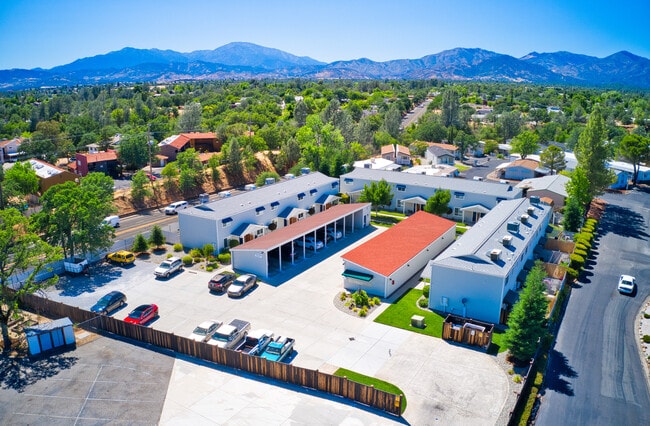
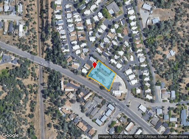
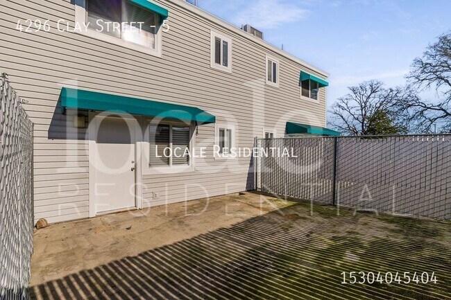
Property Record
4296 Clay St, Redding, CA 96003

NEARBY LISTINGS FOR SALE OR LEASE
Property Detail
4296 Clay St
113-240-004-000
Parcel Map 123 77 For Robert T Zackrey
Multifamilydwelling
Shasta
X
California
06089C1537G
0.93 AC
2024
Redding/Chico
2025
Other Market Areas
010704
Redding, CA
16,200 SF
DEMOGRAPHICS near 4296 Clay St
1 mile
3 mile
5 mile
2024 Total Population
7,520
43,357
92,518
2029 Population
7,554
43,567
92,675
Pop Growth 2024-2029
+ 0.45%
+ 0.48%
+ 0.17%
Average Age
42
42
41
2024 Total Households
3,417
18,635
37,667
HH Growth 2024-2029
+ 0.32%
+ 0.51%
+ 0.20%
Median Household Inc
$48,550
$55,732
$59,700
Avg Household Size
2.10
2.20
2.40
2024 Avg HH Vehicles
2.00
2.00
2.00
Median Home Value
$130,500
$336,193
$329,054
Median Year Built
1981
1983
1982
Nearby Places
Map Layers
Map Styles
 Street
 Aerial
Transit
 Traffic
 Biking
Places
Listings with unknown addresses are not visible on the map
- Restaurants
- Banks
- Shops
- Fitness
- Groceries
PUBLIC TRANSPORTATION
COMMUTER RAIL
Redding Amtrak (Coast Starlight - Amtrak)
Drive
Walk
Distance
Redding Amtrak (Coast Starlight - Amtrak)
6 min
3.1 mi
AIRPORT
Redding Regional
Drive
Walk
Distance
Redding Regional
16 min
10.9 mi
Freight Ports
Port of Richmond
Drive
Walk
Distance
Port of Richmond
234 min
207.3 mi
SALE & LEASE HISTORY
LISTING DATE
SALE/LEASE

Jun 21, 2021
For Sale
Nearby Properties
Address
Land Use
TOTAL SIZE
Lot Size
Zoning
Address
Land Use
TOTAL SIZE
Lot Size
Zoning
69.43 AC
Address
Land Use
TOTAL SIZE
Lot Size
Zoning
2.60 AC
Address
Land Use
TOTAL SIZE
Lot Size
Zoning
6.36 AC
Address
Land Use
TOTAL SIZE
Lot Size
Zoning
71,579 SF
4.37 AC
Address
Land Use
TOTAL SIZE
Lot Size
Zoning
72,875 SF
3.93 AC
Address
Land Use
TOTAL SIZE
Lot Size
Zoning
31,365 SF
1.33 AC
Address
Land Use
TOTAL SIZE
Lot Size
Zoning
39.85 AC
Address
Land Use
TOTAL SIZE
Lot Size
Zoning
8.22 AC
Address
Land Use
TOTAL SIZE
Lot Size
Zoning
Address
Land Use
TOTAL SIZE
Lot Size
Zoning
1,920 SF
55.63 AC
Address
Land Use
TOTAL SIZE
Lot Size
Zoning
89,098 SF
7.24 AC
Address
Land Use
TOTAL SIZE
Lot Size
Zoning
54,720 SF
2.53 AC
Address
Land Use
TOTAL SIZE
Lot Size
Zoning
1,344 SF
49.50 AC
Address
Land Use
TOTAL SIZE
Lot Size
Zoning
21,089 SF
7 AC
Address
Land Use
TOTAL SIZE
Lot Size
Zoning
19,572 SF
5.94 AC
Address
Land Use
TOTAL SIZE
Lot Size
Zoning
31,526 SF
55.92 AC
Address
Land Use
TOTAL SIZE
Lot Size
Zoning
61,754 SF
1.73 AC
Address
Land Use
TOTAL SIZE
Lot Size
Zoning
10.27 AC
Address
Land Use
TOTAL SIZE
Lot Size
Zoning
1,500 SF
69.70 AC
Address
Land Use
TOTAL SIZE
Lot Size
Zoning
104,740 SF
23.54 AC
Address
Land Use
TOTAL SIZE
Lot Size
Zoning
95,645 SF
9.55 AC
Address
Land Use
TOTAL SIZE
Lot Size
Zoning
134,868 SF
0.57 AC
Address
Land Use
TOTAL SIZE
Lot Size
Zoning
2.42 AC
Address
Land Use
TOTAL SIZE
Lot Size
Zoning
2,821 SF
136.53 AC
Address
Land Use
TOTAL SIZE
Lot Size
Zoning
101,683 SF
8.48 AC
Address
Land Use
TOTAL SIZE
Lot Size
Zoning
54,811 SF
2.22 AC
Address
Land Use
TOTAL SIZE
Lot Size
Zoning
63,837 SF
0.69 AC
Address
Land Use
TOTAL SIZE
Lot Size
Zoning
46,705 SF
2 AC
Address
Land Use
TOTAL SIZE
Lot Size
Zoning
8,200 SF
55.72 AC
Address
Land Use
TOTAL SIZE
Lot Size
Zoning
125,402 SF
20.61 AC
The World's #1 Commercial Real Estate Marketplace
Connect with us
© 2026 CoStar Group
The information above has been obtained from sources believed reliable. While we do not doubt its accuracy we have not verified it and make no guarantee, warranty or representation about it. It is your responsibility to independently confirm its accuracy and completeness. Any projections, opinions, assumptions, or estimates used are for example only and do not represent the current or future performance of the property. The value of this transaction to you depends on tax and other factors which should be evaluated by your tax, financial, and legal advisors. You and your advisors should conduct a careful, independent investigation of the property to determine to your satisfaction the suitability of the property for your needs.