Property Record
4298 N Highway 20, Island Park, ID 83429
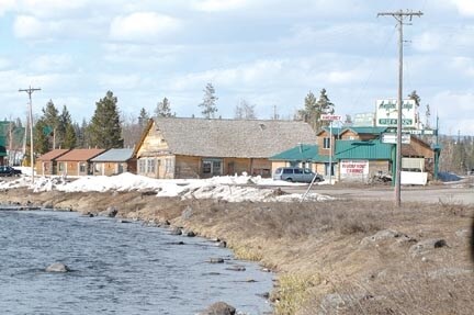

Property Detail
4298 N Highway 20
Rexburg, ID
ISLAND PARK TAX 2023-2024 SEC 36 TWP 14 RGE 43 (HENRYS FORK LANDING)
RP-I14N43363150
FREMONT
Commercialnec
Idaho
LID:MILIDU
9&10
2025
0.75 AC
2025
Idaho South Area
970100
Other Market Areas
NEARBY LISTINGS FOR SALE OR LEASE
-
-
View all Island Park listings for sale on LoopNet.com
DEMOGRAPHICS near 4298 N Highway 20
1 mile
3 mile
5 mile
2025 Total Population
36
359
542
2030 Population
40
400
605
Pop Growth 2025-2030
+ 11.11%
+ 11.42%
+ 11.62%
Average Age
51
51
51
2025 Total Households
16
161
243
HH Growth 2025-2030
+ 12.50%
+ 11.18%
+ 11.52%
Median Household Inc
$95,833
$89,338
$89,460
Avg Household Size
2.10
2.20
2.20
2025 Avg HH Vehicles
2.00
2.00
2.00
Median Home Value
$499,999
$514,925
$514,706
Median Year Built
1990
1990
1990
Nearby Places
Map Layers
Map Styles
 Street
 Aerial
Layers
 Traffic
 Biking
Places
Listings with unknown addresses are not visible on the map
- Restaurants
- Banks
- Shops
- Fitness
- Groceries
Nearby Properties
Address
Land Use
TOTAL SIZE
Lot Size
Zoning
Address
Land Use
TOTAL SIZE
Lot Size
Zoning
3.91 AC
LID:LIDU
Address
Land Use
TOTAL SIZE
Lot Size
Zoning
7.44 AC
LID:MILIDU
Address
Land Use
TOTAL SIZE
Lot Size
Zoning
Address
Land Use
TOTAL SIZE
Lot Size
Zoning
131.30 AC
LID:MILIDU
Address
Land Use
TOTAL SIZE
Lot Size
Zoning
1.18 AC
LID:MILIDU
Address
Land Use
TOTAL SIZE
Lot Size
Zoning
139.17 AC
LID:MILIDU
Address
Land Use
TOTAL SIZE
Lot Size
Zoning
768 SF
2.93 AC
Address
Land Use
TOTAL SIZE
Lot Size
Zoning
Address
Land Use
TOTAL SIZE
Lot Size
Zoning
Address
Land Use
TOTAL SIZE
Lot Size
Zoning
Address
Land Use
TOTAL SIZE
Lot Size
Zoning
Address
Land Use
TOTAL SIZE
Lot Size
Zoning
1.06 AC
LID:MILIDU
Address
Land Use
TOTAL SIZE
Lot Size
Zoning
0.55 AC
Address
Land Use
TOTAL SIZE
Lot Size
Zoning
2.64 AC
LID: LIDU
Address
Land Use
TOTAL SIZE
Lot Size
Zoning
1.67 AC
LID:MILIDU
Address
Land Use
TOTAL SIZE
Lot Size
Zoning
0.24 AC
Address
Land Use
TOTAL SIZE
Lot Size
Zoning
0.60 AC
LID:MILIDU
Address
Land Use
TOTAL SIZE
Lot Size
Zoning
0.40 AC
Address
Land Use
TOTAL SIZE
Lot Size
Zoning
Address
Land Use
TOTAL SIZE
Lot Size
Zoning
0.71 AC
LID:MILIDU
Address
Land Use
TOTAL SIZE
Lot Size
Zoning
Address
Land Use
TOTAL SIZE
Lot Size
Zoning
0.60 AC
Address
Land Use
TOTAL SIZE
Lot Size
Zoning
1.17 AC
Address
Land Use
TOTAL SIZE
Lot Size
Zoning
8.17 AC
LID:MILIDU
Address
Land Use
TOTAL SIZE
Lot Size
Zoning
0.39 AC
LID:MILIDU
Address
Land Use
TOTAL SIZE
Lot Size
Zoning
5.08 AC
Address
Land Use
TOTAL SIZE
Lot Size
Zoning
5.07 AC
Address
Land Use
TOTAL SIZE
Lot Size
Zoning
6.10 AC
Address
Land Use
TOTAL SIZE
Lot Size
Zoning
34.90 AC
The World's #1 Commercial Real Estate Marketplace
Connect with us
© 2026 CoStar Group
The information above has been obtained from sources believed reliable. While we do not doubt its accuracy we have not verified it and make no guarantee, warranty or representation about it. It is your responsibility to independently confirm its accuracy and completeness. Any projections, opinions, assumptions, or estimates used are for example only and do not represent the current or future performance of the property. The value of this transaction to you depends on tax and other factors which should be evaluated by your tax, financial, and legal advisors. You and your advisors should conduct a careful, independent investigation of the property to determine to your satisfaction the suitability of the property for your needs.