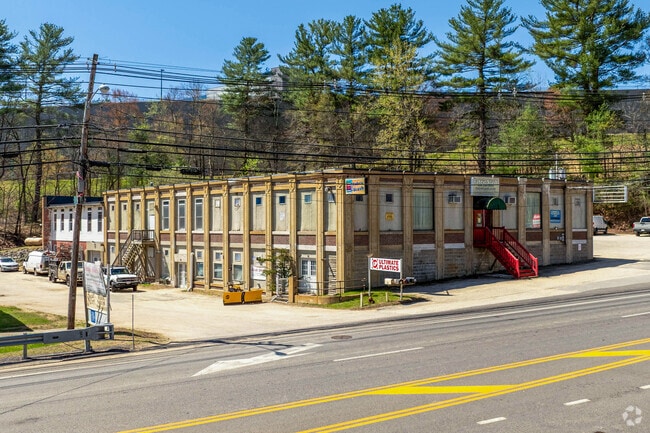
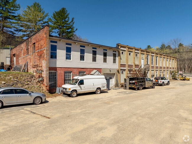
Property Record
45A Sturbridge Rd, Charlton, MA 01507
Current Lease Availabilities
NEARBY LISTINGS FOR SALE OR LEASE
Property Detail
45A Sturbridge Rd
CHAR-000027-D000000-000002
Worcester
Multipleuses
Massachusetts
A
2
25027C0769F
4.54 AC
2025
Outlying Worcester
2025
Boston
756101
Worcester, MA-CT
DEMOGRAPHICS near 45A Sturbridge Rd
1 Mile
3 Mile
5 Mile
2024 Total Population
615
7,491
27,942
2029 Population
602
7,401
27,752
Pop Growth 2024-2029
(2.11%)
(1.20%)
(0.68%)
Average Age
42
43
41
2024 Total Households
258
2,879
10,862
HH Growth 2024-2029
(2.33%)
(1.29%)
(0.75%)
Median Household Inc
$112,500
$107,353
$92,681
Avg Household Size
2.30
2.50
2.50
2024 Avg HH Vehicles
2.00
2.00
2.00
Median Home Value
$387,499
$399,167
$384,239
Median Year Built
1982
1980
1974
Nearby Places
- Restaurants
- Banks
- Shops
- Fitness
- Groceries
PUBLIC TRANSPORTATION
AIRPORT
Worcester Regional
DRIVE
WALK
Distance
Worcester Regional
29 min
14.3 mi
Bradley International
DRIVE
WALK
Distance
Bradley International
78 min
46.5 mi
Freight Ports
Port of Davisville, RI
DRIVE
WALK
Distance
Port of Davisville, RI
92 min
68.7 mi
Nearby Properties
Address
Land Use
TOTAL SIZE
Lot Size
Zoning
Address
Land Use
TOTAL SIZE
Lot Size
Zoning
1,800 SF
10.02 AC
IG
Address
Land Use
TOTAL SIZE
Lot Size
Zoning
15,648 SF
50.82 AC
A
Address
Land Use
TOTAL SIZE
Lot Size
Zoning
189,270 SF
97.55 AC
FB
Address
Land Use
TOTAL SIZE
Lot Size
Zoning
198,432 SF
91 AC
A
Address
Land Use
TOTAL SIZE
Lot Size
Zoning
104,471 SF
29.98 AC
A
Address
Land Use
TOTAL SIZE
Lot Size
Zoning
195.60 AC
IG
Address
Land Use
TOTAL SIZE
Lot Size
Zoning
118,826 SF
35.73 AC
IP
Address
Land Use
TOTAL SIZE
Lot Size
Zoning
22,593 SF
32.50 AC
R40
Address
Land Use
TOTAL SIZE
Lot Size
Zoning
63.02 AC
R40
Address
Land Use
TOTAL SIZE
Lot Size
Zoning
45.59 AC
IG
Address
Land Use
TOTAL SIZE
Lot Size
Zoning
19,511 SF
5.50 AC
V
Address
Land Use
TOTAL SIZE
Lot Size
Zoning
22,359 SF
3.09 AC
CB
Address
Land Use
TOTAL SIZE
Lot Size
Zoning
76,734 SF
7.75 AC
IG
Address
Land Use
TOTAL SIZE
Lot Size
Zoning
76.78 AC
IP
Address
Land Use
TOTAL SIZE
Lot Size
Zoning
2,267 SF
10 AC
A
Address
Land Use
TOTAL SIZE
Lot Size
Zoning
7,464 SF
73.37 AC
Address
Land Use
TOTAL SIZE
Lot Size
Zoning
22.15 AC
R40
Address
Land Use
TOTAL SIZE
Lot Size
Zoning
32,160 SF
7.10 AC
R40
Address
Land Use
TOTAL SIZE
Lot Size
Zoning
21,632 SF
0.50 AC
V
Address
Land Use
TOTAL SIZE
Lot Size
Zoning
6.35 AC
A
Address
Land Use
TOTAL SIZE
Lot Size
Zoning
13,300 SF
24.33 AC
A
Address
Land Use
TOTAL SIZE
Lot Size
Zoning
53,874 SF
8.50 AC
R40
Address
Land Use
TOTAL SIZE
Lot Size
Zoning
53,267 SF
4.16 AC
Address
Land Use
TOTAL SIZE
Lot Size
Zoning
48,464 SF
2.73 AC
IG
Address
Land Use
TOTAL SIZE
Lot Size
Zoning
43.67 AC
A
Address
Land Use
TOTAL SIZE
Lot Size
Zoning
12,596 SF
2.48 AC
CB
Address
Land Use
TOTAL SIZE
Lot Size
Zoning
12.69 AC
CB
Address
Land Use
TOTAL SIZE
Lot Size
Zoning
12,800 SF
CB
Address
Land Use
TOTAL SIZE
Lot Size
Zoning
10,390 SF
2.19 AC
CB
Address
Land Use
TOTAL SIZE
Lot Size
Zoning
16,424 SF
6.20 AC
IG
The World's #1 Commercial Real Estate Marketplace
Connect with us
© 2025 CoStar Group
The information above has been obtained from sources believed reliable. While we do not doubt its accuracy we have not verified it and make no guarantee, warranty or representation about it. It is your responsibility to independently confirm its accuracy and completeness. Any projections, opinions, assumptions, or estimates used are for example only and do not represent the current or future performance of the property. The value of this transaction to you depends on tax and other factors which should be evaluated by your tax, financial, and legal advisors. You and your advisors should conduct a careful, independent investigation of the property to determine to your satisfaction the suitability of the property for your needs.