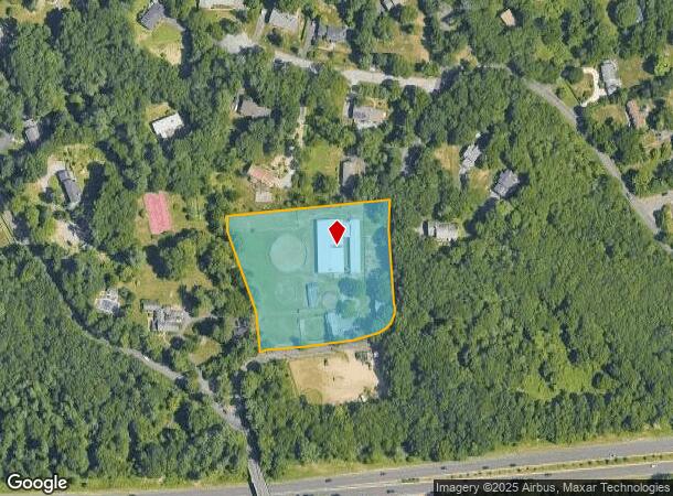
Property Record
43 Bangall Rd, Stamford, CT 06903
Current Lease Availabilities
NEARBY LISTINGS FOR SALE OR LEASE
Property Detail
43 Bangall Rd
Bridgeport-Stamford-Norwalk, CT
Fairfield
STAM-000002-000000-001173
Connecticut
Ruralagriculturalresidence
3.32 AC
X
Stamford
09001C0502F
Westchester/So Connecticut
DEMOGRAPHICS near 43 Bangall Rd
1 Mile
3 Mile
5 Mile
2024 Total Population
2,460
35,275
170,935
2029 Population
2,476
35,394
172,201
Pop Growth 2024-2029
+ 0.65%
+ 0.34%
+ 0.74%
Average Age
45
43
39
2024 Total Households
850
12,340
65,170
HH Growth 2024-2029
+ 0.59%
+ 0.24%
+ 0.96%
Median Household Inc
$199,599
$171,635
$116,706
Avg Household Size
2.80
2.70
2.50
2024 Avg HH Vehicles
2.00
2.00
2.00
Median Home Value
$831,330
$784,575
$771,209
Median Year Built
1965
1962
1971
Nearby Places
Map Layers
Map Styles
 Street
 Aerial
- Restaurants
- Banks
- Shops
- Fitness
- Groceries
PUBLIC TRANSPORTATION
COMMUTER RAIL
Springdale Mw Facility (New Canaan - Metro-North Railroad)
DRIVE
WALK
Distance
Springdale Mw Facility (New Canaan - Metro-North Railroad)
13 min
5.0 mi
Springdale Station (New Haven Line - Metro-North Commuter Railroad Company (Metro-North))
DRIVE
WALK
Distance
Springdale Station (New Haven Line - Metro-North Commuter Railroad Company (Metro-North))
13 min
5.8 mi
AIRPORT
Westchester County
DRIVE
WALK
Distance
Westchester County
22 min
12.9 mi
LaGuardia
DRIVE
WALK
Distance
LaGuardia
56 min
35.7 mi
Freight Ports
NY - Red Hook Container Terminal
DRIVE
WALK
Distance
NY - Red Hook Container Terminal
71 min
46.2 mi
Nearby Properties
Address
Land Use
TOTAL SIZE
Lot Size
Zoning
Address
Land Use
TOTAL SIZE
Lot Size
Zoning
98,106 SF
42.71 AC
RA-2
Address
Land Use
TOTAL SIZE
Lot Size
Zoning
32.43 AC
RA1
Address
Land Use
TOTAL SIZE
Lot Size
Zoning
25.91 AC
MZN
Address
Land Use
TOTAL SIZE
Lot Size
Zoning
29.87 AC
R10
Address
Land Use
TOTAL SIZE
Lot Size
Zoning
26.11 AC
CN
Address
Land Use
TOTAL SIZE
Lot Size
Zoning
75,531 SF
6.85 AC
MZN
Address
Land Use
TOTAL SIZE
Lot Size
Zoning
277,836 SF
2.17 AC
CB
Address
Land Use
TOTAL SIZE
Lot Size
Zoning
34.05 AC
RA1
Address
Land Use
TOTAL SIZE
Lot Size
Zoning
16.99 AC
CD
Address
Land Use
TOTAL SIZE
Lot Size
Zoning
28.54 AC
R20
Address
Land Use
TOTAL SIZE
Lot Size
Zoning
23.84 AC
CD
Address
Land Use
TOTAL SIZE
Lot Size
Zoning
219,634 SF
10 AC
CD
Address
Land Use
TOTAL SIZE
Lot Size
Zoning
204.81 AC
RA-4
Address
Land Use
TOTAL SIZE
Lot Size
Zoning
7.84 AC
BD
Address
Land Use
TOTAL SIZE
Lot Size
Zoning
196,860 SF
CN
Address
Land Use
TOTAL SIZE
Lot Size
Zoning
40.46 AC
RA2
Address
Land Use
TOTAL SIZE
Lot Size
Zoning
3,705 SF
158.41 AC
RA-2
Address
Land Use
TOTAL SIZE
Lot Size
Zoning
160,203 SF
12.38 AC
MZN
Address
Land Use
TOTAL SIZE
Lot Size
Zoning
90,690 SF
12.80 AC
R20
Address
Land Use
TOTAL SIZE
Lot Size
Zoning
36.58 AC
CD
Address
Land Use
TOTAL SIZE
Lot Size
Zoning
14.07 AC
CD
Address
Land Use
TOTAL SIZE
Lot Size
Zoning
3.50 AC
CN
Address
Land Use
TOTAL SIZE
Lot Size
Zoning
12.22 AC
RA1
Address
Land Use
TOTAL SIZE
Lot Size
Zoning
15 AC
CD
Address
Land Use
TOTAL SIZE
Lot Size
Zoning
8,337 SF
132.50 AC
P
Address
Land Use
TOTAL SIZE
Lot Size
Zoning
87,525 SF
16.87 AC
RA1
Address
Land Use
TOTAL SIZE
Lot Size
Zoning
69,558 SF
10 AC
RD
Address
Land Use
TOTAL SIZE
Lot Size
Zoning
90,532 SF
14.79 AC
RA1
Address
Land Use
TOTAL SIZE
Lot Size
Zoning
4,981 SF
10.19 AC
RA-4
Address
Land Use
TOTAL SIZE
Lot Size
Zoning
84.37 AC
RA2
The World's #1 Commercial Real Estate Marketplace
Connect with us
© 2025 CoStar Group
The information above has been obtained from sources believed reliable. While we do not doubt its accuracy we have not verified it and make no guarantee, warranty or representation about it. It is your responsibility to independently confirm its accuracy and completeness. Any projections, opinions, assumptions, or estimates used are for example only and do not represent the current or future performance of the property. The value of this transaction to you depends on tax and other factors which should be evaluated by your tax, financial, and legal advisors. You and your advisors should conduct a careful, independent investigation of the property to determine to your satisfaction the suitability of the property for your needs.