Property Record
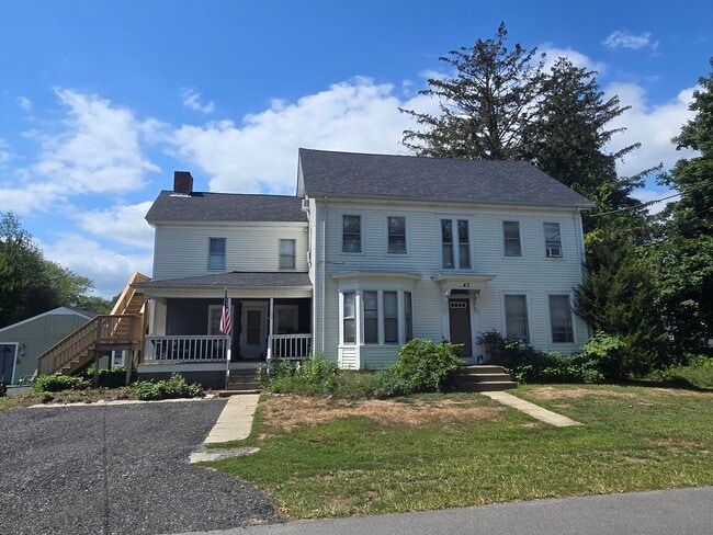
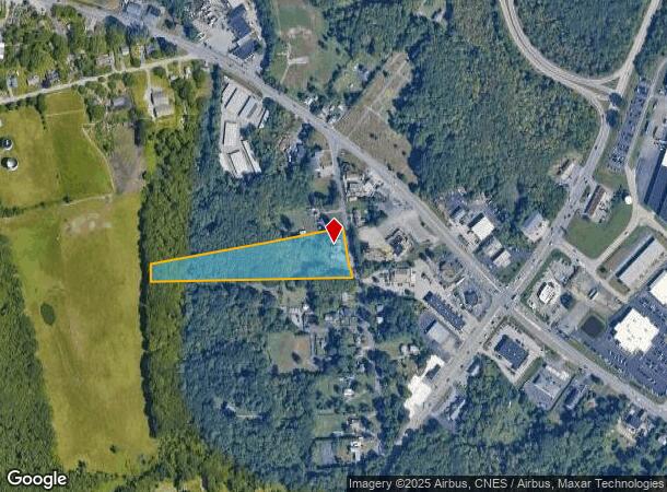
43 Baptist St, Swansea, MA 02777
This Property Is For Sale
NEARBY LISTINGS FOR SALE OR LEASE
Property Detail
43 Baptist St
Multifamilydwelling
Bristol
X
Massachusetts
25005C0219G
6.60 AC
2025
Outlying Bristol County
2025
Boston
645103
Providence-Warwick, RI-MA
3,982 SF
SWAN-000350-000003
DEMOGRAPHICS near 43 Baptist St
1 Mile
3 Mile
5 Mile
2024 Total Population
1,359
21,787
79,515
2029 Population
1,395
21,923
80,771
Pop Growth 2024-2029
+ 2.65%
+ 0.62%
+ 1.58%
Average Age
45
43
44
2024 Total Households
486
8,538
32,069
HH Growth 2024-2029
+ 2.67%
+ 0.47%
+ 1.60%
Median Household Inc
$122,499
$113,119
$107,196
Avg Household Size
2.70
2.50
2.40
2024 Avg HH Vehicles
3.00
2.00
2.00
Median Home Value
$513,750
$506,498
$475,828
Median Year Built
1984
1966
1964
Nearby Places
Map Layers
Map Styles
 Street
 Aerial
- Restaurants
- Banks
- Shops
- Fitness
- Groceries
PUBLIC TRANSPORTATION
AIRPORT
Rhode Island Tf Green International
DRIVE
WALK
Distance
Rhode Island Tf Green International
28 min
17.1 mi
Freight Ports
Port of Davisville, RI
DRIVE
WALK
Distance
Port of Davisville, RI
44 min
29.5 mi
Nearby Properties
Address
Land Use
TOTAL SIZE
Lot Size
Zoning
Address
Land Use
TOTAL SIZE
Lot Size
Zoning
367,305 SF
8.23 AC
WF
Address
Land Use
TOTAL SIZE
Lot Size
Zoning
248,000 SF
75.88 AC
I
Address
Land Use
TOTAL SIZE
Lot Size
Zoning
17,500 SF
5.92 AC
WF
Address
Land Use
TOTAL SIZE
Lot Size
Zoning
179,889 SF
17.96 AC
C
Address
Land Use
TOTAL SIZE
Lot Size
Zoning
2.71 AC
B
Address
Land Use
TOTAL SIZE
Lot Size
Zoning
152,620 SF
20.73 AC
C
Address
Land Use
TOTAL SIZE
Lot Size
Zoning
140,460 SF
12.50 AC
R10
Address
Land Use
TOTAL SIZE
Lot Size
Zoning
4.39 AC
B
Address
Land Use
TOTAL SIZE
Lot Size
Zoning
24,480 SF
4.69 AC
C
Address
Land Use
TOTAL SIZE
Lot Size
Zoning
199,796 SF
9.11 AC
RB
Address
Land Use
TOTAL SIZE
Lot Size
Zoning
51,308 SF
10.34 AC
C
Address
Land Use
TOTAL SIZE
Lot Size
Zoning
31,338 SF
0.95 AC
GI
Address
Land Use
TOTAL SIZE
Lot Size
Zoning
31,588 SF
18.21 AC
RE
Address
Land Use
TOTAL SIZE
Lot Size
Zoning
91,510 SF
Address
Land Use
TOTAL SIZE
Lot Size
Zoning
48,986 SF
10.33 AC
RE
Address
Land Use
TOTAL SIZE
Lot Size
Zoning
19,799 SF
13.36 AC
GI
Address
Land Use
TOTAL SIZE
Lot Size
Zoning
36,188 SF
65 AC
R1
Address
Land Use
TOTAL SIZE
Lot Size
Zoning
64,850 SF
11.67 AC
CI
Address
Land Use
TOTAL SIZE
Lot Size
Zoning
76,763 SF
12.60 AC
Address
Land Use
TOTAL SIZE
Lot Size
Zoning
91,235 SF
Address
Land Use
TOTAL SIZE
Lot Size
Zoning
112,123 SF
Address
Land Use
TOTAL SIZE
Lot Size
Zoning
23,758 SF
6 AC
C
Address
Land Use
TOTAL SIZE
Lot Size
Zoning
61,743 SF
42.75 AC
R20
Address
Land Use
TOTAL SIZE
Lot Size
Zoning
36,316 SF
8.38 AC
C
Address
Land Use
TOTAL SIZE
Lot Size
Zoning
1.89 AC
R25
Address
Land Use
TOTAL SIZE
Lot Size
Zoning
3.99 AC
C1
Address
Land Use
TOTAL SIZE
Lot Size
Zoning
13,314 SF
1.73 AC
C
Address
Land Use
TOTAL SIZE
Lot Size
Zoning
2.47 AC
WB
Address
Land Use
TOTAL SIZE
Lot Size
Zoning
72.90 AC
WR
Address
Land Use
TOTAL SIZE
Lot Size
Zoning
39,809 SF
4.80 AC
C
The World's #1 Commercial Real Estate Marketplace
Connect with us
© 2025 CoStar Group
The information above has been obtained from sources believed reliable. While we do not doubt its accuracy we have not verified it and make no guarantee, warranty or representation about it. It is your responsibility to independently confirm its accuracy and completeness. Any projections, opinions, assumptions, or estimates used are for example only and do not represent the current or future performance of the property. The value of this transaction to you depends on tax and other factors which should be evaluated by your tax, financial, and legal advisors. You and your advisors should conduct a careful, independent investigation of the property to determine to your satisfaction the suitability of the property for your needs.