Property Record
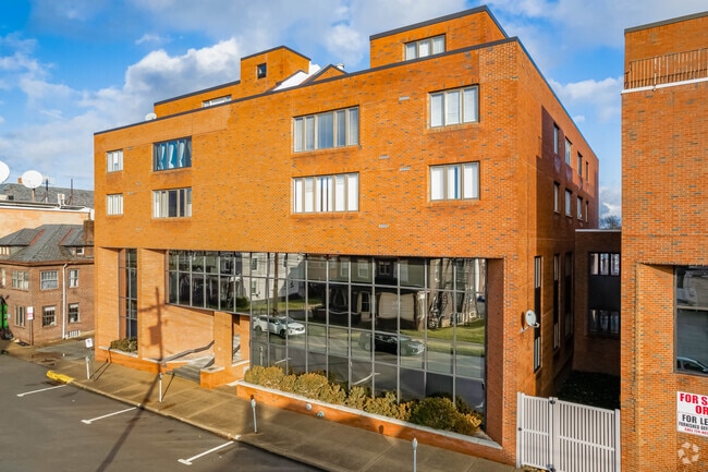
43 S 9Th St, Indiana, PA 15701


NEARBY LISTINGS FOR SALE OR LEASE
Property Detail
43 S 9Th St
24-003-222
S W Jack Towers
Commercialofficeresidentialmixeduse
LOT 100X100 9 CB FULL INT
X
Indiana
42063C0382F
Pennsylvania
2025
0.23 AC
2025
Pennsylvania Central Area
961104
Other Market Areas
17,252 SF
Indiana, PA
DEMOGRAPHICS near 43 S 9Th St
1 Mile
3 Mile
5 Mile
2024 Total Population
16,143
27,594
33,845
2029 Population
16,127
27,645
33,841
Pop Growth 2024-2029
(0.10%)
+ 0.18%
(0.01%)
Average Age
33
38
39
2024 Total Households
5,560
10,947
13,029
HH Growth 2024-2029
(0.16%)
+ 0.18%
(0.02%)
Median Household Inc
$35,927
$46,989
$50,710
Avg Household Size
2.10
2.10
2.10
2024 Avg HH Vehicles
2.00
2.00
2.00
Median Home Value
$136,882
$161,475
$161,484
Median Year Built
1956
1971
1971
Nearby Places
Map Layers
Map Styles
 Street
 Aerial
- Restaurants
- Banks
- Shops
- Fitness
- Groceries
PUBLIC TRANSPORTATION
AIRPORT
Arnold Palmer Regional
DRIVE
WALK
Distance
Arnold Palmer Regional
50 min
33.3 mi
Freight Ports
Port of Baltimore
DRIVE
WALK
Distance
Port of Baltimore
268 min
220.0 mi
SALE & LEASE HISTORY
LISTING DATE
SALE/LEASE

Sep 23, 2016
For Sale
Jan 13, 2023
For Sale
Nearby Properties
Address
Land Use
TOTAL SIZE
Lot Size
Zoning
Address
Land Use
TOTAL SIZE
Lot Size
Zoning
68,928 SF
7.83 AC
Address
Land Use
TOTAL SIZE
Lot Size
Zoning
92,892 SF
60.52 AC
Address
Land Use
TOTAL SIZE
Lot Size
Zoning
250,984 SF
3 AC
Address
Land Use
TOTAL SIZE
Lot Size
Zoning
70,284 SF
28.33 AC
Address
Land Use
TOTAL SIZE
Lot Size
Zoning
881,328 SF
48.47 AC
Address
Land Use
TOTAL SIZE
Lot Size
Zoning
100,000 SF
11.44 AC
Address
Land Use
TOTAL SIZE
Lot Size
Zoning
3,015 SF
27.71 AC
Address
Land Use
TOTAL SIZE
Lot Size
Zoning
38,241 SF
18.07 AC
Address
Land Use
TOTAL SIZE
Lot Size
Zoning
139,400 SF
55 AC
Address
Land Use
TOTAL SIZE
Lot Size
Zoning
41,436 SF
10.80 AC
Address
Land Use
TOTAL SIZE
Lot Size
Zoning
38,440 SF
2.06 AC
Address
Land Use
TOTAL SIZE
Lot Size
Zoning
28,828 SF
1.13 AC
Address
Land Use
TOTAL SIZE
Lot Size
Zoning
81,431 SF
5.68 AC
Address
Land Use
TOTAL SIZE
Lot Size
Zoning
57,760 SF
1.43 AC
Address
Land Use
TOTAL SIZE
Lot Size
Zoning
9,180 SF
22.93 AC
Address
Land Use
TOTAL SIZE
Lot Size
Zoning
43,644 SF
1.24 AC
Address
Land Use
TOTAL SIZE
Lot Size
Zoning
28,812 SF
2.48 AC
Address
Land Use
TOTAL SIZE
Lot Size
Zoning
116,124 SF
5.02 AC
Address
Land Use
TOTAL SIZE
Lot Size
Zoning
153,074 SF
Address
Land Use
TOTAL SIZE
Lot Size
Zoning
56,960 SF
2.17 AC
Address
Land Use
TOTAL SIZE
Lot Size
Zoning
28,743 SF
1.66 AC
Address
Land Use
TOTAL SIZE
Lot Size
Zoning
63,744 SF
1.15 AC
Address
Land Use
TOTAL SIZE
Lot Size
Zoning
78,655 SF
2.77 AC
Address
Land Use
TOTAL SIZE
Lot Size
Zoning
51,320 SF
1.52 AC
Address
Land Use
TOTAL SIZE
Lot Size
Zoning
50,922 SF
1.53 AC
Address
Land Use
TOTAL SIZE
Lot Size
Zoning
56,842 SF
1.58 AC
Address
Land Use
TOTAL SIZE
Lot Size
Zoning
60,080 SF
0.65 AC
Address
Land Use
TOTAL SIZE
Lot Size
Zoning
72,606 SF
17.50 AC
Address
Land Use
TOTAL SIZE
Lot Size
Zoning
46,546 SF
15 AC
The World's #1 Commercial Real Estate Marketplace
Connect with us
© 2026 CoStar Group
The information above has been obtained from sources believed reliable. While we do not doubt its accuracy we have not verified it and make no guarantee, warranty or representation about it. It is your responsibility to independently confirm its accuracy and completeness. Any projections, opinions, assumptions, or estimates used are for example only and do not represent the current or future performance of the property. The value of this transaction to you depends on tax and other factors which should be evaluated by your tax, financial, and legal advisors. You and your advisors should conduct a careful, independent investigation of the property to determine to your satisfaction the suitability of the property for your needs.