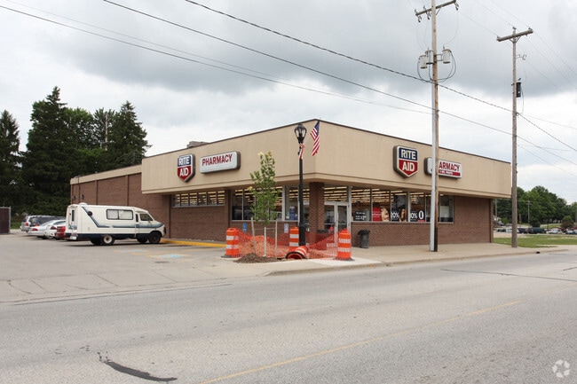
Property Record
43 S Maple St, Grant, MI 49327

NEARBY LISTINGS FOR SALE OR LEASE
-
-
View all Grant listings for lease on LoopNet.com
Property Detail
43 S Maple St
22-24-128-004
Village Of Grant
Drugstorepharmacycvswalgreens
LOT 3 BLK 1 SQUIER & BURRIL'S ADDITION TO THE VILLAGE OF GRANT
X
Newaygo
26081C0025D
Michigan
2025
3
2025
0.31 AC
971200
Newaygo County
7,076 SF
West Michigan
DEMOGRAPHICS near 43 S Maple St
1 Mile
3 Mile
5 Mile
2024 Total Population
1,241
2,931
8,440
2029 Population
1,271
3,005
8,792
Pop Growth 2024-2029
+ 2.42%
+ 2.52%
+ 4.17%
Average Age
37
37
40
2024 Total Households
439
1,041
3,121
HH Growth 2024-2029
+ 2.05%
+ 2.31%
+ 4.20%
Median Household Inc
$63,813
$61,661
$64,751
Avg Household Size
2.80
2.80
2.70
2024 Avg HH Vehicles
2.00
2.00
2.00
Median Home Value
$174,999
$176,454
$187,923
Median Year Built
1976
1977
1980
Nearby Places
Map Layers
Map Styles
 Street
 Aerial
- Restaurants
- Banks
- Shops
- Fitness
- Groceries
PUBLIC TRANSPORTATION
AIRPORT
Gerald R Ford International
DRIVE
WALK
Distance
Gerald R Ford International
61 min
43.0 mi
SALE & LEASE HISTORY
LISTING DATE
SALE/LEASE

Nov 29, 2024
For Sale
Jun 26, 2025
For Lease
Jun 26, 2025
For Sale
Jul 18, 2024
For Sale
Nearby Properties
Address
Land Use
TOTAL SIZE
Lot Size
Zoning
Address
Land Use
TOTAL SIZE
Lot Size
Zoning
LOCAL ZONE
Address
Land Use
TOTAL SIZE
Lot Size
Zoning
40,368 SF
5.02 AC
LOCAL ZONE
Address
Land Use
TOTAL SIZE
Lot Size
Zoning
2,000 SF
35.85 AC
LOCAL ZONE
Address
Land Use
TOTAL SIZE
Lot Size
Zoning
28,341 SF
26.51 AC
LOCAL ZONE
Address
Land Use
TOTAL SIZE
Lot Size
Zoning
3,200 SF
0.49 AC
LOCAL ZONE
Address
Land Use
TOTAL SIZE
Lot Size
Zoning
20,348 SF
3.03 AC
LOCAL ZONE
Address
Land Use
TOTAL SIZE
Lot Size
Zoning
27,120 SF
4.50 AC
LOCAL ZONE
Address
Land Use
TOTAL SIZE
Lot Size
Zoning
4,077 SF
0.30 AC
LOCAL ZONE
Address
Land Use
TOTAL SIZE
Lot Size
Zoning
240 AC
LOCAL ZONE
Address
Land Use
TOTAL SIZE
Lot Size
Zoning
80 AC
LOCAL ZONE
Address
Land Use
TOTAL SIZE
Lot Size
Zoning
14,900 SF
4.91 AC
LOCAL ZONE
Address
Land Use
TOTAL SIZE
Lot Size
Zoning
23,634 SF
4.45 AC
LOCAL ZONE
Address
Land Use
TOTAL SIZE
Lot Size
Zoning
5,040 SF
1.16 AC
LOCAL ZONE
Address
Land Use
TOTAL SIZE
Lot Size
Zoning
144.49 AC
LOCAL ZONE
Address
Land Use
TOTAL SIZE
Lot Size
Zoning
159 AC
LOCAL ZONE
Address
Land Use
TOTAL SIZE
Lot Size
Zoning
63.30 AC
LOCAL ZONE
Address
Land Use
TOTAL SIZE
Lot Size
Zoning
7,200 SF
2.22 AC
LOCAL ZONE
Address
Land Use
TOTAL SIZE
Lot Size
Zoning
59.20 AC
LOCAL ZONE
Address
Land Use
TOTAL SIZE
Lot Size
Zoning
3,600 SF
10 AC
C - 1
Address
Land Use
TOTAL SIZE
Lot Size
Zoning
44,604 SF
5.36 AC
LOCAL ZONE
Address
Land Use
TOTAL SIZE
Lot Size
Zoning
53,386 SF
9.21 AC
LOCAL ZONE
Address
Land Use
TOTAL SIZE
Lot Size
Zoning
120 AC
LOCAL ZONE
Address
Land Use
TOTAL SIZE
Lot Size
Zoning
15,216 SF
1.17 AC
LOCAL ZONE
Address
Land Use
TOTAL SIZE
Lot Size
Zoning
141.70 AC
LOCAL ZONE
Address
Land Use
TOTAL SIZE
Lot Size
Zoning
9,069 SF
1.10 AC
LOCAL ZONE
Address
Land Use
TOTAL SIZE
Lot Size
Zoning
2,440 SF
1 AC
LOCAL ZONE
Address
Land Use
TOTAL SIZE
Lot Size
Zoning
Address
Land Use
TOTAL SIZE
Lot Size
Zoning
80 AC
LOCAL ZONE
Address
Land Use
TOTAL SIZE
Lot Size
Zoning
14,840 SF
1.87 AC
R1
The World's #1 Commercial Real Estate Marketplace
Connect with us
© 2026 CoStar Group
The information above has been obtained from sources believed reliable. While we do not doubt its accuracy we have not verified it and make no guarantee, warranty or representation about it. It is your responsibility to independently confirm its accuracy and completeness. Any projections, opinions, assumptions, or estimates used are for example only and do not represent the current or future performance of the property. The value of this transaction to you depends on tax and other factors which should be evaluated by your tax, financial, and legal advisors. You and your advisors should conduct a careful, independent investigation of the property to determine to your satisfaction the suitability of the property for your needs.