Property Record
43 State St, Groveton, NH 03582


Save to a Folder
{{folder.Name}}
{{folder.ListingIds.length}} Properties
{{folder.ListingIds.length}} Property
Create a New Folder
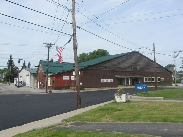
Property Detail
43 State St
Storebuilding
Coos
RESID
New Hampshire
B and X Area of moderate flood hazard, usually the area between the limits of the 100-year and 500-year floods.
1
2024
1.03 AC
2024
Concord/New Hampshire North Area
950400
Other Market Areas
11,816 SF
NRLD-000104-000000-000001
NEARBY LISTINGS FOR SALE OR LEASE
-
-
View all Groveton listings for sale on LoopNet.com
DEMOGRAPHICS near 43 State St
1 mile
3 mile
5 mile
2025 Total Population
1,341
1,835
2,677
2030 Population
1,350
1,844
2,700
Pop Growth 2025-2030
+ 0.67%
+ 0.49%
+ 0.86%
Average Age
44
45
46
2025 Total Households
578
799
1,184
HH Growth 2025-2030
+ 0.52%
+ 0.38%
+ 0.68%
Median Household Inc
$53,430
$53,058
$53,440
Avg Household Size
2.10
2.20
2.20
2025 Avg HH Vehicles
2.00
2.00
2.00
Median Home Value
$122,353
$126,495
$139,024
Median Year Built
1950
1953
1959
Nearby Places
Map Layers
Map Styles
 Street
 Aerial
Layers
 Traffic
 Biking
Places
Listings with unknown addresses are not visible on the map
- Restaurants
- Banks
- Shops
- Fitness
- Groceries
SALE & LEASE HISTORY
LISTING DATE
SALE/LEASE

Sep 23, 2016
For Sale
Nearby Properties
Address
Land Use
TOTAL SIZE
Lot Size
Zoning
Address
Land Use
TOTAL SIZE
Lot Size
Zoning
624 SF
14 AC
COMMER
Address
Land Use
TOTAL SIZE
Lot Size
Zoning
R1 R
Address
Land Use
TOTAL SIZE
Lot Size
Zoning
57,590 SF
1.20 AC
COMMER
Address
Land Use
TOTAL SIZE
Lot Size
Zoning
6,300 SF
8.36 AC
LIGHT
Address
Land Use
TOTAL SIZE
Lot Size
Zoning
30,800 SF
61.16 AC
LIGHT
Address
Land Use
TOTAL SIZE
Lot Size
Zoning
61,068 SF
10.80 AC
COMMER
Address
Land Use
TOTAL SIZE
Lot Size
Zoning
8,848 SF
6.14 AC
HEAVY
Address
Land Use
TOTAL SIZE
Lot Size
Zoning
24,449 SF
1.20 AC
COMMER
Address
Land Use
TOTAL SIZE
Lot Size
Zoning
7,217 SF
0.70 AC
RESID
Address
Land Use
TOTAL SIZE
Lot Size
Zoning
30,128 SF
6.90 AC
COMMER
Address
Land Use
TOTAL SIZE
Lot Size
Zoning
Address
Land Use
TOTAL SIZE
Lot Size
Zoning
7,629 SF
289 AC
RESID
Address
Land Use
TOTAL SIZE
Lot Size
Zoning
3,928 SF
3.30 AC
C/I-CO
Address
Land Use
TOTAL SIZE
Lot Size
Zoning
1,187 SF
0.95 AC
RESID
Address
Land Use
TOTAL SIZE
Lot Size
Zoning
Address
Land Use
TOTAL SIZE
Lot Size
Zoning
3.38 AC
HEAVY
Address
Land Use
TOTAL SIZE
Lot Size
Zoning
2 AC
HEAVY
Address
Land Use
TOTAL SIZE
Lot Size
Zoning
9,352 SF
3.83 AC
LIGHT
Address
Land Use
TOTAL SIZE
Lot Size
Zoning
43,091 SF
2.54 AC
Address
Land Use
TOTAL SIZE
Lot Size
Zoning
6.20 AC
RESID
Address
Land Use
TOTAL SIZE
Lot Size
Zoning
8,541 SF
0.74 AC
COMMER
Address
Land Use
TOTAL SIZE
Lot Size
Zoning
13,050 SF
0.29 AC
COMMER
Address
Land Use
TOTAL SIZE
Lot Size
Zoning
11,520 SF
0.50 AC
COMMER
Address
Land Use
TOTAL SIZE
Lot Size
Zoning
8,500 SF
0.52 AC
COMMER
Address
Land Use
TOTAL SIZE
Lot Size
Zoning
Address
Land Use
TOTAL SIZE
Lot Size
Zoning
5,740 SF
49 AC
LIGHT
Address
Land Use
TOTAL SIZE
Lot Size
Zoning
4,620 SF
0.31 AC
COMMER
Address
Land Use
TOTAL SIZE
Lot Size
Zoning
3,250 SF
0.63 AC
COMMER
Address
Land Use
TOTAL SIZE
Lot Size
Zoning
8,943 SF
0.48 AC
COMMER
Address
Land Use
TOTAL SIZE
Lot Size
Zoning
4,512 SF
1.90 AC
COMMER
The World's #1 Commercial Real Estate Marketplace
Connect with us
© 2026 CoStar Group
The information above has been obtained from sources believed reliable. While we do not doubt its accuracy we have not verified it and make no guarantee, warranty or representation about it. It is your responsibility to independently confirm its accuracy and completeness. Any projections, opinions, assumptions, or estimates used are for example only and do not represent the current or future performance of the property. The value of this transaction to you depends on tax and other factors which should be evaluated by your tax, financial, and legal advisors. You and your advisors should conduct a careful, independent investigation of the property to determine to your satisfaction the suitability of the property for your needs.