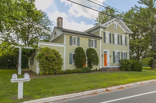
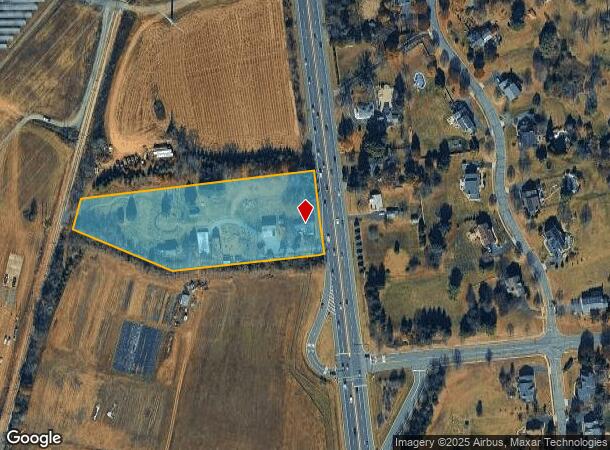
Property Record
43-31 Us Highway 202, Ringoes, NJ 08551

NEARBY LISTINGS FOR SALE OR LEASE
Property Detail
43-31 Us Highway 202
21-00086-0000-00026-01
Hunterdon
Restaurantbuilding
New Jersey
X
26.1
34019C0353F
3.62 AC
2024
Hunterdon
2025
Northern New Jersey
011305
Newark, NJ-PA
4,876 SF
DEMOGRAPHICS near 43-31 Us Highway 202
1 Mile
3 Mile
5 Mile
2024 Total Population
967
7,068
32,009
2029 Population
977
7,125
32,519
Pop Growth 2024-2029
+ 1.03%
+ 0.81%
+ 1.59%
Average Age
43
45
43
2024 Total Households
319
2,626
12,128
HH Growth 2024-2029
+ 0.94%
+ 0.76%
+ 1.57%
Median Household Inc
$174,500
$127,396
$119,325
Avg Household Size
3.00
2.70
2.60
2024 Avg HH Vehicles
2.00
2.00
2.00
Median Home Value
$659,653
$515,055
$464,037
Median Year Built
1992
1983
1982
Nearby Places
Map Layers
Map Styles
 Street
 Aerial
- Restaurants
- Banks
- Shops
- Fitness
- Groceries
PUBLIC TRANSPORTATION
AIRPORT
Trenton Mercer
DRIVE
WALK
Distance
Trenton Mercer
28 min
16.0 mi
Freight Ports
Port of Philadelphia
DRIVE
WALK
Distance
Port of Philadelphia
65 min
38.4 mi
SALE & LEASE HISTORY
LISTING DATE
SALE/LEASE

May 22, 2021
For Sale
Nearby Properties
Address
Land Use
TOTAL SIZE
Lot Size
Zoning
Address
Land Use
TOTAL SIZE
Lot Size
Zoning
65.10 AC
I-1
Address
Land Use
TOTAL SIZE
Lot Size
Zoning
Address
Land Use
TOTAL SIZE
Lot Size
Zoning
40 AC
AR-2
Address
Land Use
TOTAL SIZE
Lot Size
Zoning
Address
Land Use
TOTAL SIZE
Lot Size
Zoning
12.75 AC
B-2
Address
Land Use
TOTAL SIZE
Lot Size
Zoning
5.47 AC
B-2
Address
Land Use
TOTAL SIZE
Lot Size
Zoning
6.16 AC
B-2
Address
Land Use
TOTAL SIZE
Lot Size
Zoning
9.94 AC
B-2
Address
Land Use
TOTAL SIZE
Lot Size
Zoning
2.64 AC
B-2
Address
Land Use
TOTAL SIZE
Lot Size
Zoning
31.35 AC
VAL
Address
Land Use
TOTAL SIZE
Lot Size
Zoning
6.57 AC
B-2
Address
Land Use
TOTAL SIZE
Lot Size
Zoning
10.40 AC
B-2
Address
Land Use
TOTAL SIZE
Lot Size
Zoning
300.85 AC
VAL
Address
Land Use
TOTAL SIZE
Lot Size
Zoning
Address
Land Use
TOTAL SIZE
Lot Size
Zoning
3.18 AC
B-2
Address
Land Use
TOTAL SIZE
Lot Size
Zoning
10.26 AC
B-2
Address
Land Use
TOTAL SIZE
Lot Size
Zoning
1,516 SF
5.09 AC
B-2
Address
Land Use
TOTAL SIZE
Lot Size
Zoning
1,560 SF
136.68 AC
AR-2
Address
Land Use
TOTAL SIZE
Lot Size
Zoning
11 AC
VAL
Address
Land Use
TOTAL SIZE
Lot Size
Zoning
3.55 AC
B-2
Address
Land Use
TOTAL SIZE
Lot Size
Zoning
77.26 AC
AR-5
Address
Land Use
TOTAL SIZE
Lot Size
Zoning
148.35 AC
AR-5
Address
Land Use
TOTAL SIZE
Lot Size
Zoning
4.23 AC
B-2
Address
Land Use
TOTAL SIZE
Lot Size
Zoning
7.98 AC
B-5
Address
Land Use
TOTAL SIZE
Lot Size
Zoning
Address
Land Use
TOTAL SIZE
Lot Size
Zoning
2.29 AC
B-2
Address
Land Use
TOTAL SIZE
Lot Size
Zoning
72.39 AC
AR-2
Address
Land Use
TOTAL SIZE
Lot Size
Zoning
3.25 AC
B-5
Address
Land Use
TOTAL SIZE
Lot Size
Zoning
10,084 SF
2 AC
VAL
Address
Land Use
TOTAL SIZE
Lot Size
Zoning
31.50 AC
AR-2
The World's #1 Commercial Real Estate Marketplace
Connect with us
© 2025 CoStar Group
The information above has been obtained from sources believed reliable. While we do not doubt its accuracy we have not verified it and make no guarantee, warranty or representation about it. It is your responsibility to independently confirm its accuracy and completeness. Any projections, opinions, assumptions, or estimates used are for example only and do not represent the current or future performance of the property. The value of this transaction to you depends on tax and other factors which should be evaluated by your tax, financial, and legal advisors. You and your advisors should conduct a careful, independent investigation of the property to determine to your satisfaction the suitability of the property for your needs.