Property Record
43 West St, Warwick, NY 10990

Property Detail
43 West St
335405-210-000-0007-001.200-0000
LT 2 BRULATOUR SUB 9842
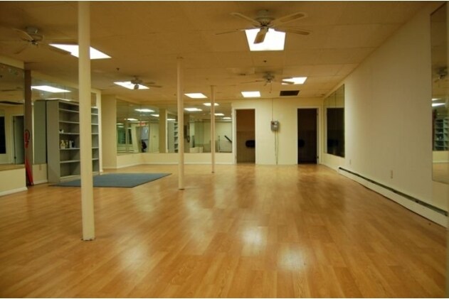
Gymhealthspa
Orange
00710
New York
B and X Area of moderate flood hazard, usually the area between the limits of the 100-year and 500-year floods.
1.200
2024
0.33 AC
2025
Monroe
014602
Northern New Jersey
8,948 SF
Kiryas Joel-Poughkeepsie-Newburgh, NY
NEARBY LISTINGS FOR SALE OR LEASE
DEMOGRAPHICS near 43 West St
1 mile
3 mile
5 mile
2025 Total Population
4,803
12,747
29,766
2030 Population
4,846
12,914
30,281
Pop Growth 2025-2030
+ 0.90%
+ 1.31%
+ 1.73%
Average Age
44
45
44
2025 Total Households
2,056
5,146
11,593
HH Growth 2025-2030
+ 1.02%
+ 1.40%
+ 1.81%
Median Household Inc
$92,790
$108,097
$112,899
Avg Household Size
2.30
2.40
2.50
2025 Avg HH Vehicles
2.00
2.00
2.00
Median Home Value
$440,664
$492,357
$451,587
Median Year Built
1965
1978
1973
Nearby Places
Map Layers
Map Styles
 Street
 Aerial
Layers
 Traffic
 Biking
Places
Listings with unknown addresses are not visible on the map
- Restaurants
- Banks
- Shops
- Fitness
- Groceries
PUBLIC TRANSPORTATION
AIRPORT
New York Stewart International
Drive
Walk
Distance
New York Stewart International
44 min
27.6 mi
Freight Ports
Maher Terminal
Drive
Walk
Distance
Maher Terminal
88 min
60.0 mi
Nearby Properties
Address
Land Use
TOTAL SIZE
Lot Size
Zoning
Address
Land Use
TOTAL SIZE
Lot Size
Zoning
139,701 SF
2.80 AC
00401
Address
Land Use
TOTAL SIZE
Lot Size
Zoning
219,579 SF
34 AC
00220
Address
Land Use
TOTAL SIZE
Lot Size
Zoning
272,000 SF
52.10 AC
00215
Address
Land Use
TOTAL SIZE
Lot Size
Zoning
127,993 SF
11.80 AC
00401
Address
Land Use
TOTAL SIZE
Lot Size
Zoning
63,516 SF
12.30 AC
00401
Address
Land Use
TOTAL SIZE
Lot Size
Zoning
104,100 SF
117.60 AC
00215
Address
Land Use
TOTAL SIZE
Lot Size
Zoning
179,474 SF
31.50 AC
00215
Address
Land Use
TOTAL SIZE
Lot Size
Zoning
96,621 SF
10.20 AC
00450
Address
Land Use
TOTAL SIZE
Lot Size
Zoning
47,951 SF
15.90 AC
00215
Address
Land Use
TOTAL SIZE
Lot Size
Zoning
63,094 SF
22.70 AC
00450
Address
Land Use
TOTAL SIZE
Lot Size
Zoning
64,183 SF
38.90 AC
00750
Address
Land Use
TOTAL SIZE
Lot Size
Zoning
67,401 SF
389.20 AC
00230
Address
Land Use
TOTAL SIZE
Lot Size
Zoning
63,198 SF
5.80 AC
00205
Address
Land Use
TOTAL SIZE
Lot Size
Zoning
22,099 SF
706.60 AC
00240
Address
Land Use
TOTAL SIZE
Lot Size
Zoning
11.20 AC
00230
Address
Land Use
TOTAL SIZE
Lot Size
Zoning
477 SF
0.97 AC
00710
Address
Land Use
TOTAL SIZE
Lot Size
Zoning
0.32 AC
00215
Address
Land Use
TOTAL SIZE
Lot Size
Zoning
87,168 SF
5.30 AC
00210
Address
Land Use
TOTAL SIZE
Lot Size
Zoning
84,367 SF
7.60 AC
00210
Address
Land Use
TOTAL SIZE
Lot Size
Zoning
84,858 SF
4.10 AC
00210
Address
Land Use
TOTAL SIZE
Lot Size
Zoning
16,420 SF
7.50 AC
00210
Address
Land Use
TOTAL SIZE
Lot Size
Zoning
0.24 AC
00710
Address
Land Use
TOTAL SIZE
Lot Size
Zoning
3,120 SF
0.03 AC
DN
Address
Land Use
TOTAL SIZE
Lot Size
Zoning
35,938 SF
6.40 AC
00220
Address
Land Use
TOTAL SIZE
Lot Size
Zoning
141,922 SF
29.20 AC
00710
Address
Land Use
TOTAL SIZE
Lot Size
Zoning
29,378 SF
4 AC
00220
Address
Land Use
TOTAL SIZE
Lot Size
Zoning
0.26 AC
00215
Address
Land Use
TOTAL SIZE
Lot Size
Zoning
54,763 SF
2 AC
00210
Address
Land Use
TOTAL SIZE
Lot Size
Zoning
26,599 SF
2.40 AC
00205
Address
Land Use
TOTAL SIZE
Lot Size
Zoning
20,948 SF
20.40 AC
00450
The World's #1 Commercial Real Estate Marketplace
Connect with us
© 2026 CoStar Group
The information above has been obtained from sources believed reliable. While we do not doubt its accuracy we have not verified it and make no guarantee, warranty or representation about it. It is your responsibility to independently confirm its accuracy and completeness. Any projections, opinions, assumptions, or estimates used are for example only and do not represent the current or future performance of the property. The value of this transaction to you depends on tax and other factors which should be evaluated by your tax, financial, and legal advisors. You and your advisors should conduct a careful, independent investigation of the property to determine to your satisfaction the suitability of the property for your needs.