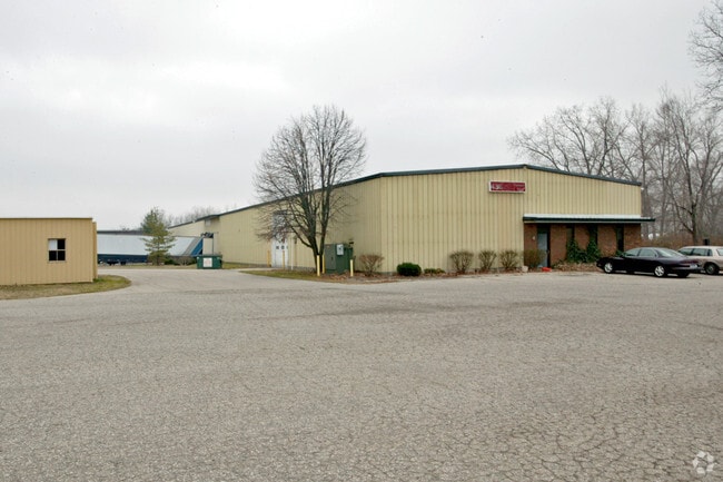
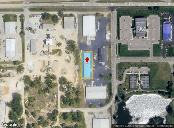
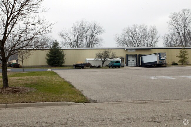
Property Record
430 100Th Ave, Zeeland, MI 49464
NEARBY LISTINGS FOR SALE OR LEASE
Property Detail
430 100Th Ave
Grand Rapids-Wyoming, MI
UNIT 1 PARK SIDE INDUSTRIAL CONDOMINIUM AS RECORDED IN OTTAWA COUNTY REGISTER OF DEEDS DOC #2021-0060811 CONDO PLAN #708 SEC
70-16-24-332-001
Ottawa
Publicstorage
Michigan
2024
0.75 AC
2025
Zeeland
025500
West Michigan
14,820 SF
DEMOGRAPHICS near 430 100Th Ave
1 Mile
3 Mile
5 Mile
2024 Total Population
6,732
33,955
72,041
2029 Population
6,998
35,365
75,124
Pop Growth 2024-2029
+ 3.95%
+ 4.15%
+ 4.28%
Average Age
42
39
38
2024 Total Households
2,707
12,532
26,178
HH Growth 2024-2029
+ 4.06%
+ 4.29%
+ 4.47%
Median Household Inc
$69,207
$80,355
$72,878
Avg Household Size
2.50
2.60
2.60
2024 Avg HH Vehicles
2.00
2.00
2.00
Median Home Value
$245,911
$247,630
$234,232
Median Year Built
1988
1991
1985
Nearby Places
Map Layers
Map Styles
 Street
 Aerial
- Restaurants
- Banks
- Shops
- Fitness
- Groceries
PUBLIC TRANSPORTATION
COMMUTER RAIL
DRIVE
WALK
Distance
8 min
4.2 mi
AIRPORT
Gerald R Ford International
DRIVE
WALK
Distance
Gerald R Ford International
40 min
30.0 mi
Nearby Properties
Address
Land Use
TOTAL SIZE
Lot Size
Zoning
Address
Land Use
TOTAL SIZE
Lot Size
Zoning
1,134,118 SF
73.70 AC
I-2
Address
Land Use
TOTAL SIZE
Lot Size
Zoning
255,407 SF
23.18 AC
I-2
Address
Land Use
TOTAL SIZE
Lot Size
Zoning
349,583 SF
I
Address
Land Use
TOTAL SIZE
Lot Size
Zoning
662,015 SF
177 AC
SEE MAP
Address
Land Use
TOTAL SIZE
Lot Size
Zoning
716,625 SF
123.22 AC
I-2
Address
Land Use
TOTAL SIZE
Lot Size
Zoning
249,051 SF
24.77 AC
LDR
Address
Land Use
TOTAL SIZE
Lot Size
Zoning
594,031 SF
R-1
Address
Land Use
TOTAL SIZE
Lot Size
Zoning
218,722 SF
8.59 AC
AGR
Address
Land Use
TOTAL SIZE
Lot Size
Zoning
82,556 SF
Address
Land Use
TOTAL SIZE
Lot Size
Zoning
259,200 SF
R-1
Address
Land Use
TOTAL SIZE
Lot Size
Zoning
6,000 SF
46.50 AC
I-2
Address
Land Use
TOTAL SIZE
Lot Size
Zoning
226,347 SF
19.44 AC
I-2
Address
Land Use
TOTAL SIZE
Lot Size
Zoning
173,176 SF
28.57 AC
I-1
Address
Land Use
TOTAL SIZE
Lot Size
Zoning
132,127 SF
42.69 AC
SEE MAP
Address
Land Use
TOTAL SIZE
Lot Size
Zoning
35,715 SF
Address
Land Use
TOTAL SIZE
Lot Size
Zoning
230,020 SF
Address
Land Use
TOTAL SIZE
Lot Size
Zoning
58,710 SF
6.96 AC
C-2
Address
Land Use
TOTAL SIZE
Lot Size
Zoning
134,490 SF
15.76 AC
C-2
Address
Land Use
TOTAL SIZE
Lot Size
Zoning
109,988 SF
12.71 AC
OS-1
Address
Land Use
TOTAL SIZE
Lot Size
Zoning
136,520 SF
13.55 AC
PUD
Address
Land Use
TOTAL SIZE
Lot Size
Zoning
1,801 SF
23.26 AC
PUD
Address
Land Use
TOTAL SIZE
Lot Size
Zoning
228,876 SF
49.31 AC
GMU
Address
Land Use
TOTAL SIZE
Lot Size
Zoning
184,944 SF
12.57 AC
R-3
Address
Land Use
TOTAL SIZE
Lot Size
Zoning
3,880 SF
80 AC
RMH
Address
Land Use
TOTAL SIZE
Lot Size
Zoning
77,624 SF
27.32 AC
I-1
Address
Land Use
TOTAL SIZE
Lot Size
Zoning
50,000 SF
20.36 AC
I-2
Address
Land Use
TOTAL SIZE
Lot Size
Zoning
217,226 SF
20.82 AC
I-2
Address
Land Use
TOTAL SIZE
Lot Size
Zoning
181,847 SF
12.99 AC
I-1
Address
Land Use
TOTAL SIZE
Lot Size
Zoning
90,865 SF
4.14 AC
C-2
Address
Land Use
TOTAL SIZE
Lot Size
Zoning
376,204 SF
20.10 AC
I-1
The World's #1 Commercial Real Estate Marketplace
Connect with us
© 2025 CoStar Group
The information above has been obtained from sources believed reliable. While we do not doubt its accuracy we have not verified it and make no guarantee, warranty or representation about it. It is your responsibility to independently confirm its accuracy and completeness. Any projections, opinions, assumptions, or estimates used are for example only and do not represent the current or future performance of the property. The value of this transaction to you depends on tax and other factors which should be evaluated by your tax, financial, and legal advisors. You and your advisors should conduct a careful, independent investigation of the property to determine to your satisfaction the suitability of the property for your needs.