Property Record
430 Carson Ave, Atlantic City, NJ 08401

Save to a Folder
{{folder.Name}}
{{folder.ListingIds.length}} Properties
{{folder.ListingIds.length}} Property
Create a New Folder
Property Detail
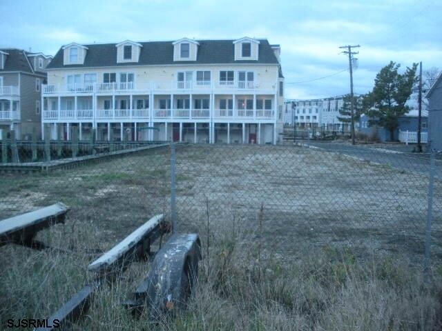
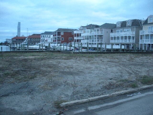
430 Carson Ave
Atlantic City-Hammonton, NJ
FACILITY NAME: BLDG,DOCKS & B. HEAD
02-00566-0000-00033
ATLANTIC
Commercialnec
New Jersey
R-3
33
2025
0.29 AC
2026
Atlantic City/Hammonton
002300
Philadelphia
1,880 SF
NEARBY LISTINGS FOR SALE OR LEASE
DEMOGRAPHICS near 430 Carson Ave
1 mile
3 mile
5 mile
2025 Total Population
16,080
48,143
73,643
2030 Population
16,483
50,264
77,855
Pop Growth 2025-2030
+ 2.51%
+ 4.41%
+ 5.72%
Average Age
41
41
44
2025 Total Households
7,372
20,490
32,199
HH Growth 2025-2030
+ 2.06%
+ 4.75%
+ 6.04%
Median Household Inc
$31,269
$43,937
$57,246
Avg Household Size
2.10
2.20
2.20
2025 Avg HH Vehicles
1.00
1.00
1.00
Median Home Value
$263,922
$324,045
$390,823
Median Year Built
1973
1966
1966
Nearby Places
Map Layers
Map Styles
 Street
 Aerial
Layers
 Traffic
 Biking
Places
Listings with unknown addresses are not visible on the map
- Restaurants
- Banks
- Shops
- Fitness
- Groceries
PUBLIC TRANSPORTATION
COMMUTER RAIL
Atlantic City (Atlantic City Line - NJ Transit Commuter Rail (NJ Transit))
Drive
Walk
Distance
Atlantic City (Atlantic City Line - NJ Transit Commuter Rail (NJ Transit))
8 min
2.5 mi
Absecon (Atlantic City Line - NJ Transit Commuter Rail (NJ Transit))
Drive
Walk
Distance
Absecon (Atlantic City Line - NJ Transit Commuter Rail (NJ Transit))
14 min
7.1 mi
AIRPORT
Atlantic City International
Drive
Walk
Distance
Atlantic City International
44 min
15.5 mi
Freight Ports
Broadway Terminal - Pier 5
Drive
Walk
Distance
Broadway Terminal - Pier 5
75 min
57.9 mi
SALE & LEASE HISTORY
LISTING DATE
SALE/LEASE

Sep 24, 2016
For Sale
Nearby Properties
Address
Land Use
TOTAL SIZE
Lot Size
Zoning
Address
Land Use
TOTAL SIZE
Lot Size
Zoning
25.97 AC
HNRA
Address
Land Use
TOTAL SIZE
Lot Size
Zoning
1.51 AC
RS-C
Address
Land Use
TOTAL SIZE
Lot Size
Zoning
2,497,916 SF
6.96 AC
CBD
Address
Land Use
TOTAL SIZE
Lot Size
Zoning
6.20 AC
RS-C
Address
Land Use
TOTAL SIZE
Lot Size
Zoning
11.04 AC
HNRA
Address
Land Use
TOTAL SIZE
Lot Size
Zoning
5,364 SF
142.55 AC
BFRA
Address
Land Use
TOTAL SIZE
Lot Size
Zoning
14.73 AC
RVRA
Address
Land Use
TOTAL SIZE
Lot Size
Zoning
14.71 AC
RS-C
Address
Land Use
TOTAL SIZE
Lot Size
Zoning
69.16 AC
HNRA
Address
Land Use
TOTAL SIZE
Lot Size
Zoning
398,702 SF
4.05 AC
RS-C
Address
Land Use
TOTAL SIZE
Lot Size
Zoning
9.90 AC
RS-C
Address
Land Use
TOTAL SIZE
Lot Size
Zoning
6,552 SF
3.61 AC
RS
Address
Land Use
TOTAL SIZE
Lot Size
Zoning
3.54 AC
HNRA
Address
Land Use
TOTAL SIZE
Lot Size
Zoning
387,249 SF
49.56 AC
HW-C
Address
Land Use
TOTAL SIZE
Lot Size
Zoning
0.22 AC
RS-C
Address
Land Use
TOTAL SIZE
Lot Size
Zoning
4.33 AC
RS-C
Address
Land Use
TOTAL SIZE
Lot Size
Zoning
Address
Land Use
TOTAL SIZE
Lot Size
Zoning
1.98 AC
RS-C
Address
Land Use
TOTAL SIZE
Lot Size
Zoning
0.78 AC
RS-C
Address
Land Use
TOTAL SIZE
Lot Size
Zoning
2.44 AC
RS-C
Address
Land Use
TOTAL SIZE
Lot Size
Zoning
7.63 AC
RS-C
Address
Land Use
TOTAL SIZE
Lot Size
Zoning
3.01 AC
RS-C
Address
Land Use
TOTAL SIZE
Lot Size
Zoning
2.81 AC
RS-C
Address
Land Use
TOTAL SIZE
Lot Size
Zoning
132 AC
C1
Address
Land Use
TOTAL SIZE
Lot Size
Zoning
192,602 SF
5.80 AC
RS-C
Address
Land Use
TOTAL SIZE
Lot Size
Zoning
277,716 SF
5.45 AC
RS-C
Address
Land Use
TOTAL SIZE
Lot Size
Zoning
1.09 AC
RS-C
Address
Land Use
TOTAL SIZE
Lot Size
Zoning
26,624 SF
47.40 AC
M-C
Address
Land Use
TOTAL SIZE
Lot Size
Zoning
2.13 AC
RS-C
Address
Land Use
TOTAL SIZE
Lot Size
Zoning
1.66 AC
RS-C
The World's #1 Commercial Real Estate Marketplace
Connect with us
© 2026 CoStar Group
The information above has been obtained from sources believed reliable. While we do not doubt its accuracy we have not verified it and make no guarantee, warranty or representation about it. It is your responsibility to independently confirm its accuracy and completeness. Any projections, opinions, assumptions, or estimates used are for example only and do not represent the current or future performance of the property. The value of this transaction to you depends on tax and other factors which should be evaluated by your tax, financial, and legal advisors. You and your advisors should conduct a careful, independent investigation of the property to determine to your satisfaction the suitability of the property for your needs.