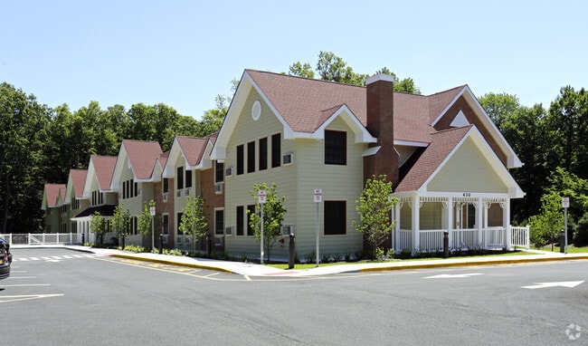
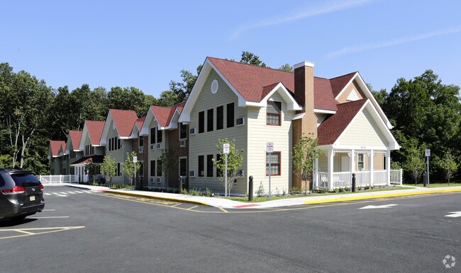
Property Record
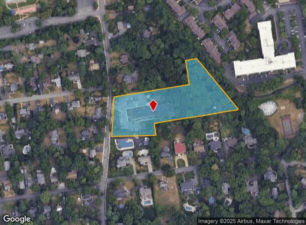
430 Cedar Ln, River Vale, NJ 07675
NEARBY LISTINGS FOR SALE OR LEASE
Property Detail
430 Cedar Ln
New York-Jersey City-White Plains, NY-NJ
3.67 ACRES RESIDENCE
53-01301-0000-00039-01
Bergen
Governmentalpublicusegeneral
New Jersey
X
39.1
34003C0094H
3.67 AC
0
Greater Bergen County
2025
Northern New Jersey
049002
DEMOGRAPHICS near 430 Cedar Ln
1 Mile
3 Mile
5 Mile
2024 Total Population
10,543
77,387
222,795
2029 Population
10,542
77,308
222,631
Pop Growth 2024-2029
(0.01%)
(0.10%)
(0.07%)
Average Age
43
43
43
2024 Total Households
3,740
27,523
76,066
HH Growth 2024-2029
(0.13%)
(0.13%)
(0.12%)
Median Household Inc
$164,881
$147,739
$142,216
Avg Household Size
2.70
2.70
2.80
2024 Avg HH Vehicles
2.00
2.00
2.00
Median Home Value
$681,379
$689,250
$674,346
Median Year Built
1960
1962
1959
Nearby Places
Map Layers
Map Styles
 Street
 Aerial
- Restaurants
- Banks
- Shops
- Fitness
- Groceries
PUBLIC TRANSPORTATION
COMMUTER RAIL
Westwood (Pascack Valley Line - NJ Transit Commuter Rail (NJ Transit))
DRIVE
WALK
Distance
Westwood (Pascack Valley Line - NJ Transit Commuter Rail (NJ Transit))
3 min
1.4 mi
Hillsdale (Pascack Valley Line - NJ Transit Commuter Rail (NJ Transit))
DRIVE
WALK
Distance
Hillsdale (Pascack Valley Line - NJ Transit Commuter Rail (NJ Transit))
4 min
1.7 mi
AIRPORT
LaGuardia
DRIVE
WALK
Distance
LaGuardia
40 min
24.5 mi
Newark Liberty International
DRIVE
WALK
Distance
Newark Liberty International
36 min
27.2 mi
Westchester County
DRIVE
WALK
Distance
Westchester County
44 min
29.7 mi
Freight Ports
NY - Red Hook Container Terminal
DRIVE
WALK
Distance
NY - Red Hook Container Terminal
50 min
28.4 mi
Nearby Properties
Address
Land Use
TOTAL SIZE
Lot Size
Zoning
Address
Land Use
TOTAL SIZE
Lot Size
Zoning
19.96 AC
HSO
Address
Land Use
TOTAL SIZE
Lot Size
Zoning
8.78 AC
HSO
Address
Land Use
TOTAL SIZE
Lot Size
Zoning
59 AC
AA
Address
Land Use
TOTAL SIZE
Lot Size
Zoning
23,572 SF
98.75 AC
CR
Address
Land Use
TOTAL SIZE
Lot Size
Zoning
Address
Land Use
TOTAL SIZE
Lot Size
Zoning
9.20 AC
OR
Address
Land Use
TOTAL SIZE
Lot Size
Zoning
21.74 AC
SC
Address
Land Use
TOTAL SIZE
Lot Size
Zoning
1,620 SF
37.22 AC
R225
Address
Land Use
TOTAL SIZE
Lot Size
Zoning
845.02 AC
Address
Land Use
TOTAL SIZE
Lot Size
Zoning
3.33 AC
R3
Address
Land Use
TOTAL SIZE
Lot Size
Zoning
5.37 AC
B2
Address
Land Use
TOTAL SIZE
Lot Size
Zoning
15,065 SF
9.30 AC
RC
Address
Land Use
TOTAL SIZE
Lot Size
Zoning
191,950 SF
43.03 AC
RA25
Address
Land Use
TOTAL SIZE
Lot Size
Zoning
62,728 SF
14.49 AC
RA15
Address
Land Use
TOTAL SIZE
Lot Size
Zoning
1,295,615 SF
93.54 AC
OP
Address
Land Use
TOTAL SIZE
Lot Size
Zoning
4 AC
HSO
Address
Land Use
TOTAL SIZE
Lot Size
Zoning
144,751 SF
22.87 AC
RA
Address
Land Use
TOTAL SIZE
Lot Size
Zoning
440 SF
98.43 AC
EO
Address
Land Use
TOTAL SIZE
Lot Size
Zoning
8.02 AC
BUS2
Address
Land Use
TOTAL SIZE
Lot Size
Zoning
9.70 AC
Address
Land Use
TOTAL SIZE
Lot Size
Zoning
11.45 AC
A
Address
Land Use
TOTAL SIZE
Lot Size
Zoning
41,552 SF
115.62 AC
A-1
Address
Land Use
TOTAL SIZE
Lot Size
Zoning
8.42 AC
LI
Address
Land Use
TOTAL SIZE
Lot Size
Zoning
6.50 AC
LM
Address
Land Use
TOTAL SIZE
Lot Size
Zoning
161,812 SF
5.66 AC
R3
Address
Land Use
TOTAL SIZE
Lot Size
Zoning
2.95 AC
R3
Address
Land Use
TOTAL SIZE
Lot Size
Zoning
3.50 AC
R3
Address
Land Use
TOTAL SIZE
Lot Size
Zoning
4.50 AC
R3
Address
Land Use
TOTAL SIZE
Lot Size
Zoning
4.90 AC
LM
Address
Land Use
TOTAL SIZE
Lot Size
Zoning
10.16 AC
B2
The World's #1 Commercial Real Estate Marketplace
Connect with us
© 2025 CoStar Group
The information above has been obtained from sources believed reliable. While we do not doubt its accuracy we have not verified it and make no guarantee, warranty or representation about it. It is your responsibility to independently confirm its accuracy and completeness. Any projections, opinions, assumptions, or estimates used are for example only and do not represent the current or future performance of the property. The value of this transaction to you depends on tax and other factors which should be evaluated by your tax, financial, and legal advisors. You and your advisors should conduct a careful, independent investigation of the property to determine to your satisfaction the suitability of the property for your needs.