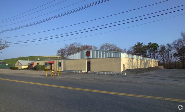
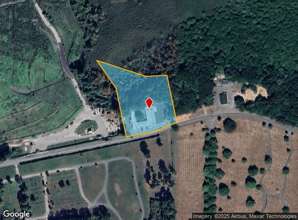
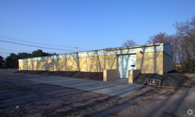
Property Record
430 E Britannia St, Taunton, MA 02780
NEARBY LISTINGS FOR SALE OR LEASE
-
-
View all Taunton listings for sale on LoopNet.com
Property Detail
430 E Britannia St
TAUN-000039-000435
Bristol
Recreationcenter
Massachusetts
A
435
25005C0162G
2.40 AC
2025
Attleboro/New Bedford
2025
Boston
613100
Providence-Warwick, RI-MA
10,620 SF
DEMOGRAPHICS near 430 E Britannia St
1 Mile
3 Mile
5 Mile
2024 Total Population
6,440
48,683
79,026
2029 Population
6,295
48,179
78,533
Pop Growth 2024-2029
(2.25%)
(1.04%)
(0.62%)
Average Age
41
41
41
2024 Total Households
2,637
19,776
31,003
HH Growth 2024-2029
(2.28%)
(1.08%)
(0.70%)
Median Household Inc
$54,146
$61,228
$75,876
Avg Household Size
2.30
2.40
2.50
2024 Avg HH Vehicles
2.00
2.00
2.00
Median Home Value
$352,392
$364,699
$383,736
Median Year Built
1948
1962
1973
Nearby Places
Map Layers
Map Styles
 Street
 Aerial
- Restaurants
- Banks
- Shops
- Fitness
- Groceries
PUBLIC TRANSPORTATION
AIRPORT
Rhode Island Tf Green International
DRIVE
WALK
Distance
Rhode Island Tf Green International
48 min
27.2 mi
Freight Ports
Port of New Bedford Harbor
DRIVE
WALK
Distance
Port of New Bedford Harbor
37 min
24.2 mi
Nearby Properties
Address
Land Use
TOTAL SIZE
Lot Size
Zoning
Address
Land Use
TOTAL SIZE
Lot Size
Zoning
68,024 SF
66.24 AC
RURRES
Address
Land Use
TOTAL SIZE
Lot Size
Zoning
279,756 SF
11.62 AC
OFFDIS
Address
Land Use
TOTAL SIZE
Lot Size
Zoning
130,851 SF
24.43 AC
URBRES
Address
Land Use
TOTAL SIZE
Lot Size
Zoning
133,652 SF
2 AC
Address
Land Use
TOTAL SIZE
Lot Size
Zoning
147,285 SF
0.79 AC
CENBIZ
Address
Land Use
TOTAL SIZE
Lot Size
Zoning
157.20 AC
OPSPAC
Address
Land Use
TOTAL SIZE
Lot Size
Zoning
486,363 SF
41.18 AC
INDUST
Address
Land Use
TOTAL SIZE
Lot Size
Zoning
604,133 SF
42.73 AC
Address
Land Use
TOTAL SIZE
Lot Size
Zoning
335,092 SF
27.12 AC
INDUST
Address
Land Use
TOTAL SIZE
Lot Size
Zoning
681,295 SF
65.93 AC
Address
Land Use
TOTAL SIZE
Lot Size
Zoning
149,234 SF
40.69 AC
Address
Land Use
TOTAL SIZE
Lot Size
Zoning
37.62 AC
URBRES
Address
Land Use
TOTAL SIZE
Lot Size
Zoning
160,798 SF
14.31 AC
INDUST
Address
Land Use
TOTAL SIZE
Lot Size
Zoning
39,910 SF
1.05 AC
CENBIZ
Address
Land Use
TOTAL SIZE
Lot Size
Zoning
196,420 SF
21.78 AC
INDUST
Address
Land Use
TOTAL SIZE
Lot Size
Zoning
14.43 AC
Address
Land Use
TOTAL SIZE
Lot Size
Zoning
5.20 AC
URBRES
Address
Land Use
TOTAL SIZE
Lot Size
Zoning
200,000 SF
14.56 AC
INDUST
Address
Land Use
TOTAL SIZE
Lot Size
Zoning
217,814 SF
11.30 AC
INDUST
Address
Land Use
TOTAL SIZE
Lot Size
Zoning
6.53 AC
URBRES
Address
Land Use
TOTAL SIZE
Lot Size
Zoning
45,786 SF
16 AC
URBRES
Address
Land Use
TOTAL SIZE
Lot Size
Zoning
206,139 SF
21.55 AC
Address
Land Use
TOTAL SIZE
Lot Size
Zoning
198,720 SF
15.10 AC
INDUST
Address
Land Use
TOTAL SIZE
Lot Size
Zoning
36,336 SF
6.35 AC
RURRES
Address
Land Use
TOTAL SIZE
Lot Size
Zoning
114,057 SF
6.43 AC
INDUST
Address
Land Use
TOTAL SIZE
Lot Size
Zoning
8,000 SF
22.31 AC
Address
Land Use
TOTAL SIZE
Lot Size
Zoning
163,752 SF
28.17 AC
INDUST
Address
Land Use
TOTAL SIZE
Lot Size
Zoning
1,783 SF
9.29 AC
Address
Land Use
TOTAL SIZE
Lot Size
Zoning
61,128 SF
0.98 AC
Address
Land Use
TOTAL SIZE
Lot Size
Zoning
107,794 SF
12.51 AC
The World's #1 Commercial Real Estate Marketplace
Connect with us
© 2025 CoStar Group
The information above has been obtained from sources believed reliable. While we do not doubt its accuracy we have not verified it and make no guarantee, warranty or representation about it. It is your responsibility to independently confirm its accuracy and completeness. Any projections, opinions, assumptions, or estimates used are for example only and do not represent the current or future performance of the property. The value of this transaction to you depends on tax and other factors which should be evaluated by your tax, financial, and legal advisors. You and your advisors should conduct a careful, independent investigation of the property to determine to your satisfaction the suitability of the property for your needs.